
Greenwich
| Greenwich | |
|---|---|
 Royal Observatory, Greenwich | |
 One-time Coat of arms of Greenwich | |
 Greenwich | |
| Location within Greater London | |
| Population | 30,578 (Peninsula and Greenwich West wards 2011) |
| OS grid reference | TQ395775 |
| • Charing Cross | 5.5 mi (8.9 km) WNW |
| London borough | |
| Ceremonial county | Greater London |
| Region | |
| Country | England |
| Sovereign state | United Kingdom |
| Post town | LONDON |
| Postcode district | SE10 |
| Dialling code | 020 |
| Police | Metropolitan |
| Fire | London |
| Ambulance | London |
| UK Parliament | |
| London Assembly | |
Greenwich [1] is a district of London. It is the main part of the Borough of Greenwich,[2][3][4] about 8.9 km east south-east of Charing Cross.
The Royal Greenwich Observatory is in Greenwich. It was originally built for the Astronomer Royal. The Oservatory created the Greenwich Meridian (0° longitude) and Greenwich Mean Time (GMT).
Greenwich is a town with a long history. It became the site of a royal palace, the Palace of Placentia, from the 15th century. This was the birthplace of many members of the Tudor dynasty, including Henry VIII and Elizabeth I. The palace became ruined during the English Civil War. It was rebuilt as a hospital by Sir Christopher Wren. These buildings became the a military college in 1873, which lasted until 1998. The town became a popular resort in the 17th century. Many rich houses were built there, such as Vanbrugh Castle (1717). Estates were built above the town centre.
Greenwich was part of Kent until 1889 when the County of London was created.
World heritage site[change | change source]
| UNESCO World Heritage Site | |
|---|---|
 | |
| Location | United Kingdom |
| Criteria | Cultural: i, ii, iv, vi |
| Reference | 795 |
| Inscription | 1997 (21st Session) |
| Extensions | 2008 |
| Area | 109.5 hectares (271 acres) |
| Buffer zone | 174.85 hectares (432.1 acres) |
| Website | whc |
| Coordinates | 51°29′1″N 0°0′21″W / 51.48361°N 0.00583°W |
Maritime Greenwich is a UNESCO World Heritage Site. It is on the River Thames. The site includes buildings along the riverfront, and surrounding the 17th century Queen's House. The group include the complex of the Royal Hospital for Seamen, the Royal Observatory and the Royal Park.[5]
The Royal Hospital was laid out to a master plan created by Christopher Wren.[6] The hospital complex was built over many decades. Other architects who added to this long-term project included Nicholas Hawksmoor.[5]
The core of this group of buildings is the Queen's House which was designed by Inigo Jones. This was the first Palladian building in Britain.[5]
The Royal Observatory is now the baseline for the world's time zone system and for the measurement of longitude around the globe.[5]
The Royal Park is a symmetrical design in an irregular landscape around the buildings of the World Heritage Site. The park was created by André Le Nôtre.[5]
The park and grounds behind the buildings on the river held the competitions for the horse-related events of the 2012 Summer Olympics.[7]
Public transport[change | change source]
National Rail and Docklands Light Railway services call at Greenwich station.
Gallery[change | change source]
-
 Old Royal Naval College and the Queen's House as viewed from the river
 -
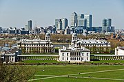 Queen's House and Old Royal Naval College as viewed from the Royal Observatory
 -
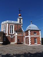 Royal Observatory


References[change | change source]
- ↑ /ˈɡrɛnitʃ/
- ↑ Wells, John C. (2000). Longman Pronunciation Dictionary (2nd ed.). Harlow: Pearson Education Limited. ISBN 0-582-36467-1.
- ↑ Jones, Daniel (1997). English Pronouncing Dictionary (15th ed.). Cambridge: Cambridge University Press. ISBN 0-521-45903-6.
- ↑ Collins English Dictionary (3rd updated ed.). HarperCollins. 1994. ISBN 0-00-470678-1.
- ↑ 5.0 5.1 5.2 5.3 5.4 UNESCO, "Maritime Greenwich"; retrieved 2012-4-19.
- ↑ These buildings became home to the Royal Naval College from 1873 to 1998.
- ↑ London 2012 Olympic and Paralympic Games, "Greenwich Park" Archived 2012-09-09 at Archive.today; retrieved 2012-4-25.
Other websites[change | change source]
- Your Online Guide to Greenwich Archived 2016-01-09 at the Wayback Machine
- Greenwich World Heritage Site — official website Archived 2009-03-01 at the Wayback Machine
- Greenwich Tourist Information Centre Archived 2006-11-29 at the Wayback Machine
- Greenwich Guide
- Map Archived 2007-02-10 at the Wayback Machine

| International | |
|---|---|
| National | |