Eichstätt (district)
Appearance
(Redirected from Eichstätt Rural District)
Kreis Eichstätt | |
|---|---|
 | |
| Country | Germany |
| State | Bavaria |
| Adm. region | Upper Bavaria |
| Capital | Eichstätt |
| Area | |
| • Total | 1,214 km2 (469 sq mi) |
| Population (31 December 2022)[1] | |
| • Total | 135,591 |
| • Density | 110/km2 (290/sq mi) |
| Time zone | UTC+01:00 (CET) |
| • Summer (DST) | UTC+02:00 (CEST) |
| Vehicle registration | EI |
| Website | landkreis-eichstaett.de |
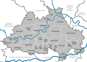
Eichstätt (German: Landkreis Eichstätt, Bavarian: Landkroas Eichstätt) is a Landkreis (district) in Bavaria, Germany.
The district is located in the southern part of the Frankish Alb. 80% of the district is in the Altmühltal Nature Park.
Towns and municipalities
[change | change source]
| Towns | Municipalities | |
|---|---|---|
References
[change | change source]- ↑ Genesis Online-Datenbank des Bayerischen Landesamtes für Statistik Tabelle 12411-003r Fortschreibung des Bevölkerungsstandes: Gemeinden, Stichtag (Einwohnerzahlen auf Grundlage des Zensus 2011) .
Wikimedia Commons has media related to Landkreis Eichstätt.


