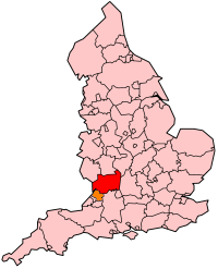
Gloucestershire
  | |

| |
| Geography | |
| Status | Ceremonial & (smaller) Non-metropolitan county |
|---|---|
| Origin | Historic |
| Region: | South West England |
| Area - Total - Admin. council - Admin. area |
Ranked 16th 3,150 km² Ranked 17th 2,653 km² |
| Admin HQ: | Gloucester |
| ISO 3166-2: | GB-GLS |
| ONS code: | 23 |
| NUTS 3: | UKK13 |
| Demographics | |
| Population - Total (2005 est.) - Density - Admin. council - Admin. pop. |
Ranked 25th 823,500 261 / km² Ranked 21st 575,400 |
| Ethnicity: | 97.3% White |
| Politics | |
Gloucestershire County Council http://www.gloucestershire.gov.uk/ Archived 2020-01-13 at the Wayback Machine | |
| Executive | Conservative |
| Members of Parliament | |
| Districts | |
Gloucestershire (pronounced [ˈglɒstəʃə]; GLOSS-ter-sher) is a county in South West England. The county includes part of the Cotswold Hills, part of the flat fertile valley of the River Severn, and the entire Forest of Dean.
The county town is Gloucester, and other principal towns include Cheltenham, Stroud, Cirencester, and Tewkesbury.
Gloucestershire borders the county of Gwent in Wales, and in England the counties of Herefordshire, Worcestershire, Warwickshire, Oxfordshire, Wiltshire, Somerset and Bristol.
Economy[change | change source]
This is a chart of trend of regional gross value added of Gloucestershire at current basic prices published (pp.240-253) by Office for National Statistics with figures in millions of British Pounds Sterling.
| Year | Regional Gross Value Added[1] | Agriculture[2] | Industry[3] | Services[4] |
|---|---|---|---|---|
| 1995 | 5,771 | 196 | 1,877 | 3,698 |
| 2000 | 8,163 | 148 | 2,677 | 5,338 |
| 2003 | 10,617 | 166 | 2,933 | 7,517 |
Antiquities and Other Places of interest[change | change source]
- Berkeley Castle, an example of a feudal stronghold.
- Beverston Castle
- Calcot Manor
- Forest of Dean
- Hailes Abbey
- Owlpen Manor
- Sudeley Castle
- Tewkesbury Abbey
- Tyndale Monument
- Wildfowl and Wetland Trust, Slimbridge
Other websites[change | change source]
- Gloucester County Official Site Archived 2020-01-13 at the Wayback Machine
- Gloucester City Council website
- Visit Gloucester Site
- Gloucester jobs
- Gloucestershire County Council Archived 2011-03-16 at the Wayback Machine
- Gloucestershire Tourism Partnership Archived 2021-01-19 at the Wayback Machine
- Official site for Cotswolds tourism
- Yate and Chipping Sodbury Guide Archived 2007-04-03 at the Wayback Machine - A Guide to Yate and Chipping Sodbury in South Gloucestershire
- Archaeological Handbook of Gloucestershire by George Witts
- Tales of the River Severn Archived 2020-10-31 at the Wayback Machine by Chris Witts
Wikimedia Commons has media related to Gloucestershire.

