Greenfield, Massachusetts
Appearance
Greenfield, Massachusetts | |
|---|---|
 The Civil War Memorial on Court Square | |
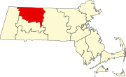
 Location in Franklin County in Massachusetts | |
| Coordinates: 42°35′15″N 72°36′00″W / 42.58750°N 72.60000°W | |
| Country | United States |
| State | Massachusetts |
| County | Franklin |
| Settled | 1686 |
| Incorporated | 1753 |
| Government | |
| • Type | Mayor-council city |
| Area | |
| • Total | 21.87 sq mi (56.65 km2) |
| • Land | 21.41 sq mi (55.46 km2) |
| • Water | 0.46 sq mi (1.19 km2) |
| Elevation | 302 ft (92 m) |
| Population | |
| • Total | 17,768 |
| • Density | 829.78/sq mi (320.39/km2) |
| Time zone | UTC−5 (Eastern) |
| • Summer (DST) | UTC−4 (Eastern) |
| ZIP Code | 01301 |
| Area code | 413 |
| FIPS code | 25-27060 |
| GNIS feature ID | 0618166[2] |
| Website | greenfield-ma |
Greenfield is a city in Franklin County, Massachusetts, United States. The population was 17,768 at the 2020 census.[3] It is the county seat of Franklin County.[4]
Greenfield was first settled in 1686.
References
[change | change source]- ↑ "2020 U.S. Gazetteer Files". United States Census Bureau. Retrieved May 21, 2022.
- ↑ 2.0 2.1 U.S. Geological Survey Geographic Names Information System: Greenfield, Massachusetts
- ↑ 3.0 3.1 "QuickFacts: Greenfield city, Massachusetts". United States Census Bureau. Retrieved March 4, 2024.
- ↑ National Association of Counties. "NACo County Explorer". Retrieved March 4, 2024.


