Hohenlinden
Hohenlinden | |
|---|---|
| Coordinates: 48°09′25″N 11°59′52″E / 48.15694°N 11.99778°E | |
| Country | Germany |
| State | Bavaria |
| Admin. region | Oberbayern |
| District | Ebersberg |
| Government | |
| • Mayor (2020–26) | Ludwig Maurer[1] |
| Area | |
| • Total | 17.32 km2 (6.69 sq mi) |
| Elevation | 540 m (1,770 ft) |
| Population (2022-12-31)[2] | |
| • Total | 3,383 |
| • Density | 200/km2 (510/sq mi) |
| Time zone | UTC+01:00 (CET) |
| • Summer (DST) | UTC+02:00 (CEST) |
| Postal codes | 85664 |
| Dialling codes | 08124 |
| Vehicle registration | EBE |
| Website | www.hohenlinden.de |
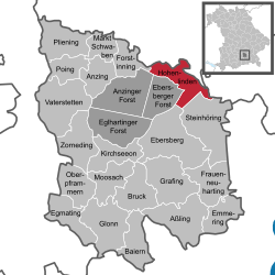
Hohenlinden (meaning "high linden trees";[a] colloquially: Linden; in the Bavarian dialect: Hea-lin) is a community in the Upper Bavarian district of Ebersberg. The city of Lynden, Washington is named after it, as is Linden, Alabama. Hohenlinden is also the subject of an eponymous poem by Thomas Campbell.
Geography[change | change source]
Hohenlinden is in the Munich Planning Region roughly 35 km east of Munich.
Hohenlinden has the following traditional rural land units (Gemarkungen in German): Ebersberger Forst and Hohenlinden.
References[change | change source]
- ↑ Liste der ersten Bürgermeister/Oberbürgermeister in kreisangehörigen Gemeinden, Bayerisches Landesamt für Statistik, accessed 19 July 2021.
- ↑ Genesis Online-Datenbank des Bayerischen Landesamtes für Statistik Tabelle 12411-003r Fortschreibung des Bevölkerungsstandes: Gemeinden, Stichtag (Einwohnerzahlen auf Grundlage des Zensus 2011) (Hilfe dazu).
- ↑ German hohe meaning "high", Linden meaning "linden trees" (singular: Linde)


