
Markt Schwaben
Markt Schwaben | |
|---|---|
 St. Margaret's Church (seen from the marketplace) | |
 Coat of arms | |
Location of Markt Schwaben within Ebersberg district  | |
 Markt Schwaben  Markt Schwaben | |
| Coordinates: 48°11′28″N 11°52′05″E / 48.19111°N 11.86806°E | |
| Country | Germany |
| State | Bavaria |
| Admin. region | Oberbayern |
| District | Ebersberg |
| Government | |
| • Mayor (2020–26) | Michael Stolze[1] |
| Area | |
| • Total | 10.87 km2 (4.20 sq mi) |
| Elevation | 509 m (1,670 ft) |
| Population (2022-12-31)[2] | |
| • Total | 13,853 |
| • Density | 1,300/km2 (3,300/sq mi) |
| Time zone | UTC+01:00 (CET) |
| • Summer (DST) | UTC+02:00 (CEST) |
| Postal codes | 85570 |
| Dialling codes | 08121 |
| Vehicle registration | EBE |
| Website | www.markt-schwaben.de |
Markt Schwaben is a town in Bavaria, Germany. It is about 23 km east of Munich on the northern edge of the Upper Bavarian district of Ebersberg. Neighbouring communities are Anzing, Forstinning, Pliening and Poing, (all in Ebersberg district) as well as Finsing, Ottenhofen and Pastetten (all in Erding district).
Geography
[change | change source]Through the town flows the Hennigbach, into which empties the Gigginger Bach southwest of Markt Schwaben. The River Sempt flows by to the east. The highest point in town is in the Wittelsbacher Höhe (heights) on the town's southern outskirts, which forms part of an alpine terminal moraine. Also in the south is the sport centre with its bathing pond. North of the railway tracks is the Burgerfeld new town with its theatre hall, more housing estates and several commercial-industrial areas. The castle with the town hall, the marketplace and St. Margaret's Church are downtown, and the school centre somewhat southwest of there.
Gallery
[change | change source]-
 The marketplace (towards the southwest)
 -
 Fountain at the market
 -
 Watertower
 -
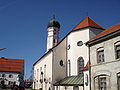 St.Margaret's (Erdinger Straße)
 -
 First World War memorial
 -
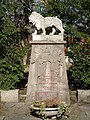 War memorial from 1900 with addition for Second World War
 -
 Old schoolhouse, Erdinger Straße
 -
 Old house in Drechslergasse.
 -
 Maibaum with German flag for European football championship final 2006


References
[change | change source]- ↑ Liste der ersten Bürgermeister/Oberbürgermeister in kreisangehörigen Gemeinden, Bayerisches Landesamt für Statistik, 15 July 2021.
- ↑ Genesis Online-Datenbank des Bayerischen Landesamtes für Statistik Tabelle 12411-003r Fortschreibung des Bevölkerungsstandes: Gemeinden, Stichtag (Einwohnerzahlen auf Grundlage des Zensus 2011) .
Other websites
[change | change source]Sources
[change | change source]Towns and municipalities in Ebersberg (district) | ||
|---|---|---|
| International | |
|---|---|
| National | |