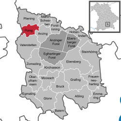
Poing, Bavaria
Poing | |
|---|---|
 Church of the Blessed Rupert Mayer | |
| Coordinates: 48°10′N 11°49′E / 48.167°N 11.817°E | |
| Country | Germany |
| State | Bavaria |
| Admin. region | Oberbayern |
| District | Ebersberg |
| Government | |
| • Mayor (2020–26) | Thomas Stark[1] (CSU) |
| Area | |
| • Total | 12.89 km2 (4.98 sq mi) |
| Elevation | 518 m (1,699 ft) |
| Population (2022-12-31)[2] | |
| • Total | 16,404 |
| • Density | 1,300/km2 (3,300/sq mi) |
| Time zone | UTC+01:00 (CET) |
| • Summer (DST) | UTC+02:00 (CEST) |
| Postal codes | 85586 |
| Dialling codes | 08121 |
| Vehicle registration | EBE |
Poing is a municipality in the Upper Bavarian district of Ebersberg, being 18 kilometres (11 mi) east of central Munich.
Geography[change | change source]
Poing is about 20 kilometres (12 mi) NE of Munich and is serviced by the Munich S-Bahn (S2) and MVV Bus systems. Poing has two constituent communities named Angelbrechting and Grub. Poing is bordered on the east by Anzing and Markt Schwaben, Pliening in the North, Kirchheim to the West and Parsdorf to the South.
References[change | change source]
- ↑ Liste der ersten Bürgermeister/Oberbürgermeister in kreisangehörigen Gemeinden, Bayerisches Landesamt für Statistik, accessed 19 July 2021.
- ↑ Genesis Online-Datenbank des Bayerischen Landesamtes für Statistik Tabelle 12411-003r Fortschreibung des Bevölkerungsstandes: Gemeinden, Stichtag (Einwohnerzahlen auf Grundlage des Zensus 2011)


