Misiones Department
Misiones
Departamento de Misiones | |
|---|---|
 Santiago church, Misiones | |
 Location of Misiones, in red, in Paraguay | |
| Coordinates: 26°38′S 57°10′W / 26.633°S 57.167°W | |
| Country | |
| Region | Oriental |
| Department | 1906 |
| Renamed | 1945 |
| Capital | San Juan Bautista |
| Districts | 10 (See list) |
| Government | |
| • Governor | Derlis Maidana Zarza |
| Area | |
| • Total | 9,556 km2 (3,690 sq mi) |
| Population (2013)[1] | |
| • Total | 119,719 |
| • Density | 13/km2 (32/sq mi) |
| Time zone | UTC-04 (AST) |
| • Summer (DST) | UTC-03 (ADT) |
| ISO 3166 code | PY-08 |
Misiones (Spanish: Departamento de Misiones) is a department in Paraguay. The capital is the city of San Juan Bautista. Its ISO 3166-2 code is PY-08.
Its present name was given to the province because it was a region where there were several Jesuit missions.
History[change | change source]
The town of Yabebyry was established in 1790, and later, the towns of San Miguel and San Juan Bautista were founded. In 1906, the Misiones department was created in 1906 as the San Ignacio department with 8 districts: San Ignacio, Santa Rosa, Santa María, Santiago, San Juan Bautista, San Miguel, Ayolas and Florida. When the department was renamed as Misiones in 1945, its capital was moved from San Ignacio to San Juan Bautista.
Geography[change | change source]
The Misiones department is in the south of the Oriental region. It has an area of 9,556 km2 (3,690 sq mi), 2.35% of the area of Paraguay. Its estimated population in 2013 is 119,719 for a population density of 12.5 inhabitants/km2.[1]
Misiones department is relatively flat and several rivers and streams flow through its territory. The northern and southern borders of the department are formed by, respectively, the Tebicuary and the Paraná rivers.
Limits[change | change source]
- To the north: Paraguarí and Caazapá departments.
- To the east: Itapúa department.
- To the south: Argentina.
- To the west: Ñeembucú department.
Climate[change | change source]
As of 2012[update], the total amount of precipitation for the year 2012 in the city of San Juan Bautista was 1,405.9 mm (55.4 in). The month with the most precipitation was April with 318.4 mm (12.5 in) of precipitation. The month with the least precipitation was June with 29.3 mm (1.2 in).[2]
The average temperature for the year 2012 in San Juan Bautista was 22.3 °C (72.1 °F). The warmest month, on average, was February with an average temperature of 28.4 °C (83.1 °F). The coolest month on average is July, with an average temperature of 14.6 °C (58.3 °F).[2]
Districts[change | change source]
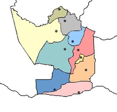
The department is divided in 22 districts:
| No. | Districts | Area (km²) |
Population[3] (2015) |
Density |
|---|---|---|---|---|
| 1 | Ayolas | 720.71 | 17,979 | 24.9 |
| 2 | San Ignacio | 1,550.47 | 32,792 | 21.1 |
| 3 | San Juan Bautista | 2,187.07 | 21,759 | 9.9 |
| 4 | San Miguel | 552.74 | 5,835 | 10.6 |
| 5 | San Patricio | 170.84 | 3,720 | 21.8 |
| 6 | Santa María | 457.80 | 8,594 | 18.8 |
| 7 | Santa Rosa | 724.70 | 18,372 | 25.4 |
| 8 | Santiago | 762.04 | 6,642 | 8.7 |
| 9 | Villa Florida | 278.75 | 3,370 | 12.1 |
| 10 | Yabebyry | 596.66 | 2,752 | 4.6 |
Economy[change | change source]
The basic economical activity of this department is cattle raising. As for agriculture, the fields are mainly in the north and center of the department.
Tourism[change | change source]
Its main attractions are the beaches formed by the rivers Paraná and Tebicuary. Villa Florida is a city which offers landscapes to its visitors.
Related pages[change | change source]
References[change | change source]
- ↑ 1.0 1.1 1.2 "Compendio Estadístico 2013" (PDF) (in Spanish). Dirección General de Estadísticas, Encuestas y Censos. Retrieved 14 November 2016.
- ↑ 2.0 2.1 "Compendio Estadístico Ambiental del Paraguay 2002-2012" (PDF) (in Spanish). Dirección General de Estadísticas, Encuestas y Censos. December 2013. Retrieved 14 December 2016.
- ↑ "Proyección de la población por sexo y edad, según distrito. Revisión 2015 (8.3 MB)" (PDF) (in Spanish). DGEEC. 2015. pp. 32–33. Retrieved 31 December 2016.
Other websites[change | change source]
- Statoids - Departments of Paraguay


