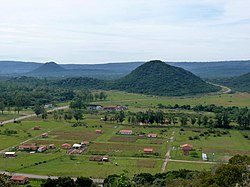
Paraguarí Department
Paraguarí
Departamento de Paraguarí | |
|---|---|
 | |
 Location of Paraguarí, in red, in Paraguay | |
| Coordinates: 25°38′S 57°9′W / 25.633°S 57.150°W | |
| Country | |
| Region | Oriental |
| Capital | Paraguarí |
| Boroughs | 17 (See list) |
| Government | |
| • Governor | Miguel Jorge Cuevas[1] |
| Area | |
| • Total | 8,705 km2 (3,361 sq mi) |
| Population (2012)[2] | |
| • Total | 239,633 |
| • Density | 28/km2 (71/sq mi) |
| Demonym | Paraguariense |
| Time zone | UTC-04 (AST) |
| • Summer (DST) | UTC-03 (ADT) |
| ISO 3166 code | PY-09 |
| Website | Official website |
The Paraguarí department (Spanish: Departamento de Paraguarí) is a department of Paraguay. The capital is the city of Paraguarí. Its ISO 3166-2 code is PY-09.
History[change | change source]
The territory of this department is in a valley formerly called "Yarigua'a" that was part of the mission of Jesuit priests during the colonization.
At the end of the 16th century, the Franciscan missionaries founded the city of Yaguarón with Guarani people. More towns were founded on which today form part of this department:
- Carapeguá (1725)
- Quiindy (1733)
- Ybycuí (1766)
- Pirayú (1769)
- Paraguarí (1775), the present capital of the department
- Quyquyhó (1776)
- Ybytimí and Acahay (1783)
- Caapucú (1787)
The department was created in 1935. In 1945, the old department of Quyyndy was made part of Paraguarí.
Geography[change | change source]
The Paraguarí department is in the southwest of the Oriental region. It is one of the smallest of the departments of Paraguay, with an area of 8,705 km2 (3,361 sq mi). It has a population of 239,633 for a population density of 27.5.[2]
Limits[change | change source]
- To the north: Cordillera and Caaguazú departments.
- To the east: Guairá and Caazapá departments.
- To the south: Misiones department.
- To the west: Ñeembucú and Central departments.
Districts[change | change source]
The department is divided in 17 districts:
| No. | Districts | Area[3] (km²) |
Population[4] (2002) |
Density |
|---|---|---|---|---|
| 1 | Acahay | 322 | 14,863 | 46.2 |
| 2 | Caapucú | 2,455 | 7,249 | 3.0 |
| 3 | Carapeguá | 462 | 30,758 | 66.6 |
| 4 | Escobar | 278 | 7,935 | 28.5 |
| 5 | General Bernardino Caballero | 245 | 6,449 | 26.3 |
| 6 | La Colmena | 99 | 5,234 | 52.9 |
| 7 | Mbuyapey | 898 | 13,035 | 14.5 |
| 8 | Paraguarí | 462 | 22,154 | 48.0 |
| 9 | Pirayú | 174 | 15,003 | 86.2 |
| 10 | Quiindy | 669 | 18,431 | 27.6 |
| 11 | Quyquyhó | 582 | 6,865 | 11.8 |
| 12 | San Roque González de Santa Cruz | 239 | 10,641 | 44.5 |
| 13 | Sapucai | 209 | 6,010 | 28.8 |
| 14 | Tebicuary-mí | 136 | 3,804 | 28.0 |
| 15 | Yaguarón | 232 | 25,984 | 112.0 |
| 16 | Ybycuí | 827 | 20,887 | 25.3 |
| 17 | Ybytymí | 389 | 6,630 | 17.0 |
Related pages[change | change source]
References[change | change source]
- ↑ "El Gobernador" (in Spanish). Gobernación de Paraguarí. Archived from the original on 7 September 2016. Retrieved 17 September 2016.
- ↑ 2.0 2.1 2.2 "Proyección Densidad Tasa 2012" (PDF) (in Spanish). Dirección General de Estadísticas, Encuestas y Censos. Retrieved 1 September 2016.
- ↑ "Territorio y Población" (zip) (in Spanish). ADEPO - Asociación Paraguaya de Estudios de Población. 2015. Retrieved 2 September 2016.
- ↑ "Districts of Paraguay". Statoids. Retrieved 18 September 2016.
Other websites[change | change source]
- Gobernación de Paraguarí website Archived 2016-09-07 at the Wayback Machine (in Spanish)
- Statoids - Departments of Paraguay
- Secretaria Nacional de Turismo


