Sonoma County, California
Sonoma County, California | |
|---|---|
| Motto(s): "Agriculture, Industry, Recreation" | |
 Interactive map of Sonoma County | |
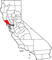
 Location in the state of California | |
| Coordinates: 38°31′N 122°56′W / 38.51°N 122.93°W | |
| Country | |
| State | |
| Region | San Francisco Bay Area |
| Incorporated | February 18, 1850[1] |
| Named for | the city of Sonoma |
| County seat (and largest city) | Santa Rosa |
| Government | |
| • Type | Council–Administrator |
| • Body | Sonoma County Board of Supervisors |
| Area | |
| • Total | 1,768 sq mi (4,580 km2) |
| • Land | 1,576 sq mi (4,080 km2) |
| • Water | 192 sq mi (500 km2) |
| Highest elevation | 4,483 ft (1,366 m) |
| Population | |
| • Total | 488,863 |
| • Density | 280/sq mi (110/km2) |
| Time zone | UTC−8 (Pacific Time Zone) |
| • Summer (DST) | UTC−7 (Pacific Daylight Time) |
| Area code | 707 |
| FIPS code | 06-097 |
| GNIS feature ID | 1657246 |
| Website | sonomacounty |
Sonoma County is a county in the U.S. state of California. It is located north of the San Francisco Bay. It is the northernmost of the nine San Francisco Bay Area counties.[4][5] Sonoma County is surrounded by 4 counties: Marin County to the south, Mendocino County to the north, Lake County to the northeast, and Napa County to the east.[6] The county seat is in Santa Rosa.
Sonoma County was one of the original counties formed when California became a state in 1850.[7]
The population was 488,863 in 2020.[3]
Cities[change | change source]
Some of the cities in Sonoma County[8] include:
Related pages[change | change source]
References[change | change source]
- ↑ "Chronology". California State Association of Counties. Archived from the original on January 29, 2016. Retrieved February 6, 2015.
- ↑ "Cobb Mountain-Southwest Peak". Peakbagger.com. Retrieved February 4, 2015.
- ↑ 3.0 3.1 "QuickFacts: Sonoma County, California". U.S. Census Bureau. Retrieved May 10, 2023.
- ↑ "San Francisco Bay Area Vision Project". Bayareavision.org. Archived from the original on October 29, 2013. Retrieved November 4, 2011.
- ↑ "The Association of Bay Area Governments". Abag.ca.gov. April 14, 2011. Retrieved November 4, 2011.
- ↑ "California County Map". CSAC.org. California State Association of Counties. 2014. Retrieved 2015-09-22.
- ↑ "California County History". CSAC.org. California State Association of Counties. 2014. Retrieved 2015-09-22.
- ↑ "Cities of Sonoma County". sonomacounty.com. Sonoma County Tourism. 2015. Retrieved 2015-09-22.
Other websites[change | change source]
 Media related to Sonoma County, California at Wikimedia Commons
- Sonoma County Official Website


