
Vienne (river)
| Vienne Vinhana (Occitan) | |
|---|---|
 The Vienne in Limoges | |
.png) | |
| Location | |
| Country | France |
| Physical characteristics | |
| Source | |
| - location | Plateau de Millevaches |
| - elevation | 880 m (2,890 ft) |
| Mouth | |
| - location | Loire |
| - coordinates | 47°12′45″N 0°4′31″E / 47.21250°N 0.07528°E |
| Length | 363 km (226 mi) |
| Basin size | 21,105 km2 (8,149 sq mi) |
| Discharge | |
| - average | 203 m3/s (7,200 cu ft/s) |
| Basin features | |
| Progression | Loire→ Atlantic Ocean |
The Vienne (Occitan: Vinhana) is one of the most important rivers in southwestern France, a main left tributary of the lower Loire river. It supports numerous hydroelectric dams.
It flows through the Nouvelle-Aquitaine and Centre-Val de Loire regions, and two French départements are named after the Vienne: the Haute-Vienne (87) and the Vienne (86).
Geography[change | change source]
The Vienne river has a length of 363.2 km (226 mi) and a drainage basin with an area of approximately 21,161 km2 (8,170 sq mi).[1]
Course[change | change source]
The Vienne river starts in the department of the Corrèze, at the foot of Mont Audouze, on the Plateau de Millevaches, in the commune of Millevaches, at an elevation of about 880 m (2,887 ft).[2]
It then flows roughly west to the city of Limoges where its water was used in the famous Limoges porcelain industry. A little way after Limoges it takes a turn to the north.
Finally, the river flows into the Loire river, on the left side, in the commune Candes-Saint-Martin.[3]
The Vienne flows through 6 departments and 96 communes, in 2 regions:[1]
- Centre-Val de Loire region
- Nouvelle-Aquitaine region
The Vienne flows through three regional nature parks: Parc naturel régional de Millevaches en Limousin, Parc naturel régional Périgord Limousin and Parc naturel régional Loire-Anjou-Touraine.
Main tributaries[change | change source]
The main tributaries of the Vienne river are:[1]
|
Left tributaries:
|
|
Right tributaries:
|
Hydrology[change | change source]
Its average yearly discharge (volume of water which passes through a section of the river per unit of time) is 193.0 m3/s (6,820 cu ft/s) at Nouâtre in the Indre-et-Loire department.[4]
Average monthly discharge (m3/s) at Nouâtre (1958 - 2017)[4]

Gallery[change | change source]
-
 The source of Vienne near Saint-Setiers.
 -
 The Vienne near Peyrelevade.
 -
 The Vienne in Chinon.
 -
 The Vienne in Aixe-sur-Vienne (Haute-Vienne).
 -
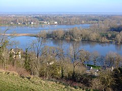 Confluence with the Loire river, the Vienne in front.


.JPG)

Related pages[change | change source]
References[change | change source]
- ↑ 1.0 1.1 1.2 "La Vienne (L---0060)" (in French). SANDRE - Portail national d'accès aux référentiels sur l'eau. Archived from the original on 9 November 2014. Retrieved 31 July 2016.
- ↑ "Source de la Vienne" (in French). Géoportail. Retrieved 31 July 2016.[permanent dead link]
- ↑ "Confluence de la Vienne" (in French). Géoportail. Retrieved 31 July 2016.[permanent dead link]
- ↑ 4.0 4.1 "La Vienne à Nouâtre" (in French). Banque Hydro. Archived from the original on 2 February 2019. Retrieved 2 December 2017.
Other websites[change | change source]
- Banque Hydro - Station L7000610 - La Vienne à Nouâtre Archived 2015-02-19 at the Wayback Machine (in French)