
Balkhash (city)
Balkhash
Балқаш (Kazakh) | |
|---|---|
 Independence Square | |
 Coat of arms | |
| Etymology: Turkic: balkaš (marshland) | |
 Balkhash Location in Kazakhstan  Balkhash Balkhash (Asia) | |
| Coordinates: 46°50′53″N 74°59′42″E / 46.84806°N 74.99500°E | |
| Country | |
| Region | Karaganda Region |
| Founded | 1931 (as Pribalkhashstroi) |
| Incorporated (city) | April 11, 1937 |
| Government | |
| • Akim (mayor) | Sapar Satayev[1] |
| Area | |
| • City | 230 km2 (90 sq mi) |
| • Land | 5,951 km2 (2,298 sq mi) |
| Elevation | 440 m (1,440 ft) |
| Population (2023) | |
| • City | 73,739 |
| • Rank | 20th |
| • Density | 320/km2 (830/sq mi) |
| • Urban | 77,878 |
| Time zone | GMT+6 |
| • Summer (DST) | UTC+6 (UTC+6) |
| Postal code | 100300 - 100316 |
| Area code | +7 71036 |
| Website | balkhash |
Balkhash (Kazakh: Балқаш; Russian: Балхаш, romanized: Balkhash) is a city in the Qaraghandy Region of Kazakhstan, it is on the shore of Lake Balqash. It has a population of almost 78,000 people (as of 2023).[2] Previously, the name of the city was Pribalkhashstroi (Russian: Прибалхашстрой).
The city area also includes four settlements: Gulshat, Sayak, Saryshagan and Shashubai.
History[change | change source]
Early history[change | change source]
Copper was found the area in 1928. This led to the city being built. Small settlements for workers were built around the Balkhash mining and metallurgical plant.
On April 11, 1937, Balkhash became a city. The plan of the city was designed by the Leningrad Research and Design Institute of Urban Planning.[3] People from all over the Soviet Union took part in the construction of the city and the copper plant. The Balkhash construction project was then called the “Balkhash Giant”, and it was prestigious to work on the construction. This can be confirmed by the words of the first secretary of the Communist Party of the Kazakh SSR, Levon Mirzoyan:
“Years will pass, the construction of the Balkhash giant will end, and a person who says that he spent five years on this construction site will be treated with great respect. Anyone who works on Balkhash , earns an honorable position in the country".[4]
On January 12, 1936, the first house with a large number of floors for living was built in the city. A significant part of the workers moved to comfortable apartments.
For the period from 1938 to 1941, the government invested 550 million Soviet rubles in the construction of the city, of which 122 millions were for the construction of houses for living.[5] The city began to develop very fast.
In the 1940s, about 40,000 people lived in this city.[6] There was a copper factory and the Kounrad mine, a meat processing plant, a bread factory, fishing companies, and a beer production plant. Much attention was paid to the development of agriculture and gardening. There were no universities, but there were 2 technical schools and 5 secondary and 10 primary schools. In total, about 2000 people studied there. There was a newspaper "Balkhash Worker" in two languages. Several bus routes were opened throughout the city.
Great Patriotic War[change | change source]
On June 22, 1941, Nazi Germany invaded the territory of the USSR, this became the beginning of the Great Patriotic War.
During the Great Patriotic War (the Russian name for World War II), most of the men went to war and women replaced them at the copper factory. 11,532 people of Balkhash fought during the war.[7]
A system of distributing goods by cards was introduced. There was a shortage of goods in the country. Residents of the city were given cards for bread, sugar and other goods. Workshop managers were required to work at full productivity and use the patriotic desires of the workers.
Post-war time[change | change source]
After the war, Japanese prisoners of war constructed the city. For example, they built the buildings of the Palace of Metallurgists and the airport.
In April 1987, the city was awarded the Order of Friendship of Peoples (en).[7]
In the end of the 1990s, the situation in the city (as well as in the country’s economy) stabilized. Schools, clinics, and technical schools started to work stably.
Geography[change | change source]
The city is located on the northern coast of the Lake Balkash.
The city is located about 500 km west of the border with China and about 300 km south of Qaraghandy, the administrative center of the region.
70 kilometers north of Balkhash is the mountainous area of Bektau-Ata. The highest point is 1213 m above sea level.
Balkhash has a continental climate. Winters here are very cold and summers are very hot. The average annual temperature in the city is 6.3 °C (43.3 °F).
The average winter temperature is -11.7 °C (10.7 °F) and the average summer temperature is 22.9 °C (73.2 °F):
| Climate data for Balkhash | |||||||||||||
|---|---|---|---|---|---|---|---|---|---|---|---|---|---|
| Month | Jan | Feb | Mar | Apr | May | Jun | Jul | Aug | Sep | Oct | Nov | Dec | Year |
| Record high °C (°F) | 3.9 (39.0) |
6.1 (43.0) |
24.5 (76.1) |
32.5 (90.5) |
36.5 (97.7) |
38.2 (100.8) |
40.9 (105.6) |
39.5 (103.1) |
37.6 (99.7) |
27.2 (81.0) |
17.4 (63.3) |
7.5 (45.5) |
40.9 (105.6) |
| Average high °C (°F) | −9.0 (15.8) |
−6.4 (20.5) |
2.7 (36.9) |
14.7 (58.5) |
22.1 (71.8) |
27.8 (82.0) |
29.3 (84.7) |
28.1 (82.6) |
21.5 (70.7) |
13.2 (55.8) |
2.8 (37.0) |
−5.4 (22.3) |
11.8 (53.2) |
| Daily mean °C (°F) | −13.6 (7.5) |
−11.6 (11.1) |
−2.7 (27.1) |
9.0 (48.2) |
16.5 (61.7) |
22.5 (72.5) |
24.1 (75.4) |
22.5 (72.5) |
15.6 (60.1) |
7.5 (45.5) |
−1.9 (28.6) |
−9.9 (14.2) |
6.5 (43.7) |
| Average low °C (°F) | −17.9 (−0.2) |
−16.3 (2.7) |
−7.2 (19.0) |
3.8 (38.8) |
10.6 (51.1) |
16.7 (62.1) |
18.4 (65.1) |
16.5 (61.7) |
9.4 (48.9) |
2.3 (36.1) |
−5.9 (21.4) |
−13.9 (7.0) |
1.4 (34.5) |
| Record low °C (°F) | −40.1 (−40.2) |
−40.2 (−40.4) |
−30.8 (−23.4) |
−14.2 (6.4) |
−5.5 (22.1) |
3.9 (39.0) |
6.9 (44.4) |
3.7 (38.7) |
−4.7 (23.5) |
−15.0 (5.0) |
−32.7 (−26.9) |
−41.2 (−42.2) |
−41.2 (−42.2) |
| Average precipitation mm (inches) | 14 (0.6) |
12 (0.5) |
13 (0.5) |
10 (0.4) |
14 (0.6) |
13 (0.5) |
15 (0.6) |
7 (0.3) |
3 (0.1) |
9 (0.4) |
17 (0.7) |
14 (0.6) |
141 (5.6) |
| Average rainy days | 2 | 2 | 5 | 7 | 9 | 8 | 9 | 6 | 4 | 7 | 7 | 4 | 70 |
| Average snowy days | 15 | 14 | 7 | 1 | 0.1 | 0 | 0 | 0 | 0 | 1 | 8 | 15 | 61 |
| Average relative humidity (%) | 79 | 78 | 74 | 56 | 51 | 46 | 49 | 47 | 47 | 60 | 75 | 79 | 62 |
| Mean monthly sunshine hours | 153 | 179 | 228 | 276 | 335 | 367 | 377 | 363 | 299 | 222 | 151 | 131 | 3,081 |
| Source 1: pogoda.ru.net[8] | |||||||||||||
| Source 2: NOAA (sun only, 1961–1990)[9] | |||||||||||||
Population[change | change source]
The population was highest in 1989, when 100,533 people lived in the city.[10]
As of 2023, there are 73739 people living in Balkhash and 77787 people are living in the urban area of the city. The population density is 320 people per km².
| Year | 1959[11] | 1970[12] | 1979[13] | 1989[14][15] | 1999[16] | 2009[16] | 2012[17] |
|---|---|---|---|---|---|---|---|
| Population | 53,031 | 75,965 | 78,145 | 86,609 | 65,431 | 68,833 | 70,305 |
People of more than 60 nationalities live in Balkhash. This is because when the city was built, people came here from all over the Soviet Union. Also in the 30-40s, some peoples who were repressed were brought here.[18]
Nationalities including the population of city area settlements (as of the beginning of 2021):[19]
| Ethnicity | Population | Percentage |
|---|---|---|
| Kazakhs | 56,411 | 72,00 % |
| Russians | 19,132 | 22,30 % |
| Koreans | 1,014 | 1,32 % |
| Germans | 922 | 1,23 % |
| Tatars | 887 | 1,05 % |
| Ukrainians | 501 | 0,75 % |
| Uzbeks | 197 | 0,25 % |
| Chechens | 164 | 0,20 % |
| Azerbaijanis | 135 | 0,17 % |
| Belarusians | 87 | 0,13 % |
| others | 993 | 1,27 % |
| Total | 80,136 | 100,00 % |
Most of the city's people are Muslim Kazakhs. There is a central mosque in the city under the control of the Spiritual Administration of Muslims of Kazakhstan.
There is also a Russian Orthodox Church and a Catholic Church in the city.
Economy[change | change source]
In 2023, the city received 7.4 trillion tenge in taxes.[20]
Balkhash is an important transit city linking Almaty and Astana, the country's two largest cities.
Balkhash is one of the most important centers of metallurgy in Kazakhstan. A large copper area, discovered in 1928-30, is being mined in villages north of the lake, such as Konyrat and Sayak. From there, copper is transported to the Balkhash plant.
In 1967, at the London International Exhibition, Balkhash copper was recognized as the world standard of copper.
Popular recreational activities on Lake Balkhash are beach tourism and water sports: sailing, kayaking and canoeing, and sport fishing.
Gallery[change | change source]
-
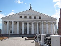 Palace of Culture
 -
-
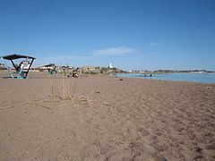 City Beach
 -
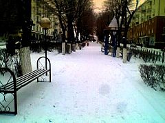 Winter in Balkhash
 -
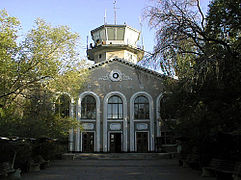
 Metallurgical plant
 -
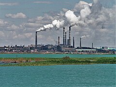
 The depth of the city of Balkhash. A lake and a copper plant are visible in the background.


References[change | change source]
- ↑ "Сапар Сатаев назначен акимом Балхаша". kt.kz. 2023-05-10.
- ↑ "Population of the Republic of Kazakhstan by gender and type of area (as of 2023-01-01)". QazStat. 2023-01-01. Archived from the original on 2023-03-05.
- ↑ Tukbaeva, Lyudmila (2017-04-07). "Время требовало полной отдачи" [The time required full dedication]. Газета "Северное Прибалхашье" [Newspaper "Northern Balkhash"] (in Russian): 1 – via CENTRALIZED LIBRARY SYSTEM OF THE CITY OF BALKHASH.
- ↑ "Летопись города" [Chronicle of the city]. Северное Прибалхашье [North Balkhash] (in Russian). 2017-03-29. p. 1. Retrieved 2023-11-25.
- ↑ Dubrovin, A. (1938-11-27). "Первая балхашская медь" [First Balkhash copper] (PDF). Pravda (in Russian). No. № 326 (1851). Soviet Union: Central Committee of the All-Union Communist Party (bolsheviks). p. 6. Retrieved 2023-11-21.
{{cite news}}:|issue=has extra text (help) - ↑ "From the history of the city of Balkhash". State archive of the city of Balkhash. 2020-02-27. Retrieved 2023-10-28.
- ↑ 7.0 7.1 Kaukerbek, S. (2017-02-03). "The pride of Balkhash residents: for the 80th anniversary of the city". "Pulse" newspaper. №5: 2p.
{{cite journal}}:|volume=has extra text (help) - ↑ "pogoda.ru.net Погода и Климат" (in Russian). Retrieved 2023-11-12.
- ↑ "Balkhash Climate Normals 1961-1990". National Oceanic and Atmospheric Administration. Retrieved 2023-11-12.
- ↑ "Всесоюзная перепись населения 1989 г." [All-Union Population Census 1989]. Демоскоп Weekly (Demoscope Weekly) (in Russian). Archived from the original on 2014-12-22. Retrieved 2023-11-20.
- ↑ Демоскоп Weekly, demoscope.ru. "Vsesojuznaja perepis naselenija 1959 g. (krome RSFSR)". demoscope.ru (in Russian). Retrieved 2023-11-12.
- ↑ Демоскоп Weekly, demoscope.ru. "Vsesojuznaja perepis naselenija 1970 g. (krome RSFSR)". demoscope.ru (in Russian). Retrieved 2023-11-12.
- ↑ Демоскоп Weekly, demoscope.ru. "Vsesojuznaja perepis naselenija 1979 g. (krome RSFSR)". demoscope.ru (in Russian). Retrieved 2023-11-12.
- ↑ demoscope.ru (2009). "Protsessy urbanizantsii v Kazahstane v postsovetski period i ih demografitšeskaja sosravljuštšaja" (in Russian). Retrieved 2023-11-12.
- ↑ Демоскоп Weekly, demoscope.ru. "Vsesojuznaja perepis naselenija 1989 g. Gorodskoi". demoscope.ru (in Russian). Retrieved 2023-11-12.
- ↑ 16.0 16.1 Agenstvo Respubliki Kazahstan po statistike, www.stat.gov.kz (2011). "Portret goroda. Itogi Natsionalnoi perepisi naselenija Respubliki Kazahstan 2009 goda" (PDF) (in Russian). Archived from the original (PDF) on 2013-10-14. Retrieved 2023-11-12.
- ↑ Қазақстан Республикасы Статистика агенттігі, www.stat.gov.kz (2012). "ҚАЗАҚСТАННЫҢ ДЕМОГРАФИЯЛЫҚ ЖЫЛНАМАЛЫҒЫ - ДЕМОГРАФИЧЕСКИЙ ЕЖЕГОДНИК КАЗАХСТАНА" (PDF) (in Kazakh). Archived from the original (PDF) on 2013-09-21. Retrieved 2015-01-05.
- ↑ "The city of Balkhash is 80 years old!". EDUCATION DEPARTMENT OF THE CITY OF BALKHASH. 2013. Retrieved 2023-11-14.
- ↑ ""Population of Kazakhstan by separate ethnic groups at the beginning of 2021". QazStat (in Russian). Archived from the original on 2021-05-02. Retrieved 2021-05-01.
- ↑ "Execution of the budget of the city of Balkhash as of November 1, 2023". Department of Economics and Finance of the city of Balkhash. 2023-11-03. Retrieved 2023-11-17.