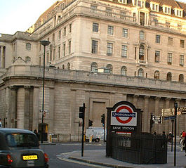
Bank and Monument stations
| Bank & Monument | |
|---|---|
 Bank | |
| Location | King William Street |
| Local authority | City of London |
| Managed by | London Underground |
| Number of platforms | 10 |
| Fare zone | 1 |
| London Underground annual entry and exit | |
| 2005 | 34.295 million |
| 2006 | 38.209 million |
| 2007 | 41.883 million[1] |
| 2008 | 42.82 million[1] |
| Key dates | |
| 1884 1898 1900 1900 1991 | Opened (MICCR) Opened (W&CR) Opened (C&SLR) Opened (CLR) Opened (DLR) |
| Other information | |
Bank and Monument are interlinked stations, officially one station known operationally as the "Bank-Monument complex". However, separate names are used on station entrances, platforms and the tube map. The complex spans the length of King William Street in the City of London. Together they form the eighth busiest station on the network, being served by five London Underground lines and the Docklands Light Railway (DLR). The two parts of the combined station take their names from the nearby Bank of England and the Monument to the Great Fire of London. The complex is in Travelcard Zone 1.
Bus connections
[change | change source]London Buses routes 8, 11, 21, 23, 25, 26, 40, 43, 76, 133, 141, 242 and 388 and night bus routes N8, N11, N21, N26, N76, N133, N550 and N551 serve the station.
Gallery
[change | change source]-
Circle & District Line platforms at Monument looking west
-
Northbound Northern Line platform at Bank
-
Docklands Light Railway platform at Bank
-
Roundel on Bank Central line eastbound platform
Related pages
[change | change source]References
[change | change source]- ↑ 1.0 1.1 "Multi-year station entry-and-exit figures (2007–2017)". London Underground station passenger usage data. Transport for London. January 2018. Archived from the original (XLSX) on 31 July 2018. Retrieved 22 July 2018. Cite error: Invalid
<ref>tag; name "infobox_stats_ref_tube_2007" defined multiple times with different content
Other websites
[change | change source]- A diagram of the Bank/Monument station complex Archived 2016-04-18 at the Wayback Machine
- Another diagram (in colour) Archived 2016-04-18 at the Wayback Machine
- Bank Station Archived 2005-04-22 at the Wayback Machine from the Open Guide to London
- History of Bank station, including a picture just after the 1941 bomb Archived 2016-04-18 at the Wayback Machine
- London Transport Museum Photographic Archive Archived 2012-02-14 at the Wayback Machine
- C&SLR Lombard Street entrance in front of St Mary Woolnoth, 1914
- C&SLR King William Street entrance in front of St Mary Woolnoth, 1914
- Entrances in front of Royal Exchange, 1914
- Entrance in front of Royal Exchange, 1923
- Ticket hall showing steel support structure and tops of escalators, 1925
- Ticket hall, 1933
- View of bomb crater, January 1941
- More photographs of Bank station
| Bank | ||||
| Preceding station | Following station | |||
|---|---|---|---|---|
towards Ealing Broadway or West Ruislip | Central line | |||
| Northern line | towards Morden |
|||
Terminus | Waterloo & City line | Terminus | ||
| Terminus | Docklands Light Railway | |||
| Monument | ||||
| Preceding station | Following station | |||
towards Hammersmith | Circle line | towards Edgware Road |
||
| District line | towards Upminster |
|||


