Jump to content

Counties of Croatia

From Simple English Wikipedia, the free encyclopedia
Counties of Croatia
Hrvatske županije (Croatian)
Map of moderncounties of Croatia
Counties of Croatia:   Bjelovar-Bilogora   Brod-Posavina   Dubrovnik-Neretva   Istria   Karlovac   Koprivnica-Križevci   Krapina-Zagorje   Lika-Senj   Međimurje   Osijek-Baranja   Požega-Slavonia   Primorje-Gorski Kotar   Šibenik-Knin   Sisak-Moslavina   Split-Dalmatia   Varaždin   Virovitica-Podravina   Vukovar-Srijem   Zadar   City of Zagreb   Zagreb County
CategoryUnitary state
LocationRepublic of Croatia
Number20 counties + Zagreb city
Populations50,927 (Lika-Senj) – 790,017 (Zagreb)
Areas640 km2 (247 sq mi) (Zagreb) – 5,350 km2 (2,067 sq mi) (Lika-Senj)
GovernmentCounty government, National government
SubdivisionsMunicipality and City

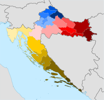
The counties of Croatia (Croatian: županije) are the first-level administrative divisions of the Republic of Croatia.[1] Croatia is divided into 20 counties and the capital city of Zagreb, which is both a county and a city. It is separate from Zagreb County.[2][3] The counties are divided into 128 cities and 428 municipalities.[4][5]

The counties are governed by county assemblies (Croatian: županijska skupština). Members of the county assembly are elected for a four-year term.[6]

List of counties

[change | change source]
Counties of Croatia as defined in 2006
CountySeatArea[7]Population (2011)[7]GDP per capita (2013)[8]ArmsGeographic coordinates
Bjelovar-Bilogora Bjelovar2,640 km2 (1,020 sq mi)119,764€6,838Coat of arms of Bjelovar-Bilogora County45°54′10″N 16°50′51″E / 45.90278°N 16.84750°E / 45.90278; 16.84750 (Bjelovar-Bilogora County)
Brod-Posavina Slavonski Brod2,030 km2 (780 sq mi)158,575€5,858Coat of arms of Brod-Posavina County45°09′27″N 18°01′13″E / 45.15750°N 18.02028°E / 45.15750; 18.02028 (Brod-Posavina County)
Dubrovnik-Neretva Dubrovnik1,781 km2 (688 sq mi)122,568€9,969Coat of arms of Dubrovnik-Neretva County42°39′13″N 18°05′41″E / 42.65361°N 18.09472°E / 42.65361; 18.09472 (Dubrovnik-Neretva County)
Istria Pazin2,813 km2 (1,086 sq mi)208,055€12,711Coat of arms of Istria County45°14′21″N 13°56′19″E / 45.23917°N 13.93861°E / 45.23917; 13.93861 (Istria County)
Karlovac Karlovac3,626 km2 (1,400 sq mi)128,899€7,763Coat of arms of Karlovac County45°29′35″N 15°33′21″E / 45.49306°N 15.55583°E / 45.49306; 15.55583 (Karlovac County)
Koprivnica-Križevci Koprivnica1,748 km2 (675 sq mi)115,584€8,768Coat of arms of Koprivnica-Križevci County46°10′12″N 16°54′33″E / 46.17000°N 16.90917°E / 46.17000; 16.90917 (Koprivnica-Križevci County)
Krapina-Zagorje Krapina1,229 km2 (475 sq mi)132,892€6,380Coat of arms of Krapina-Zagorje County46°7′30″N 15°48′25″E / 46.12500°N 15.80694°E / 46.12500; 15.80694 (Krapina-Zagorje County)
Lika-Senj Gospić5,353 km2 (2,067 sq mi)50,927€7,841Coat of arms of Lika-Senj County44°42′25″N 15°10′27″E / 44.70694°N 15.17417°E / 44.70694; 15.17417 (Lika-Senj County)
Međimurje Čakovec729 km2 (281 sq mi)113,804€8,481Coat of arms of Međimurje County46°27′58″N 16°24′50″E / 46.46611°N 16.41389°E / 46.46611; 16.41389 (Međimurje County)
Osijek-Baranja Osijek4,155 km2 (1,604 sq mi)305,032€8,121Coat of arms of Osijek-Baranja County45°38′13″N 18°37′5″E / 45.63694°N 18.61806°E / 45.63694; 18.61806 (Osijek-Baranja County)
Požega-Slavonia Požega1,823 km2 (704 sq mi)78,034€6,102Coat of arms of Požega-Slavonia County45°18′40″N 17°44′24″E / 45.31111°N 17.74000°E / 45.31111; 17.74000 (Požega-Slavonia County)
Primorje-Gorski Kotar Rijeka3,588 km2 (1,385 sq mi)296,195€12,930Coat of arms of Primorje-Gorski Kotar County45°27′14″N 14°35′38″E / 45.45389°N 14.59389°E / 45.45389; 14.59389 (Primorje-Gorski Kotar County)
Šibenik-Knin Šibenik2,984 km2 (1,152 sq mi)109,375€8,051Coat of arms of Šibenik-Knin County43°55′44″N 16°3′43″E / 43.92889°N 16.06194°E / 43.92889; 16.06194 (Šibenik-Knin County)
Sisak-Moslavina Sisak4,468 km2 (1,725 sq mi)172,439€7,842Coat of arms of Sisak-Moslavina County45°13′15″N 16°15′5″E / 45.22083°N 16.25139°E / 45.22083; 16.25139 (Sisak-Moslavina County)
Split-Dalmatia Split4,540 km2 (1,750 sq mi)454,798€7,849Coat of arms of Split-Dalmatia County43°10′0″N 16°30′0″E / 43.16667°N 16.50000°E / 43.16667; 16.50000 (Split-Dalmatia County)
Varaždin Varaždin1,262 km2 (487 sq mi)175,951€8,415Post-1992 coat of arms of Varaždin County46°19′16″N 16°13′52″E / 46.32111°N 16.23111°E / 46.32111; 16.23111 (Varaždin County)
Virovitica-Podravina Virovitica2,024 km2 (781 sq mi)84,836€6,043Coat of arms of Virovitica-Podravina County45°52′23″N 17°30′18″E / 45.87306°N 17.50500°E / 45.87306; 17.50500 (Virovitica-Podravina County)
Vukovar-Srijem Vukovar2,454 km2 (947 sq mi)179,521€6,025Coat of arms of Vukovar-Srijem County45°13′43″N 18°55′0″E / 45.22861°N 18.91667°E / 45.22861; 18.91667 (Vukovar-Srijem County)
Zadar Zadar3,646 km2 (1,408 sq mi)170,017€8,173Coat of arms of Zadar County44°1′5″N 15°53′42″E / 44.01806°N 15.89500°E / 44.01806; 15.89500 (Zadar County)
Zagreb County Zagreb3,060 km2 (1,180 sq mi)317,606€7,781Post-1992 coat of arms of Zagreb County45°44′56″N 15°34′16″E / 45.74889°N 15.57111°E / 45.74889; 15.57111 (Zagreb County)
City of Zagreb Zagreb641 km2 (247 sq mi)790,017€18,132Coat of arms of the city of Zagreb45°49′0″N 15°59′0″E / 45.81667°N 15.98333°E / 45.81667; 15.98333 (City of Zagreb)

References

[change | change source]
  1. The Constitution of the Republic of Croatia (consolidated text) - Croatian Parliament Archived 2015-11-02 at the Wayback Machine.Retrieved 5 October 2016.
  2. "Gospodarski profil Grada Zagreba i Zagrebačke županije" [Economic profile of the City of Zagreb and the Zagreb County] (in Croatian). Croatian Chamber of Economy. Archived from the original on 7 May 2006. Retrieved 6 May 2012.
  3. "Zakon o područjima županija, gradova i općina u Republici Hrvatskoj" [Territories of Counties, Cities and Municipalities of the Republic of Croatia Act]. Narodne novine (in Croatian). 30 January 1997. Retrieved 6 May 2012.
  4. "Zakon o područjima županija, gradova i općina u Republici Hrvatskoj" [Territories of Counties, Cities and Municipalities of the Republic of Croatia Act]. Narodne novine (in Croatian). 28 July 2006. Retrieved 9 September 2011.
  5. "Popovača dobila status grada". Poslovni dnevnik (in Croatian). 12 April 2013. Retrieved 27 January 2014.
  6. "Zakon o lokalnim izborima" [Local Elections Act]. Narodne novine (in Croatian). No. 144/2012. 21 December 2012. Retrieved 5 October 2016.
  7. 1 2 "Counties, surface area, population, towns, municipalities and settlements, 2011 census". Croatian Bureau of Statistics. Archived from the original on 7 January 2019. Retrieved 17 December 2012.
  8. "Gross domestic product for Republic of Croatia, statistical regions at level 2 and counties, 2011". Croatian Bureau of Statistics. 14 February 2014. Archived from the original on 27 January 2022. Retrieved 14 July 2015.