Vukovar-Srijem County
Vukovar-Srijem County
Vukovarsko-srijemska županija | |
|---|---|
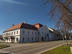
 "Županija Palace" of Vukovar-Srijem County in Vukovar | |
 Vukovar-Srijem County within Croatia | |
| Country | Croatia |
| County seat | Vukovar |
| Area | |
| • Total | 2,454 km2 (947 sq mi) |
| Elevation | 78−224 m (255−734 ft) |
| Population (2011) | |
| • Total | 180,117 |
| • Density | 73/km2 (190/sq mi) |
| Postal code | |
| Area code | 32 |
| ISO 3166 code | HR-16 |
| Vehicle registration | VK, VU, ŽU |
| Website | Official site |
Vukovar-Srijem County is the easternmost Croatian county. The county seat is Vukovar. The biggest town is Vinkovci. Other towns are Ilok, Otok and Županja.
References[change | change source]
- ↑ Ostroški, Ljiljana, ed. (December 2015). Statistički ljetopis Republike Hrvatske 2015 [Statistical Yearbook of the Republic of Croatia 2015] (PDF). Statistical Yearbook of the Republic of Croatia (in Croatian and English). Vol. 47. Zagreb: Croatian Bureau of Statistics. p. 62. ISSN 1333-3305. Retrieved 27 December 2015.
Wikimedia Commons has media related to Vukovar-Syrmia County.


