Nash County, North Carolina
Nash County | |
|---|---|
 Nash County Courthouse in Nashville | |
| Motto: "Where Business meets Opportunity" | |
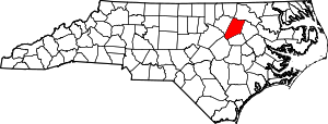
 Location within the U.S. state of North Carolina | |
 North Carolina's location within the U.S. | |
| Coordinates: 35°57′57″N 77°59′15″W / 35.965945°N 77.987555°W | |
| Country | |
| State | |
| Founded | 1777 |
| Named for | Francis Nash |
| Seat | Nashville |
| Largest community | Rocky Mount |
| Area | |
| • Total | 542.82 sq mi (1,405.9 km2) |
| • Land | 540.44 sq mi (1,399.7 km2) |
| • Water | 2.38 sq mi (6.2 km2) 0.44% |
| Population (2020) | |
| • Total | 94,970 |
| • Density | 175.73/sq mi (67.85/km2) |
| Time zone | UTC−5 (Eastern) |
| • Summer (DST) | UTC−4 (EDT) |
| Congressional district | 1st |
| Website | nashcountync |
Nash County is a county in the U.S. state of North Carolina. As of 2020, 94,970 people lived there.[1] Its county seat is Nashville.
History[change | change source]
The county was made in 1777 from Edgecombe County. It was named for Brigadier General Francis Nash, who had been wounded that year at the Battle of Germantown.
In 1855 parts of Nash County, Edgecombe County, Johnston County, and Wayne County were combined to make Wilson County.
Government[change | change source]
Nash County is part of the regional Upper Coastal Plain Council of Governments.
Connected counties[change | change source]
These counties are connected to Nash County:
- Halifax County, North Carolina - north
- Edgecombe County, North Carolina - east
- Wilson County, North Carolina - south
- Johnston County, North Carolina - southwest
- Franklin County, North Carolina - west
- Wake County, North Carolina - southwest
Cities and towns[change | change source]
These are the cities and towns in Nash County:
- Bailey
- Battleboro
- Castalia
- Dortches
- Middlesex
- Momeyer
- Nashville
- Red Oak
- Rocky Mount
- Spring Hope
- Whitakers
References[change | change source]
- ↑ "QuickFacts: Nash County, North Carolina". United States Census Bureau. Retrieved January 18, 2024.
Other websites[change | change source]
- Nash County government official website Archived 2014-07-03 at the Wayback Machine


