
Samaná Bay

Samaná Bay (Spanish, Bahía de Samaná) is a big bay in the northeast of the Dominican Republic, south of the Samaná Peninsula. Christopher Columbus gave the name of "Golfo de las Flechas" (Gulf of Arrows) to the bay.[1]
It has about 65 km (40 mi) east-west and 25 km (16 mi) north-south. The Yuna river, one of the most important of the Hispaniola island, flows into the bay. Other rivers that flow into the bay are the Barracote and the Yabón.
There are many cays (very small and flat islands) in the bay, many of them with beautiful beaches visited by many tourists; Levantado Cay (Spanish, Cayo Levantado) is big enough to have a hotel.
On the southwest coast there is a national park: National Park Los Haitises, with many interesting plants and animals.
Dolphins are common in the bay most of the year. Humpback whales come from northern, cold waters to Samaná Bay to breed during winter and spring; then, they return to cold waters where food is more abundant. Whale watching is an important business in the Samaná Province in late winter and early spring.
France, England and United States were interested in the Samaná Bay (with the Samaná Peninsula) during the 19th century to control the Caribbean. Before that time, pirates were frequent visitors.
The most important cities around the bay are Santa Bárbara de Samaná and Sánchez on the north, in the Samaná Province province; and Sabana de la Mar, on the south, in the Hato Mayor Province province. Sánchez was the most important international port of the Dominican Republic during the 19th century and early 20th century.
Gallery[change | change source]
-
 Whale in Samaná Bay
 -
 An old railway in the National Park Los Haitises
 -
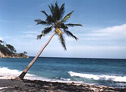
 Beach in Cayo Levantado
 -
 Coast of Cayo Levantado


_Dominican_Republic_(24)_(16787123461).jpg)

References[change | change source]
- ↑ Columbus, Christopher; de las Casas, Bartolomé, Dunn, O.C., and Kelley, James E. (1989). The Diario of Christopher Columbus's First Voyage to America, 1492-1493. Norman: University of Oklahoma Press. ISBN 9780806121017.
{{cite book}}: CS1 maint: multiple names: authors list (link)