
Villefranche-de-Rouergue
Villefranche-de-Rouergue | |
|---|---|
Subprefecture and commune | |
 Villefranche from St-Jean d'Aigremont | |
.svg) Coat of arms | |
Location of Villefranche-de-Rouergue  | |
 Villefranche-de-Rouergue  Villefranche-de-Rouergue | |
| Coordinates: 44°21′12″N 2°02′06″E / 44.3533°N 2.035°E | |
| Country | France |
| Region | Occitanie |
| Department | Aveyron |
| Arrondissement | Villefranche-de-Rouergue |
| Canton | Villefranche-de-Rouergue |
| Intercommunality | Le Grand Villefranchois |
| Government | |
| • Mayor (2014-2020) | Serge Roques[1] |
| Area 1 | 45.85 km2 (17.70 sq mi) |
| Population (2014) | 11,822 |
| • Density | 260/km2 (670/sq mi) |
| Demonym | Villefranchois |
| Time zone | UTC+01:00 (CET) |
| • Summer (DST) | UTC+02:00 (CEST) |
| INSEE/Postal code | 12300 /12200 |
| Elevation | 237–544 m (778–1,785 ft) (avg. 391 m or 1,283 ft) |
| Website | www.villefranchederouergue.fr |
| 1 French Land Register data, which excludes lakes, ponds, glaciers > 1 km2 (0.386 sq mi or 247 acres) and river estuaries. | |
Villefranche-de-Rouergue (Occitan: Vilafranca de Roergue) is a commune in southern France in the Aveyron department, in the region of Occitanie. It is the sous-prefecture (capital) of the arrondissement of the same name in the Aveyron department.
History[change | change source]
In 1252, Alphonse de Poitiers, Count of Toulouse, sent Jean d'Arcis, Seneschal of Rouergue, to build a city along the Aveyron as a new capital for Rouergue (an old French province): Villefranche-de-Rouergue. From 1369 to the French Revolution, Villefranche-de-Rouergue was the capital of Rouergue.[2]
Geography[change | change source]
Villefranche-de-Rouergue is in the valley of the Aveyron river along the line that separates the Causses (limestone plateaus) from the Ségala geographical region.
There are mines of copper, lead, tin, iron and silver.
The Alzou river joins in the city, as a right tributary, the Aveyron river.
Villefranche-de-Rouergue has an area of 45.9 km2 (17.7 sq mi),[3] and its average altitude in the city is 391 m (1,283 ft); at the city hall, the altitude is 323 m (1,060 ft).[4]

|
Villefranche-de-Rouergue is surrounded by the communes Saint-Rémy, Maleville, La Bastide-l'Évêque, Morlhon-le-Haut, Sanvensa, La Rouquette, Savignac and Toulonjac.
Places next to Villefranche-de-Rouergue | |
|---|---|
Climate[change | change source]
The climate of Villefranche-de-Rouergue, in the Köppen climate classification, is Cfb - Oceanic climate with template summers.
Population[change | change source]
The inhabitants of Villefranche-de-Rouergue are known, in French, as Villefranchois (women: Villefranchoises).[5]
With a population of 11,822,[6] Villefranche-de-Rouergue has a population density of 258 inhabitants/km2.
Evolution of the population in Villefranche-de-Rouergue

Villefranche-de-Rouergue forms with Toulonjac the urban area of Villefranche-de-Rouergue with a population of 12,644 inhabitants (2013) and an area of 53.1 km2 (20.5 sq mi).[7] This urban area is the centre of the metropolitan area of Villefranche-de-Rouergue, formed by 16 communes with a population of 20,180 inhabitants and an area of 357.8 km2 (138.1 sq mi).[8]
Administration[change | change source]
Villefranche-de-Rouergue is a subprefecture of the Aveyron department, the capital of the arrondissement of Villefranche-de-Rouergue and the administrative centre (French: chef-lieu) of the canton of Villefranche-de-Rouergue, with 13,282 inhabitants (2014).
It is part of the intercommunality Le Grand Villefranchois (French: Communauté de communes du Grand Villefranchois).
Sister cities[change | change source]
Villefranche-de-Rouergue is twinned with:
Gallery[change | change source]
-
 City Hall
 -
 Municipal theatre
 -
 Notre-Dame square
 -
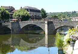 Pont des Consuls or Pont-Vieux


References[change | change source]
- ↑ "Le conseil municipal" (in French). Mairie de Millau. Archived from the original on 28 January 2017. Retrieved 17 March 2017.
- ↑ "Villefranche, ville nouvelle du moyen âge" (in French). Mairie de Villefranche-de-Rouergue. Archived from the original on 10 January 2021. Retrieved 27 June 2014.
- ↑ "Commune de Villefranche-de-Rouergue (12300)". Comparateur de territoire (in French). Institut national de la statistique et des études économiques - INSEE. Retrieved 17 March 2017.
- ↑ "Villefranche-de-Rouergue". Map-France.com. Retrieved 27 June 2014.
- ↑ "Villefranche-de-Rouergue (12200)" (in French). habitants.fr. Retrieved 27 June 2014.
- ↑ "Régions, départements, arrondissements, cantons et communes" (PDF). Populations légales 2014 (in French). Institut national de la statistique et des études économiques - INSEE. Retrieved 17 March 2017.
- ↑ "Unité urbaine de Villefranche-de-Rouergue (12301)". Comparateur de territoire (in French). Institut national de la statistique et des études économiques - INSEE. Retrieved 17 March 2017.
- ↑ "Aire urbaine de Villefranche-de-Rouergue (255)". Comparateur de territoire (in French). Institut national de la statistique et des études économiques - INSEE. Retrieved 17 March 2017.
Related pages[change | change source]
Other websites[change | change source]
- Mairie de Villefranche-de-Rouergue - Official website (in French)
- Office de Tourisme de Villefranche-de-Rouergue (in French)