
Aveyron
Aveyron | |
|---|---|
 | |
 Flag  Coat of arms | |
 Location of Aveyron in France | |
| Coordinates: 44°15′N 02°42′E / 44.250°N 2.700°E | |
| Country | France |
| Region | Occitanie |
| Département | 4 March 1790 |
| Prefecture | Rodez |
| Subprefectures | Millau, Villefranche-de-Rouergue |
| Government | |
| • President | Jean-Claude Luche |
| Area | |
| • Total | 8,735.1 km2 (3,372.6 sq mi) |
| Population (2014)[3] | |
| • Total | 278,644 |
| • Rank | 78th |
| • Density | 32/km2 (83/sq mi) |
| Demonym | Aveyronnais |
| Time zone | UTC+1 (CET) |
| • Summer (DST) | UTC+2 (CEST) |
| ISO 3166 code | FR-12 |
| Arrondissements | 3 |
| Cantons | 23 |
| Communes | 286 |
| Website | http://aveyron.fr/ |
Aveyron (Occitan: Avairon) is a French department found in the northeast of the Occitanie region of southern France and named after the Aveyron river. Its prefecture is Rodez.
History[change | change source]
Aveyron is one of the 83 French departments made during the French revolution, on 4 March 1790. It was created with most of the territory of the old province of Rouergue; in fact, the present flag of the department was the flag of Rouergue.
The first known historical inhabitants of the region were the Rutenii tribe but, before them, the area was inhabited by people that built many prehistoric ruins including over 1,000 dolmens - more than any other department in France.
In 1808, the old canton of Saint-Antonin-Noble-Val was transferred from Aveyron to the new department of Tarn-et-Garonne.[4][5]
Geography[change | change source]

Aveyron is part of the Occitanie region, in southern France, and is the 6th French department in area with 8,735.1 km2 (3,373 sq mi).[2]
The department borders with 7 other departments:[5]
Aveyron is in the southern half of the central plateau (Massif Central) of France. The mountainous areas (the Aubrac mountains, Palanges Levezou and Lacaune) cover little more than a third of the territory, with the highest point in Signal de Mailhe-Biau (the northwest peak, 42°40′17″N 03°04′19″E / 42.67139°N 3.07194°E) that is 1,463 m (4,800 ft) high[6] and is in the region called Cazalets; the remaining two thirds are occupied by hills and plateaus (Ségala, Viadène, Lagast and Grands Causses), with a few valleys.
The territory is crossed, among others, by the rivers Lot and Tarn, both tributaries of the Garonne river. The Aveyron river, which gives its name to the department, is a tributary of the Tarn river.
The main rivers of Aveyron are the Lot in the north, the Aveyron in the centre and the Tarn in the south, all tributaries of the Garonne. They flow from east to west, following the general slope of the department, and divide it into four zones.
Climate[change | change source]
The climate of the Aveyron is subtropical with dry-summer, Csb (Mediterranean Climate) in the Köppen climate classification.
The average temperature for the year in Millau is 10.9 °C (51.6 °F). The warmest month, on average, is July with an average temperature of 19.9 °C (67.8 °F). The coolest month on average is January, with an average temperature of 3.2 °C (37.8 °F).
The average amount of precipitation for the year in Millau is 731.5 mm (28.8 in). The month with the most precipitation on average is September with 78.7 mm (3.1 in) of precipitation. The month with the least precipitation on average is July with an average of 40.6 mm (1.6 in).[7]
Administration[change | change source]
Aveyron is part of the region of Occitanie. The department is managed by the Departamental Council of the Aveyron in Rodez.
Administrative divisions[change | change source]
There are 3 arrondissements (districts), 23 cantons and 286 communes (municipalities) in Aveyron.
| INSEE code |
Arrondissement | Capital | Population[8] (2014) |
Area[9] (km²) |
Density (Inh./km²) |
Communes |
|---|---|---|---|---|---|---|
| 121 | Millau | Millau | 70,995 | 3,467.3 | 20.5 | 97 |
| 122 | Rodez | Rodez | 143,841 | 3,974.4 | 36.2 | 127 |
| 123 | Villefranche-de-Rouergue | Villefranche-de-Rouergue | 63,808 | 1,293.4 | 49.3 | 62 |
-

-
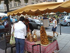 Rodez market
 -
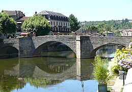 Pont des Consuls, Villefranche-de-Rouergue


The following is a list of the 23 cantons of the Aveyron department (with their INSEE codes), in France, following the French canton reorganisation which came into effect in March 2015:[10]
- Aubrac et Carladez (1201)
- Aveyron et Tarn (1202)
- Causse-Comtal (1203)
- Causses-Rougiers (1204)
- Ceor-Ségala (1205)
- Enne et Alzou (1206)
- Lot et Dourdou (1207)
- Lot et Montbazinois (1208)
- Lot et Palanges (1209)
- Lot et Truyère (1210)
- Millau-1 (1211)
- Millau-2 (1212)
- Monts du Réquistanais (1213)
- Nord-Lévezou (1214)
- Raspes et Lévezou (1215)
- Rodez-1 (1216)
- Rodez-2 (1217)
- Rodez-Onet (1218)
- Saint-Affrique (1219)
- Tarn et Causses (1220)
- Vallon (1221)
- Villefranche-de-Rouergue (1222)
- Villeneuvois et Villefranchois (1223)
Demographics[change | change source]
The inhabitants of Aveyron are known, in French, as Aveyronnais (women: Aveyronnaises).[11]
Aveyron has a population, in 2014, of 278,644,[3] for a population density of 31.9 inhabitants/km2. The arrondissement of Rodez, with 143,841 inhabitants, is by far the largest. The other two, Millau and Villefranche-de-Rouergue, have respectively 70,995 and 63,808 inhabitants.[8]
The city with more people living in it is the capital, Rodez (24,088). The subprefectures of Millau and Villefranche-de-Rouergue have, respectively, 22,064 and 11,822 inhabitants.[8]
Evolution of the population in Aude

The 10 most important cities in the department are:

| City | Population[8] (2014) |
Arrondissement |
|---|---|---|
| Rodez | 24,088 | Rodez |
| Millau | 22,064 | Millau |
| Onet-le-Château | 11,837 | Rodez |
| Villefranche-de-Rouergue | 11,822 | Villefranche-de-Rouergue |
| Saint-Affrique | 8,260 | Millau |
| Luc-la-Primaube | 5,898 | Rodez |
| Decazeville | 5,686 | Villefranche-de-Rouergue |
| Capdenac-Gare | 4,558 | Villefranche-de-Rouergue |
| Espalion | 4,460 | Rodez |
| Sévérac d'Aveyron | 4,134 | Millau |
Related pages[change | change source]
References[change | change source]
- ↑ "Le Président du Conseil départemental". Conseil départemental de l'Aveyron (in French). Archived from the original on 26 January 2017. Retrieved 9 January 2017.
- ↑ 2.0 2.1 "Comparateur de territoire Département de l'Aveyron (12)". Publications et statistiques pour la France ou les régions (in French). Institut national de la statistique et des études économiques - INSEE. Retrieved 9 January 2017.
- ↑ 3.0 3.1 "Populations légales 2014 des départements et des collectivités d'outre-mer" (in French). Institut national de la statistique et des études économiques - INSEE. Retrieved 9 January 2017.
- ↑ Création du département de Tarn-et-Garonne
- ↑ 5.0 5.1 "Historique de l'Aveyron". Le SPLAF (in French). Retrieved 15 April 2014.
- ↑ "Signal de Mailhe-Biau--Northwest Peak, France". Peakbagger.com. Retrieved 8 September 2016.
- ↑ "Millau, France - Köppen Climate Classification". Weatherbase. Retrieved 17 April 2014.
- ↑ 8.0 8.1 8.2 8.3 "Régions, départements, arrondissements, cantons et communes" (PDF). Populations légales 2014 (in French). Institut national de la statistique et des études économiques - INSEE. Retrieved 7 January 2017.
- ↑ "Département de l'Aveyron (12) et Arrondissements". Comparateur de territoire (in French). Institut national de la statistique et des études économiques - INSEE. Retrieved 9 January 2017.
- ↑ Décret n° 2014-205 du 21 février 2014 portant délimitation des cantons dans le département de l'Aveyron
- ↑ "Aveyron (12)" (in French). habitants.fr. Retrieved 17 April 2014.
Other websites[change | change source]
- Departamental Council website (in French)
- Prefecture website Archived 2007-03-20 at the Wayback Machine (in French)
- aveyron.com website Archived 2015-10-07 at the Wayback Machine
- Aveyron tourism official website Archived 2014-05-01 at the Wayback Machine