
Ain
Ain | |
|---|---|
 Prefecture building of the Ain department, in Bourg-en-Bresse | |
 Flag  Coat of arms | |
 Location of Ain in France | |
| Coordinates: 46°5′N 5°20′E / 46.083°N 5.333°E | |
| Country | France |
| Region | Auvergne-Rhône-Alpes |
| Département | 4 March 1790 |
| Prefecture | Bourg-en-Bresse |
| Subprefectures | Belley, Gex, Nantua |
| Government | |
| • President | Jean Deguerry |
| Area | |
| • Total | 5,762.4 km2 (2,224.9 sq mi) |
| Population (2014)[3] | |
| • Total | 626,127 |
| • Density | 110/km2 (280/sq mi) |
| Time zone | UTC+1 (CET) |
| • Summer (DST) | UTC+2 (CEST) |
| ISO 3166 code | FR-01 |
| Arrondissements | 4 |
| Cantons | 23 |
| Communes | 410 |
| Website | www.ain.fr/ |
Ain is a department in the east of France, in the Auvergne-Rhône-Alpes region. It is named after the river Ain. Its prefecture is Bourg-en-Bresse.
History
[change | change source]Ain is one of the original 83 departments created during the French Revolution on 4 March 1790 with Bourg-en-Bresse as is capital.[4] It was formed with four former provinces: Bresse, Bugey, Dombes, Pays de Gex and part of the province of Franc-Lyonnais.
It was divided in nine districts: Pont-de-Vaux, Bourg, Nantua, Gex, Belley, Saint-Rambert, Montluel, Trévoux and Châtillon-les-Dombes.
The department was called départment of Bresse but in 1791 was changed to its present name: départment de l'Ain.[5]
In 1798, Gex was separated from Ain for the creation of the old department of Léman.
In 1800, with the creation of the arrondissements in France, the nine districts were changed into four arrondissements: Bourg, Belley, Nantua and Trévoux.[4]
The department of Léman was eliminated in 1814 and Gex was again part of the department of Ain. In 1815, some communes of Gex are passed to Switzerland and the arrondissement of Gex is created.
On 10 September 1926, the arrondissements of Gex and Trévoux were eliminated but in 1933 Gex was made again an arrondissement.[4]
Geography
[change | change source]
Ain is part of the Auvergne-Rhône-Alpes region. It has an area of 5,762.4 km2 (2,225 sq mi).[2]
The department borders with Switzerland and 6 other departments in 2 regions:
- Auvergne-Rhône-Alpes region
- Haute-Savoie (east)
- Savoie (southeast)
- Isère (south)
- Rhône (southwest)
- Bourgogne-Franche-Comté region
- Jura (north)
- Saône-et-Loire (northwest)
Places next to Ain | |
|---|---|
The territory of the Ain department is formed by five regions:[6]
- Bresse, a plain between the Saône river to the east and the Jura mountains to the west.
- Bugey-Valromey, surrounded by the Rhône and the Ain rivers, in the southern end of the Jura mountains.
- Dombes-Plain of the Ain, in the southeast of the department, surrounded by the Rhône and the Saône rivers. Here there are many ponds and small lakes where fishes are commercially grown.
- Pays de Gex. It has the Swiss border to the east, the mountains of Bugey to the west and the Jura mountains to the north. Here is the highest point of the Jura mountains and of the Ain department: Crêt de la Neige (46°16′22″N 05°56′40″E / 46.27278°N 5.94444°E), 1,720 m (5,643 ft) high.[7]
- Revermont. Here there are two ranges of low mountains that go from north to south with a valley between them: the valley of the Suran river. This region is between the Bresse and Bugey-Valromey regions.
The lowest point of the department is on the Rhône river, 170 m (560 ft) high.
Several rivers flow through the department; the main rivers are the Rhône, the Ain and the Saône. The largest natural lake is the Nantua lake, with an area of 1.41 km2 (0.54 sq mi).
Climate
[change | change source]The Köppen climate classification type for the climate at Château-Gaillard (Ain) is an "Oceanic climate" (also known as Marine West Coast Climate) and of the subtype Cfb.[8]
The average amount of precipitation for the year in Château-Gaillard is 645.2 mm (25.4 in). The month with the most precipitation on average is October with 63.5 mm (2.5 in) of precipitation. The month with the least precipitation on average is February with an average of 43.2 mm (1.7 in).
The average temperature for the year in Château-Gaillard is 11.5 °C (52.7 °F). The warmest month, on average, is July with an average temperature of 20.8 °C (69.4 °F). The coolest month on average is January, with an average temperature of 2.6 °C (36.7 °F).
| Climate data for Château-Gaillard, France | |||||||||||||
|---|---|---|---|---|---|---|---|---|---|---|---|---|---|
| Month | Jan | Feb | Mar | Apr | May | Jun | Jul | Aug | Sep | Oct | Nov | Dec | Year |
| Average high °C (°F) | 5.9 (42.6) |
7.9 (46.2) |
12.7 (54.9) |
16.1 (61.0) |
20.4 (68.7) |
24.1 (75.4) |
27 (81) |
26.6 (79.9) |
22 (72) |
16.9 (62.4) |
10.3 (50.5) |
6.5 (43.7) |
16.4 (61.5) |
| Daily mean °C (°F) | 2.6 (36.7) |
3.8 (38.8) |
7.5 (45.5) |
10.6 (51.1) |
14.9 (58.8) |
18.2 (64.8) |
20.8 (69.4) |
20.3 (68.5) |
16.5 (61.7) |
12.5 (54.5) |
6.7 (44.1) |
3.5 (38.3) |
11.5 (52.7) |
| Average low °C (°F) | −0.8 (30.6) |
−0.3 (31.5) |
2.3 (36.1) |
5 (41) |
9.4 (48.9) |
12.3 (54.1) |
14.6 (58.3) |
14 (57) |
10.9 (51.6) |
8.1 (46.6) |
3 (37) |
0.4 (32.7) |
6.6 (43.8) |
| Average rainfall mm (inches) | 50.5 (1.99) |
42.1 (1.66) |
47.7 (1.88) |
50.9 (2.00) |
61.7 (2.43) |
56.6 (2.23) |
54.4 (2.14) |
52.2 (2.06) |
53.3 (2.10) |
63.6 (2.50) |
51.2 (2.02) |
60.6 (2.39) |
644.8 (25.4) |
| Source: Weatherbase.com [1] | |||||||||||||
Administration
[change | change source]Ain is managed by the Departmental Council of Ain in Bourg-en-Bresse. The department is part of the Auvergne-Rhône-Alpes region.
Administrative divisions
[change | change source]There are 4 arrondissements (districts), 23 cantons and 410 communes (municipalities) in Ain.[9]
| INSEE code |
Arrondissement | Capital | Population[10] (2014) |
Area[11] (km²) |
Density (Inh./km²) |
Communes |
|---|---|---|---|---|---|---|
| 011 | Belley | Belley | 98,110 | 1,394.5 | 70.4 | 115 |
| 012 | Bourg-en-Bresse | Bourg-en-Bresse | 354,177 | 3,104.8 | 114.1 | 201 |
| 013 | Gex | Gex | 89,200 | 426.2 | 209.3 | 27 |
| 014 | Nantua | Nantua | 84,640 | 837.0 | 101.1 | 65 |
The following is a list of the 23 cantons of the Ain department (with their INSEE codes), following the French canton reorganisation which came into effect in March 2015:[12]
- Ambérieu-en-Bugey (0101)
- Attignat (0102)
- Bellegarde-sur-Valserine (0103)
- Belley (0104)
- Bourg-en-Bresse-1 (0105)
- Bourg-en-Bresse-2 (0106)
- Ceyzériat (0107)
- Châtillon-sur-Chalaronne (0108)
- Gex (0109)
- Hauteville-Lompnes (0110)
- Lagnieu (0111)
- Meximieux (0112)
- Miribel (0113)
- Nantua (0114)
- Oyonnax (0115)
- Pont-d'Ain (0116)
- Replonges (0117)
- Saint-Étienne-du-Bois (0118)
- Saint-Genis-Pouilly (0119)
- Thoiry (0120)
- Trévoux (0121)
- Villars-les-Dombes (0122)
- Vonnas (0123)
Demographics
[change | change source]There is not an official demonym for the inhabitants of the Ain department; people are named after the regions:
- Bresse - Bressans
- Bugey - Bugistes
- Revermont - Revermontois
- Dombes - Dombistes
- Pays de Gex - Gessiens
Ain had a population, in 2014, of 626,127,[3] for a population density of 108.7 inhabitants/km2. The arrondissement of Bourg-en-Bresse, with 354,177 inhabitants, is the arrondissement with more inhabitants.[10]

The communes in the department with more than 8,000 inhabitants are:[10]
| City | Population[10] (2014) |
Arrondissement |
|---|---|---|
| Bourg-en-Bresse | 40,967 | Bourg-en-Bresse |
| Oyonnax | 22,485 | Nantua |
| Ambérieu-en-Bugey | 14,022 | Belley |
| Bellegarde-sur-Valserine | 11,745 | Nantua |
| Gex | 11,141 | Gex |
| Saint-Genis-Pouilly | 9,854 | Gex |
| Miribel | 9,425 | Bourg-en-Bresse |
| Ferney-Voltaire | 9,337 | Gex |
| Divonne-les-Bains | 9,100 | Gex |
| Belley | 8,983 | Belley |
Gallery
[change | change source]-
 Bleu de Gex cheese
 -
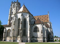 Church of Brou (Bourg-en-Bresse)
 -
 Prefecture (view from the parc)
 -

-
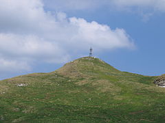 The summit of Le Reculet peak


.JPG)

Related pages
[change | change source]References
[change | change source]- ↑ "Ain : Jean Deguerry remplace Damien Abad à la présidence du Département", France 3, 10.07.2017.
- ↑ 2.0 2.1 "Département de L'Ain (01) - Résumé statistique". Publications et statistiques pour la France ou les régions (in French). Institut national de la statistique et des études économiques - INSEE. Retrieved 8 November 2016.
- ↑ 3.0 3.1 "Populations légales 2014 des départements et des collectivités d'outre-mer" (in French). Institut national de la statistique et des études économiques - INSEE. Retrieved 16 September 2017.
- ↑ 4.0 4.1 4.2 "Historique de l'Ain". Le SPLAF (in French). Retrieved 8 November 2016.
- ↑ "Carte du départment de l'Ain". Patrimoine[s] de l'Ain (in French). Retrieved 8 November 2016.
- ↑ "Géographie". Ain.fr. Conseil Général de l'Ain. Archived from the original on 16 January 2017. Retrieved 8 November 2016.
- ↑ "Crêt de la Neige, France". Peakbagger.com. Retrieved 8 November 2016.
- ↑ "Château-Gaillard, France - Köppen Climate Classification". Weatherbase. Retrieved 8 November 2016.
- ↑ "Département de l'Ain (01)" (in French). Institut national de la statistique et des études économiques - INSEE. Retrieved 16 September 2017.
- ↑ 10.0 10.1 10.2 10.3 "Régions, départements, arrondissements, cantons et communes" (PDF). Populations légales 2014 (in French). Institut national de la statistique et des études économiques - INSEE. Retrieved 16 September 2017.
- ↑ "Département de l'Ain (01) et Arrondissements". Comparateur de territoire (in French). Institut national de la statistique et des études économiques - INSEE. Retrieved 16 September 2017.
- ↑ "Décret n° 2014-147 du 13 février 2014 portant délimitation des cantons dans le département de l'Ain" (in French). Légifrance.gouv.fr. Retrieved 8 November 2016.
Other websites
[change | change source]- Prefecture website (in French)
- General Council website (in French)
- Tourism site