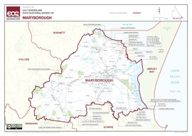
Electoral district of Maryborough (Queensland)
| Maryborough Queensland—Legislative Assembly | |||||||||||||||
|---|---|---|---|---|---|---|---|---|---|---|---|---|---|---|---|
 Electoral map of Maryborough 2017 | |||||||||||||||
| State | Queensland | ||||||||||||||
| Created | 1865 | ||||||||||||||
| MP | Bruce Saunders | ||||||||||||||
| Party | Labor | ||||||||||||||
| Namesake | Maryborough | ||||||||||||||
| Electors | 38,267 (2020) | ||||||||||||||
| Area | 4,705 km2 (1,816.6 sq mi) | ||||||||||||||
| Demographic | Provincial | ||||||||||||||
| Coordinates | 25°39′S 152°30′E / 25.650°S 152.500°E | ||||||||||||||
| |||||||||||||||
Maryborough is an electoral district of Queensland. It was created in 1865.
Election results[change | change source]
| 2020 Queensland state election: Maryborough[1] | |||||
|---|---|---|---|---|---|
| Party | Candidate | Votes | % | ±% | |
| Labor | Bruce Saunders | 17,751 | 53.27 | +8.08 | |
| Liberal National | Denis Chapman | 8,763 | 26.30 | +8.26 | |
| One Nation | Sharon Lohse | 4,392 | 13.18 | −17.18 | |
| Greens | Craig Armstrong | 888 | 2.66 | −0.84 | |
| Legalise Cannabis | River Body | 885 | 2.66 | +2.66 | |
| Informed Medical Options | Samantha Packer | 452 | 1.36 | +1.36 | |
| United Australia | Alex Sokolov | 194 | 0.58 | +0.58 | |
| Total formal votes | 33,325 | 96.26 | +0.05 | ||
| Informal votes | 1,293 | 3.74 | −0.05 | ||
| Turnout | 34,618 | 90.46 | +0.00 | ||
| Two-party-preferred result | |||||
| Labor | Bruce Saunders | 20,624 | 61.89 | +9.43 | |
| Liberal National | Denis Chapman | 12,701 | 38.11 | +38.11 | |
| Labor hold | Swing | +9.43 | |||
