Jefferson Parish, Louisiana
Jefferson Parish | |
|---|---|
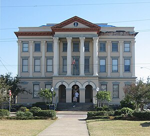
 City Hall in Gretna | |
 Location within the U.S. state of Louisiana | |
 Louisiana's location within the U.S. | |
| Coordinates: 29°44′N 90°06′W / 29.73°N 90.1°W | |
| Country | |
| State | |
| Founded | February 11, 1825 |
| Named for | Thomas Jefferson |
| Seat | Gretna |
| Largest community | Metairie |
| Area | |
| • Total | 665 sq mi (1,720 km2) |
| • Land | 296 sq mi (770 km2) |
| • Water | 370 sq mi (1,000 km2) 56% |
| Population (2020) | |
| • Total | 440,781 |
| • Density | 1,489/sq mi (575/km2) |
| Time zone | UTC−6 (Central) |
| • Summer (DST) | UTC−5 (CDT) |
| Area code | 504,985 |
| Congressional districts | 1st, 2nd, 6th |
| Website | www |
Jefferson Parish is a parish in the U.S. state of Louisiana. Most of the suburbs of New Orleans are in this parish. Because of this Jefferson parish has the second-most population in the state.
Other websites[change | change source]
- Official website
- Jefferson Parish Sheriff's Office
- Jefferson Parish Convention and Visitors Bureau - Tourism Archived 2008-05-13 at the Wayback Machine
- Jefferson Parish Clerk of Court's Office
- Jefferson Historical Society of Louisiana
- East Jefferson Online Community Archived 2006-04-27 at the Wayback Machine - current events, history and organizational information.
Wikimedia Commons has media related to Jefferson Parish, Louisiana.


