
Natchitoches Parish, Louisiana
Natchitoches Parish | |
|---|---|
 Natchitoches Parish Courthouse (completed 1939 as a WPA project) | |
 Location within the U.S. state of Louisiana | |
 Louisiana's location within the U.S. | |
| Coordinates: 31°44′N 93°06′W / 31.73°N 93.1°W | |
| Country | |
| State | |
| Founded | April 10, 1805 |
| Named for | Natchitoches people |
| Seat | Natchitoches |
| Largest city | Natchitoches |
| Area | |
| • Total | 1,300 sq mi (3,366 km2) |
| • Land | 1,253 sq mi (3,246 km2) |
| • Water | 46 sq mi (120 km2) 3.6% |
| Population (2020) | |
| • Total | 37,515 |
| • Density | 29.9/sq mi (11.5/km2) |
| Time zone | UTC−6 (Central) |
| • Summer (DST) | UTC−5 (CDT) |
| Area code | 318 |
| Congressional district | 4th |
| Website | www |
Natchitoches Parish (French: Paroisse des Natchitoches ou Les Natchitoches) is a parish located in the U.S. state of Louisiana. As of the 2020 census, the population was 37,515.[1] The parish seat and most populous municipality is Natchitoches.[2] The parish was formed in 1805.[3] It was named after the Natchitoches Native Americans.[4]
Image[change | change source]
-
 The Natchitoches Parish Library.
 -
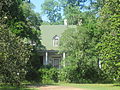 Hidden by trees, the Magnolia Plantation is located in the Cane River Creole National Historical Park.
 -


References[change | change source]
- ↑ "QuickFacts: Natchitoches Parish, Louisiana". United States Census Bureau. Retrieved October 5, 2023.
- ↑ "Find a County". National Association of Counties. Retrieved 2011-06-07.
- ↑ "Natchitoches Parish". Center for Regional Heritage Research. Retrieved September 6, 2014.
- ↑ "Natchitoches | Louisiana, United States". Encyclopedia Britannica. Retrieved 2021-08-22.
Municipalities and communities of Natchitoches Parish, Louisiana, United States | ||
|---|---|---|
| City |  | |
| Town | ||
| Villages | ||
| CDPs | ||
| Other communities |
| |
| Ghost towns | ||
| Footnotes | ‡This populated place also has portions in an adjacent county or counties | |

| International | |
|---|---|
| National | |
| Other | |