The Guianas

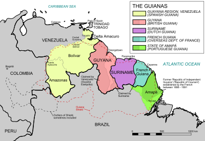
The Guianas (French: Guyanes; Dutch: Guyana's; Spanish: Guayanas) are a region in northeastern South America along the Atlantic coast, divided in several territories and independent countries.
Geography[change | change source]
The Guianas are on the Guiana Shield, a Precambrian geological formation that is limited to the south and to the east by Brazil, to the west by Venezuela and to the north by the Atlantic Ocean.
The Guianas includes the following three territories, from west to east:
- Guyana, an independent country;
- Suriname, also an independent country; and
- French Guiana, an overseas department of France.
Two other territories are sometimes added:
- The Guayana Region, formerly the Guayana Province, in southeast Venezuela (Spanish Guyana)
- Portuguese Guiana (Brazilian Guiana), in northeastern Brazil, originally part of the Portuguese Empire, now corresponding to the Brazilian State of Amapá.
History[change | change source]
The territories of the Guianas were made colonies from the 17th century by England, Netherlands, France, Portugal and Spain, resulting in its present division. The colonies were then:
- British Guiana, independent since 1966 with the name of Guyana;
- Spanish Guiana, the present southeastern Venezuela;
- French Guiana or Guyane, an overseas region and department of France;
- Dutch Guiana, independent since 1975 with the name of Suriname;
- Portuguese Guiana, later the Brazilian Guiana and now the Brazilian state of Amapá.
Countries[change | change source]
Guyana[change | change source]
Guyana (officially the Co-operative Republic of Guyana) is bordered by the Atlantic Ocean to the north, Brazil to the south and southwest, Suriname to the east and Venezuela to the west. It has an area of 214,969 km2 (83,000 sq mi) with a population of 735,909 (estimate for July 2016).[1] The population density is of 3.4 inhabitants/km2. The official language is English.
The largest cities (2012 census) are: Georgetown (118,363 inhabitants), Linden (27,277 inhabitants) and New Amsterdam (17,329 inhabitants).[2]
The highest point is Mount Roraima (5°13′N 60°44′W / 5.217°N 60.733°W) at 2,772 m (9,094 ft) high.[3] It is in the Pacaraima Mountains, a mountain range in the southwest of the country.
The largest river of the country is the Essequibo river; it starts in the Acarai Mountains and flows to the north for 1,010 kilometres (630 mi) into the Atlantic Ocean at 21 kilometres (13 mi) from Georgetown, the capital city of Guyana.
Suriname[change | change source]
Suriname (officially the Republic of Suriname, Dutch: Republiek Suriname) is bordered by the Atlantic Ocean to the north, French Guiana to the east, Guyana to the west and Brazil to the south. It has an area of 163,820 km2 (63,250 sq mi) with a population of 585,824 (estimate for July 2016).[4] The population density is of 3.6 inhabitants/km2. The official language is Dutch.
The largest cities (2012 census) are: Paramaribo (240,924 inhabitants), Koewarasan (27,713 inhabitants) and De Nieuwe Grond (26,161 inhabitants).[5]
The highest point is Julianatop (3°40′58″N 56°32′8″W / 3.68278°N 56.53556°W) at 1,230 m (4,040 ft) high.[6] It is in the Sipaliwini District in the center of the country.
The largest river of the country is the Courantyne river; it starts in the Acarai Mountains and flows to the north for about 724 kilometres (450 mi) into the Atlantic Ocean between Guyana and Suriname.
French Guiana[change | change source]
French Guiana (French: Guyane) is an overseas department and region of France. It is bordered by Surinam to the west, Brazil to the south and east, and the Atlantic Ocean to the north. It has an area of 83,533.9 km2 (32,252.6 sq mi),[7] with a population of 252,338.[8] The population density is of 1.5 inhabitants/km2. The official language is French.
The largest cities (2014) are: Cayenne (55,817 inhabitants), Saint-Laurent-du-Maroni (44,169 inhabitants) and Matoury (31,934 inhabitants).[9]
The highest point is Bellevue de l'Inini (3°35′N 53°31′W / 3.583°N 53.517°W) at 851 m (2,792 ft) high.[10]
The main rivers of the French Guiana are:
- The Maroni (Dutch: Marowijne) river that forms the border between French Guiana and Suriname; it starts in the Tumuk Humak Mountains and is 611.7 kilometres (380.1 mi) long.
- The Mana river, 430 kilometres (270 mi) long.
- The Oyapock river (Portuguese: Oiapoque; Dutch: Oiapoque) that forms the border betweeen French Guiana and Brazil; it is 403.4 kilometres (250.7 mi) long.
References[change | change source]
- ↑ "The World Factbook: Guyana". CIA. Archived from the original on 30 May 2015. Retrieved 16 February 2017.
- ↑ "Guyana Population and Housing Census 2012: Preliminary Report". Bureau of Statistics, Guyana. June 2014. Retrieved 16 February 2017.
- ↑ "Mount Roraima-Guyana High Point, Guyana/Venezuela". Peakbagger.com. Retrieved 16 February 2017.
- ↑ "The World Factbook: Suriname". CIA. Archived from the original on 30 May 2015. Retrieved 16 February 2017.
- ↑ "Suriname: Districts, Cities & Urban Communes". City Population. Retrieved 16 February 2017.
- ↑ "Julianatop, Suriname". Peakbagger.com. Retrieved 16 February 2017.
- ↑ "Département de la Guyane (973)". Comparateur de territoire (in French). Institut national de la statistique et des études économiques - INSEE. Retrieved 16 February 2017.
- ↑ "Populations légales 2014: Recensement de la population - Population des régions" (in French). Institut national de la statistique et des études économiques - INSEE. Retrieved 16 February 2017.
- ↑ "Régions, départements, arrondissements, cantons et communes" (PDF). Populations légales 2014 (in French). Institut national de la statistique et des études économiques - INSEE. Retrieved 12 February 2017.
- ↑ "Bellevue de L'Inini, French Guiana". Peakbagger.com. Retrieved 16 February 2017.
