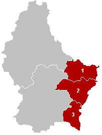
Grevenmacher District
Grevenmacher District | |
|---|---|
 Location of the Grevenmacher district | |
| Coordinates: 49°40′N 6°25′E / 49.667°N 6.417°E | |
| Country | Luxembourg |
| Established | 24 February 1843 |
| Capital | Grevenmacher |
| Subdivisions | |
| Area | |
| • Total | 524.8 km2 (202.6 sq mi) |
| Population (2014)[1] | |
| • Total | 64,978 |
| • Density | 120/km2 (320/sq mi) |
| Time zone | UTC+1 (CET) |
| • Summer (DST) | UTC+2 (CEST) |
| ISO 3166 code | LU-G |
The District of Grevenmacher (Luxembourgish: Gréiwemaacher) was one of three districts of the Grand Duchy of Luxembourg. Its capital was the city of Grevenmacher.
In 2015, the districts were abolished.[2]
It was the easternmost of the districts and the smallest of the three districts, with an area of 524.8 km2 (202.6 sq mi). It is the district with less people living in it with a population of 64,978 inhabitants and a population density of 56.2 inhabitants/km².[1]
History[change | change source]
When the districts were created on 24 February 1843, Grevenmacher was one of the three of the country.[3]
On 2012, the communes of Burmerange and Wellenstein were made part of the commune of Schengen. So the number of communes changed from 26 to 24.[4]
Geography[change | change source]
The district of Grevenmacher is bordered to the north by the German state of Rhineland-Palatinate, to the east by the German states of Rhineland-Palatinate and Saarland, to the south by France (the Moselle département) and to the west by the Luxembourg district.
Composition[change | change source]
The Diekirch district has 3 cantons and 24 communes.

| Canton | Capital | Area[5] (km²) |
Population[1] (2014) |
Density (inhab./km²) |
Communes | |
|---|---|---|---|---|---|---|
| 1 | Echternach | Echternach | 185.5 | 17,477 | 94.2 | 8 |
| 2 | Grevenmacher | Grevenmacher | 211.4 | 27,295 | 129.1 | 8 |
| 3 | Remich | Remich | 127.9 | 20,206 | 158.0 | 8 |
Cantons and their communes[change | change source]


References[change | change source]
- ↑ 1.0 1.1 1.2 "Population by canton and municipality 1821 - 2014". Statistics Portal - Grand Duchy of Luxembourg. Retrieved 26 April 2014.
- ↑ "Loi du 2 septembre 2015 portant abolition des districts" (PDF) (in French). Service central de législation. Retrieved 20 May 2016.[permanent dead link]
- ↑ "Mémorial A, 1843, No. 17" (PDF). Service central de législation. p. 45. Archived from the original (PDF) on 5 March 2016. Retrieved 26 April 2014. (in French and German)
- ↑ (in French) "Mémorial A, 2011, No. 110" (PDF). Service central de législation. Archived from the original (PDF) on 19 October 2013. Retrieved 26 April 2014.
- ↑ "Surface area of the cantons and municipalities". Statistics Portal - Grand Duchy of Luxembourg. Retrieved 26 April 2014.
