Washington County, Idaho
Washington County | |
|---|---|
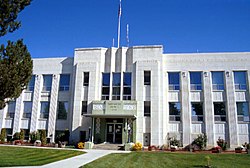
 Washington County Courthouse in Weiser | |
 Location within the U.S. state of Idaho | |
 Idaho's location within the U.S. | |
| Coordinates: 44°27′N 116°47′W / 44.45°N 116.78°W | |
| Country | |
| State | |
| Founded | February 20, 1879 |
| Named for | George Washington |
| Seat | Weiser |
| Largest city | Weiser |
| Area | |
| • Total | 1,474 sq mi (3,820 km2) |
| • Land | 1,453 sq mi (3,760 km2) |
| • Water | 21 sq mi (50 km2) 1.4% |
| Population (2020) | |
| • Total | 10,500 |
| • Density | 7.1/sq mi (2.8/km2) |
| Time zone | UTC−7 (Mountain) |
| • Summer (DST) | UTC−6 (MDT) |
| Congressional district | 1st |
| Website | www |
Washington County is a county in the U.S. state of Idaho. As of the 2020 census, the population was 10,500.[1] The county seat and largest city is Weiser.[2] It has over half of the county's population. The county was founded in 1879 when Idaho was a territory and named after George Washington, the first President of the United States (1789–1797).
Communities[change | change source]
Cities[change | change source]
References[change | change source]
- ↑ "QuickFacts: Washington County, Idaho". United States Census Bureau. Retrieved September 25, 2023.
- ↑ "Find a County". National Association of Counties. Retrieved 2011-06-07.

