
Bullock County, Alabama
Bullock County | |
|---|---|
 Bullock County courthouse in Union Springs | |
 Location within the U.S. state of Alabama | |
 Alabama's location within the U.S. | |
| Coordinates: 32°05′52″N 85°43′02″W / 32.0978°N 85.7172°W | |
| Country | |
| State | |
| Founded | December 5 (created), 1866 |
| Named for | Edward Bullock |
| Seat | Union Springs |
| Largest city | Union Springs |
| Area | |
| • Total | 625 sq mi (1,620 km2) |
| • Land | 623 sq mi (1,610 km2) |
| • Water | 2.3 sq mi (6 km2) 0.4% |
| Population | |
| • Total | 10,357 |
| • Density | 17/sq mi (6.4/km2) |
| Time zone | UTC−6 (Central) |
| • Summer (DST) | UTC−5 (CDT) |
| Website | bullockcountyalrev |
Bullock County, Alabama is a county of the U.S. state of Alabama. Its name is in honor of Colonel Edward C. Bullock of Barbour County. As of 2020 the population was 10,357.[1]
History[change | change source]
Bullock County was formed on December 5, 1866. The boundaries were changed in February 1867. In 1867, Union Springs was chosen as the county seat.
Geography[change | change source]
According to the 2000 census, the county has a total area of 626.06 square miles (1,621.5 km2). 625.01 square miles (1,618.8 km2) (or 99.83%) is land and 1.04 square miles (2.7 km2) (or 0.17%) is water.[2] The county is in the southeastern section of the state, in the prairie region. The Chunnennuggee Ridge runs through the center of the county.
Incorporated cities and towns[change | change source]
Unincorporated communities[change | change source]
- Fitzpatrick
- Inverness
- Perote
- Smut Eye (sometimes Smuteye)
- Thompson
Adjacent counties[change | change source]
- Macon County (north)
- Russell County (northeast)
- Barbour County (southeast)
- Pike County (southwest)
- Montgomery County (west)
Transportation[change | change source]
Major highways[change | change source]
Airport[change | change source]
Franklin Field is a county-owned public-use airport. It is located five nautical miles (9 km) west of the central business district of Union Springs, Alabama.[3]
Places of interest[change | change source]
Bullock County is home to several historic homes including the McCaslan-Garner House and Bonus-Foster-Chapman House.
References[change | change source]
- ↑ 1.0 1.1 "QuickFacts: Bullock County, Alabama". United States Census Bureau. Retrieved August 8, 2023.
- ↑ "Census 2000 U.S. Gazetteer Files: Counties". United States Census. Retrieved 2011-02-13.
- ↑ FAA Airport Master Record for 07A (Form 5010 PDF). Federal Aviation Administration. Effective 3 June 2010.
- Owen, Thomas McAdory. History of Alabama and Dictionary of Alabama Biography. Chicago: S.J. Clarke Publishing Co., 1921.
32°05′52″N 85°43′02″W / 32.09778°N 85.71722°W
Municipalities and communities of Bullock County, Alabama, United States | ||
|---|---|---|
| Cities | 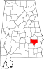 | |
| Towns | ||
| CDP | ||
| Unincorporated communities | ||
| Ghost towns | ||
| International | |
|---|---|
| National | |
| Geographic | |