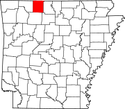
Boone County, Arkansas
Boone County | |
|---|---|
|
Clockwise from top: Boone County Courthouse in Harrison, Buffalo National River, Lake Harrison Park, Overlook from Gaither Mountain in the Ozarks, Harrison Courthouse Square | |
 Location within the U.S. state of Arkansas | |
 Arkansas's location within the U.S. | |
| Coordinates: 36°18′22″N 93°05′38″W / 36.306111111111°N 93.093888888889°W | |
| Country | |
| State | |
| Founded | April 9, 1869 |
| Seat | Harrison |
| Largest city | Harrison |
| Area | |
| • Total | 602 sq mi (1,560 km2) |
| • Land | 590 sq mi (1,500 km2) |
| • Water | 12 sq mi (30 km2) 1.9% |
| Population | |
| • Total | 37,373 |
| • Density | 62/sq mi (24/km2) |
| Time zone | UTC−6 (Central) |
| • Summer (DST) | UTC−5 (CDT) |
| Website | www |
Boone County is a county of the U.S. state of Arkansas. As of the 2020 census, the population was 37,373.[1] The county seat is Harrison.[2] It is Arkansas's 62nd county, founded on April 9, 1869.
References[change | change source]
- ↑ 1.0 1.1 "QuickFacts: Boone County, Arkansas". United States Census Bureau. Retrieved August 8, 2023.
- ↑ "Find a County". National Association of Counties. Archived from the original on 2011-05-31. Retrieved 2011-06-07.


