Phillips County, Arkansas
Phillips County | |
|---|---|
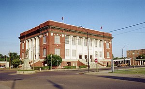
 Phillips County courthouse in Helena-West Helena | |
 Location within the U.S. state of Arkansas | |
 Arkansas's location within the U.S. | |
| Coordinates: 34°23′25″N 90°52′11″W / 34.390277777778°N 90.869722222222°W | |
| Country | |
| State | |
| Founded | May 1, 1820 |
| Named for | Sylvanus Phillips |
| Seat | Helena-West Helena |
| Largest city | Helena-West Helena |
| Area | |
| • Total | 727 sq mi (1,880 km2) |
| • Land | 696 sq mi (1,800 km2) |
| • Water | 32 sq mi (80 km2) 4.4% |
| Population | |
| • Total | 16,568 |
| • Density | 23/sq mi (8.8/km2) |
| Time zone | UTC−6 (Central) |
| • Summer (DST) | UTC−5 (CDT) |
| Website | phillipscounty |
Phillips County is a county of the U.S. state of Arkansas, in what is known as the Arkansas Delta along the Mississippi River. As of the 2020 census, the population was 16,568.[1] The county seat is Helena-West Helena.[2] It was founded on May 1, 1820.
References[change | change source]
- ↑ 1.0 1.1 "QuickFacts: Phillips County, Arkansas". United States Census Bureau. Retrieved August 8, 2023.
- ↑ "Find a County". National Association of Counties. Retrieved 2011-06-07.


