
Union County, Arkansas
Union County | |
|---|---|
 Union County Courthouse in El Dorado | |
 Location within the U.S. state of Arkansas | |
 Arkansas's location within the U.S. | |
| Coordinates: 33°11′14″N 92°35′29″W / 33.187222222222°N 92.591388888889°W | |
| Country | |
| State | |
| Founded | November 2, 1829 |
| Seat | El Dorado |
| Largest city | El Dorado |
| Area | |
| • Total | 1,055 sq mi (2,730 km2) |
| • Land | 1,039 sq mi (2,690 km2) |
| • Water | 16 sq mi (40 km2) 1.5% |
| Population | |
| • Total | 39,054 |
| • Density | 40/sq mi (20/km2) |
| Time zone | UTC−6 (Central) |
| • Summer (DST) | UTC−5 (CDT) |
| Website | www |
Union County is a county of the U.S. state of Arkansas. As of the 2020 census, the population was 39,054.[1] The county seat is El Dorado. It was founded on November 2, 1829.
References[change | change source]
- ↑ 1.0 1.1 "QuickFacts: Union County, Arkansas". United States Census Bureau. Retrieved August 8, 2023.
Municipalities and communities of Union County, Arkansas, United States | ||
|---|---|---|
| Cities | 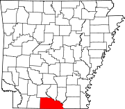 | |
| Town | ||
| CDPs | ||
| Other unincorporated communities | ||
