
Miller County, Arkansas
Miller County | |
|---|---|
 Miller County Courthouse in Texarkana | |
 Location within the U.S. state of Arkansas | |
 Arkansas's location within the U.S. | |
| Coordinates: 33°19′40″N 93°52′38″W / 33.327777777778°N 93.877222222222°W | |
| Country | |
| State | |
| Founded | April 1, 1820; recreated December 22, 1874, following abolishment in 1838 |
| Named for | James Miller[1] |
| Seat | Texarkana |
| Largest city | Texarkana |
| Area | |
| • Total | 637.48 sq mi (1,651.1 km2) |
| • Land | 623.98 sq mi (1,616.1 km2) |
| • Water | 13.5 sq mi (35 km2) 2.1% |
| Population | |
| • Total | 42,600 |
| • Density | 67/sq mi (26/km2) |
| Time zone | UTC−6 (Central) |
| • Summer (DST) | UTC−5 (CDT) |
| Website | www |
Miller County is a county located in the southwestern corner of the U.S. state of Arkansas. As of the 2020 census, the population was 42,600.[3] The county seat is Texarkana.[4]
References[change | change source]
- ↑ Gannett, Henry (1905). The Origin of Certain Place Names in the United States. U.S. Government Printing Office. p. 208.
- ↑ Arkansas State Highway and Transportation Department in cooperation with the U.S. Department of Transportation (2014-10-16). Arkansas County Polygons (SHP file) (Map). Arkansas GIS Office. Retrieved January 1, 2017.
- ↑ 3.0 3.1 "QuickFacts: Miller County, Arkansas". United States Census Bureau. Retrieved August 8, 2023.
- ↑ "Find a County". National Association of Counties. Retrieved 2011-06-07.
Municipalities and communities of Miller County, Arkansas, United States | ||
|---|---|---|
| Cities | 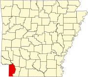 | |
| Town | ||
| CDP | ||
| Other unincorporated communities | ||
