
Lee County, Alabama
Lee County | |
|---|---|
.jpg) Main façade of Lee Courthouse, 2009 | |
| Motto: "The Heart of Dixie" | |
 Location within the U.S. state of Alabama | |
 Alabama's location within the U.S. | |
| Coordinates: 32°36′05″N 85°21′13″W / 32.601388888889°N 85.353611111111°W | |
| Country | |
| State | |
| Founded | December 5, 1866 |
| Named for | General Robert E. Lee |
| Seat | Opelika |
| Largest city | Auburn |
| Area | |
| • Total | 616 sq mi (1,600 km2) |
| • Land | 608 sq mi (1,570 km2) |
| • Water | 8.3 sq mi (21 km2) 1.3% |
| Population | |
| • Total | 174,241 |
| • Density | 280/sq mi (110/km2) |
| Time zone | UTC−6 (Central) |
| • Summer (DST) | UTC−5 (CDT) |
| Website | www |
Lee County is a county in the U.S. state of Alabama. As of the 2020 census, the population was 174,241.[1] The county seat is Opelika,[2] and the largest city is Auburn. The county is named for General Robert E. Lee (1807–1870), who served as General in Chief of the Armies of the Confederate States in 1865.[3]
References[change | change source]
- ↑ 1.0 1.1 "QuickFacts: Lee County, Alabama". United States Census Bureau. Retrieved August 8, 2023.
- ↑ "Find a County". National Association of Counties. Retrieved June 7, 2011.
- ↑ Gannett, Henry (1905). The Origin of Certain Place Names in the United States (Report). U.S. Geological survey. Bulletin no. 258 (2nd ed.). Washington: Government Printing Office. p. 184. LCCN 05000751. OCLC 1156805 – via United States Geological Survey.
Municipalities and communities of Lee County, Alabama, United States | ||
|---|---|---|
| Cities | 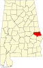 | |
| Towns | ||
| Unincorporated communities | ||
| Footnotes | ‡This populated place also has portions in an adjacent county or counties | |
| International | |
|---|---|
| National | |