
Madhya Pradesh
Madhya Pradesh | |
|---|---|
State of India | |
 Location of Madhya Pradesh in India | |
 Map of Madhya Pradesh | |
| Country | |
| Region | West India |
| Area | |
| • Total | 308,252 km2 (119,017 sq mi) |
| Population (2011) | |
| • Total | 72,626,809[1] |
| Time zone | UTC+05:30 (IST) |
Madhya Pradesh is a state in the Republic of India. The state has an area of 119,016 sq mi (308,250 km2). It is bigger than Italy but smaller than Oman. About 70,000,000 people live there. In traditional Indian geography it falls under the West Indian zone. The capital of the state is Bhopal.
The largest city is Indore. Other main cities are Jabalpur and Ujjain. Ujjain is well known for mythological reasons. Mandav, Bhojpur and Panchmadi are the main tourist attractions.
To the north of Madhya Pradesh is the state of Uttar Pradesh and to the northwest is the state of Rajasthan, while Maharashtra is to the southwest.
Provincial symbols of Madhya Pradesh[change | change source]
-
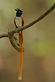 Provincial bird of Madhya Pradesh
 -
 Provincial animal of Madhya Pradesh
 -
 Provincial tree of Madhya Pradesh
 -
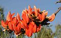 Provincial flower of Madhya Pradesh


References[change | change source]
- ↑ "Madhya Population 2011 - 2022". www.census2011.co.in. Retrieved 2022-03-06.
Wikimedia Commons has media related to Madhya Pradesh.
| States |
Andhra Pradesh • Arunachal Pradesh • Assam • Bihar • Chhattisgarh • Goa • Gujarat • Haryana • Himachal Pradesh • Jharkhand • Karnataka • Kerala • Madhya Pradesh • Maharashtra • Manipur • Meghalaya • Mizoram • Nagaland • Odisha • Punjab • Rajasthan • Sikkim • Tamil Nadu • Telangana • Tripura • Uttar Pradesh • Uttarakhand • West Bengal | |
|---|---|---|
| Union Territories | ||