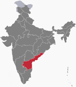
Andhra Pradesh
Andhra Pradesh (/ˌɑːndrə prəˈdɛʃ/) (![]() pronunciation (help·info)) is a state in the Republic of India. It has a population of 75,727,000 people according to the census of 2001. The eastern boundary is a 600 miles (970 km) coastline along the Bay of Bengal. Its latitude and longitude is 17.3660°N and 78.4760°E. The state has an area of 106,195 square miles (275,040 km2). It is bigger than Burkina Faso but smaller than Ecuador. In traditional Indian geography it falls under the South Indian zone. It was divided into Andhra Pradesh and Telangana in 2014, because of the Andhra Pradesh Reorganization Act 2014. According to this Act, both states will have the same capital city Hyderabad, for a period of 10 years.[6] The present Chief Minister of the state is Y. S. Jagan Mohan Reddy of the YSR Party.
pronunciation (help·info)) is a state in the Republic of India. It has a population of 75,727,000 people according to the census of 2001. The eastern boundary is a 600 miles (970 km) coastline along the Bay of Bengal. Its latitude and longitude is 17.3660°N and 78.4760°E. The state has an area of 106,195 square miles (275,040 km2). It is bigger than Burkina Faso but smaller than Ecuador. In traditional Indian geography it falls under the South Indian zone. It was divided into Andhra Pradesh and Telangana in 2014, because of the Andhra Pradesh Reorganization Act 2014. According to this Act, both states will have the same capital city Hyderabad, for a period of 10 years.[6] The present Chief Minister of the state is Y. S. Jagan Mohan Reddy of the YSR Party.
Andhra Pradesh has a gross domestic product (GDP) of 123,560 (in millions of US dollars). That makes it the third largest state in India in terms of GDP, after Maharashtra and Uttar Pradesh. Most of this money comes from agriculture. Andhra Pradesh is sometimes called the "Rice Bowl of India", as a very large amount of rice or paddy is grown in the coastal plains of the state. Recently the state is also involved in newer businesses like biotechnology and information technology.[7]
Provincial symbols of Andhra Pradesh[change | change source]
-
Provincial bird of Andhra Pradesh
-
Provincial animal of Andhra Pradesh
-
Provincial tree of Andhra Pradesh
-
Provincial flower of Andhra Pradesh
References[change | change source]
- ↑ "appointed S. Abdul Nazeer is new Governor of Andhra Pradesh". Zee News. 16 July 2019. Archived from the original on 16 July 2019. Retrieved 16 July 2019.
- ↑ "S. Abdul Nazeer appointed as Governor of Andhra Pradesh". The News Minute. 24 February 2023. Archived from the original on 16 July 2019. Retrieved 24 February 2023.
- ↑ "Demography" (PDF). Official portal of Andhra Pradesh Government. Government of Andhra Pradesh. Archived from the original (PDF) on 14 July 2014. Retrieved 10 June 2014.
- ↑ "MOSPI Gross State Domestic Product". Ministry of Statistics and Programme Implementation, Government of India. 1 August 2019. Retrieved 16 September 2019.
- ↑ "Sub-national HDI – Area Database". Global Data Lab. Institute for Management Research, Radboud University. Archived from the original on 23 September 2018. Retrieved 25 September 2018.
- ↑ "Andhra Pradesh bifurcation - a perspective". Ernst Young. Archived from the original on 1 July 2019. Retrieved 1 July 2019.
- ↑ "Tour to Andhra Pradesh - Rice Bowl of India". www.discoveredindia.com. Retrieved 2019-03-09.


