Tornado Alley


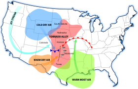
Tornado Alley is a colloquial term most often used to refer to the area of the United States in which tornadoes happen more than in any other part of the country.[1] The 1974 super tornado outbreak with 148 tornadoes, took place in Georgia, Illinois, Indiana, Kentucky, Michigan, Mississippi, North Carolina, Ohio, South Carolina, Tennessee, Virginia, and West Virginia.
States such as Minnesota, Wisconsin, Illinois, Indiana, and Ohio are sometimes included in Tornado Alley.[2] Research suggests that tornadoes are happening more often in the northern parts of Tornado Alley where it reaches the Canadian prairies.[3]
Tornado alley geographical area[change | change source]

Over the years, the location(s) of Tornado Alley have not been clearly defined. No definition of tornado alley has ever been officially chosen by the National Weather Service (NWS).[4] Thus, differences in the place are because of the different criteria used.[4][5]
The National Severe Storms Laboratory (NSSL) FAQ says that "Tornado Alley" is a term used by the media as a reference to areas that have mroe tornadoes.[4] A study of 1921–1995 tornadoes concluded almost one-fourth of all significant tornadoes happen in this area.[6]
No state has no tornadoes; however, they happen more often in the Central United States, between the Rocky Mountains and Appalachian Mountains.[4]
Another criterion for the location of Tornado Alley (or Tornado Alleys) can be where the strongest tornadoes happen more often.[7]
Origin of the term[change | change source]
The term "tornado alley" was first used in 1952 by U.S. Air Force meteorologists Major Ernest J. Fawbush (1915–1982) and Captain Robert C. Miller (1920–1998). They used it as the title of a research project[8] to study severe weather in parts of Texas and Oklahoma.[9]
How many tornadoes[change | change source]
The average tornado stays on ground for only 5 minutes. These figures, reported by the National Climatic Data Center for the period between 1991 and 2010, show the seventeen U.S. states with the most average number of tornadoes per 10,000 square miles (25,899.9 km2) per year.[10]
- Florida: 12.2
- Kansas: 11.7
- Maryland: 9.9
- Illinois: 9.7
- Mississippi: 9.2
- Iowa: 9.1
- Oklahoma: 9
- South Carolina: 9
- Alabama: 8.6
- Louisiana: 8.5
- Arkansas: 7.5
- Nebraska: 7.4
- Missouri: 6.5
- North Carolina: 6.4
- Tennessee: 6.2
- Indiana: 6.1
- Texas: 5.9
Canadian tornadoes[change | change source]
About half of all Canadian tornadoes hit the Canadian prairies and Northern Ontario as far east as Lake Superior. Together, these areas make up the northernmost border of the U.S. Tornado Alley. Tornadoes up to EF5 in strength have been found in this region.[11]
Schools in Tornado Alley often have tornado drills, and many homes may have tornado shelters where people can go for safety.
References[change | change source]
- ↑ Glickman, Todd S. (2000). Glossary of Meteorology (2nd ed.). Boston: American Meteorological Society. ISBN 978-1878220349. Archived from the original on 2015-05-18.
- ↑ "Tornado Alley" (PDF). Smithsonian Institution. Archived (PDF) from the original on October 18, 2013. Retrieved October 2, 2013.
- ↑ "The new tornado alley - University of Saskatchewan". Archived from the original on 2014-01-18. Retrieved 2014-01-16.
- ↑ 4.0 4.1 4.2 4.3 "Severe Weather 101: Tornado FAQ". National Severe Storms Laboratory. NOAA. January 29, 2007. Archived from the original on October 30, 2013. Retrieved September 29, 2013.
- ↑ "Tornado FAQ". Storm Prediction Center. NOAA. January 29, 2007. Archived from the original on March 2, 2012. Retrieved September 29, 2013.
- ↑ "Climatology Risk of Strong and Violent Tornadoes In the United States". Northern Illinois University & NOAA/ERL/National Severe Storms Laboratory. January 29, 2007. Archived from the original on May 3, 2007. Retrieved April 26, 2007.
- ↑ Taking Shelter from the Storm: Building a Safe Room for Your Home or Small Business (pdf) (Technical report) (4th ed.). FEMA. December 2014. P-320. Archived (PDF) from the original on July 21, 2015. Retrieved July 18, 2015.
- ↑ "Essay Tornado". Major Ernest J. Fawbush and Captain Robert C. Miller. Archived from the original on November 3, 2016. Retrieved November 25, 2015.
- ↑ See:
- Jeremy Singer-Vine (May 23, 2011) "How did "Tornado Alley" get its name?," Archived 2012-05-28 at the Wayback Machine Slate (on-line magazine).
- John P. Gagan, Alan Gerard, and John Gordon (December 2010) "A historical and statistical comparison of "Tornado Alley" to "Dixie Alley", " Archived 2012-05-17 at the Wayback Machine National Weather Digest, vol. 34, no. 2, pages 146-155; see especially page 146.
- "Weather officers commended," Take-Off (newspaper of Tinker Air Force Base; Midwest City, Oklahoma), January 16, 1953.
- Results of search of Google Books for "tornado alley".
- ↑ "Average Annual Number of EF0-EF5 Tornadoes per 10,000 square miles during 1991 - 2010" (gif). National Climatic Data Center. U.S. Tornado Climatology: NOAA.gov. Archived from the original on October 29, 2013. Retrieved October 26, 2013.
- ↑ http://ec.gc.ca/meteo-weather/default.asp?lang=En&n=6C5D4990-1#tornadoes Archived 2016-08-02 at the Wayback Machine
Other websites[change | change source]
- NSSL Tornado Climatology
- Climatological Estimates of Local Daily Tornado Probability for the United States
- Tornado hazards in the United States
- Statistical modeling of tornado intensity distributions
