
Gough Island
 View of Gough Island | |
 | |
| Geography | |
|---|---|
| Location | South Atlantic Ocean |
| Coordinates | 40°19′0″S 9°56′0″W / 40.31667°S 9.93333°W |
| Archipelago | Tristan da Cunha |
| Area | 91 km2 (35 sq mi) |
| Length | 13 km (8.1 mi) |
| Width | 7 km (4.3 mi) |
| Highest elevation | 910 m (2990 ft) |
| Highest point | Edinburgh Peak |
| Administration | |
United Kingdom | |
| St Helena, Ascension and Tristan da Cunha | |
| Criteria | Natural: (vii), (x) |
| Reference | 740 |
| Inscription | 1995 (19th Session) |
| Designated | 20 November 2008 |
| Reference no. | 1868[1] |

Gough Island (/ɡɒf/), historically known as Gonçalo Álvares, is a rugged volcanic island in the South Atlantic Ocean. It is a dependency of Tristan da Cunha. It is part of the British overseas territory of Saint Helena, Ascension and Tristan da Cunha. It is part of the UNESCO World Heritage Site of Gough and Inaccessible Islands.
It is about 400 km (250 mi) south-east of the Tristan da Cunha archipelago (which includes Nightingale Island and Inaccessible Island), 2,400 km (1,500 mi), north-east from South Georgia Island, 2,700 km (1,700 mi) west from Cape Town. It is over 3,200 km (2,000 mi) from the nearest point of South America.
Nobody lives on Gough Island except for the workers of a weather station, which is usually six people. The South African National Antarctic Programme has maintained the island with British permission since 1956. It is one of the most remote places with a people always being there.
Name[change | change source]
The island was first named Ilha de Gonçalo Álvares on Portuguese maps. It was named Gough Island after the British mariner Captain Charles Gough of the Richmond, who first saw the island in 1732. Confusion of the unusual Portuguese saint name Gonçalo with Spanish Diego led to the wrong name Diego Alvarez Island in English-language sources from the 1800s to 1930s.[2][3][4]
However, the most likely explanation is that it was simply a misreading of 'Is de Go Alvarez', the name by which the island is represented on some of the early charts, the 'de Go' mutating into 'Diego'.[5]
History[change | change source]
The details of the discovery of Gough Island are unclear, but the most likely occasion is July 1505 by the Portuguese explorer Gonçalo Álvares.[6] Maps during the next three centuries named the island after him. On some later maps, this was erroneously given as Diego Alvarez.
According to some historians, the British merchant Anthony de la Roché was the first to land on the island in the austral autumn of 1675.[7][8][9]
Charles Gough rediscovered the island on 3 March 1732. He thought it was a new find.[10] It had been named Gonçalo Álvares since 1505 after the captain of Vasco da Gama's flagship on his epic voyage to the east. It was under this name that it was marked with reasonable accuracy on the charts of the South Atlantic during the following 230 or so years.
Then, in 1732, Captain Gough of the British ship Richmond reported the discovery of a new island. He placed it 400 miles to the east of Gonçalo Álvares. Fifty years later, cartographers realised that the two islands were the same. Despite the priority of the Portuguese discovery, and the greater accuracy of the position given by them, "Gough's Island" was the name adopted.[11]
In the early 19th century, sealers briefly inhabited the island. The earliest known example is a sealing gang from the U.S. ship Rambler (Captain Joseph Bowditch) which remained on the island in the 1804–1805 season.[12] The sealing era lasted from 1804 to 1910 during which 34 sealing vessels are known to have visited the island, one of which was lost offshore.[13]
The Scottish National Antarctic Expedition on the Scotia made the first visit to the island by a scientific party on 21 April 1904, when William Speirs Bruce and others collected specimens.[14] The Shackleton–Rowett Expedition also stopped at the island in 1922.[15]
Gough Island was formally claimed in 1938 for Britain, during a visit by HMS Milford of the Royal Navy.[16] In 1995, the island was inscribed as a UNESCO World Heritage Site. In 2004, the site was extended to include Inaccessible Island and renamed Gough and Inaccessible Islands.
Gough Island is the only place outside South America from which the solar eclipse of September 12, 2034, will be visible; the centre of the path of totality crosses over the island.
Geography and geology[change | change source]
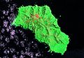
Gough Island is roughly rectangular with a length of 13 km (8.1 mi) and a width of 7 kilometres (4.3 mi). It has an area of 91 km2 (35 sq mi) and rises to heights of over 900 m (3,000 ft) above sea level.[17] Topographic features include the highest peak, Edinburgh Peak, Hags Tooth, Mount Rowett, Sea Elephant Bay, Quest Bay, and Hawkins Bay.
It includes small satellite islands and rocks such as Southwest Island, Saddle Island (South), Tristiana Rock, Isolda Rock (West), Round Island, Cone Island, Lot's Wife, Church Rock (North), Penguin Island (Northeast), and The Admirals (East).
Climate[change | change source]
According to the Köppen system, Gough Island features an oceanic climate (Cfb). Gough Island's temperatures are between 11 °C (52 °F) and 17 °C (63 °F) during the day year-round, due to its isolated position far out in the Atlantic Ocean. The Atlantic is much cooler in the southern hemisphere than the northern, but frosts are still very rare. As a result, summers are not very hot. It features a similar climate to the Fiordland area of New Zealand, the west coast of Scotland, or the Alaskan Panhandle. Precipitation is high during the entire year, and sunshine hours are few. Snow falls in the interior, but is rare at sea level.[18]
| Climate data for Gough Island (1961–1990, extremes 1956–1990) | |||||||||||||
|---|---|---|---|---|---|---|---|---|---|---|---|---|---|
| Month | Jan | Feb | Mar | Apr | May | Jun | Jul | Aug | Sep | Oct | Nov | Dec | Year |
| Record high °C (°F) | 26.4 (79.5) |
25.7 (78.3) |
25.9 (78.6) |
22.6 (72.7) |
20.5 (68.9) |
20.6 (69.1) |
19.3 (66.7) |
21.7 (71.1) |
19.3 (66.7) |
21.4 (70.5) |
23.9 (75.0) |
25.1 (77.2) |
26.4 (79.5) |
| Average high °C (°F) | 17.2 (63.0) |
17.4 (63.3) |
16.9 (62.4) |
15.4 (59.7) |
13.7 (56.7) |
12.4 (54.3) |
11.5 (52.7) |
11.2 (52.2) |
11.5 (52.7) |
12.9 (55.2) |
14.9 (58.8) |
16.2 (61.2) |
14.3 (57.7) |
| Daily mean °C (°F) | 13.9 (57.0) |
14.4 (57.9) |
13.9 (57.0) |
12.8 (55.0) |
11.3 (52.3) |
10.0 (50.0) |
9.1 (48.4) |
8.9 (48.0) |
8.9 (48.0) |
10.1 (50.2) |
11.9 (53.4) |
13.2 (55.8) |
11.5 (52.7) |
| Average low °C (°F) | 11.1 (52.0) |
11.6 (52.9) |
11.3 (52.3) |
10.4 (50.7) |
8.9 (48.0) |
7.6 (45.7) |
6.6 (43.9) |
6.5 (43.7) |
6.6 (43.9) |
7.8 (46.0) |
9.4 (48.9) |
10.3 (50.5) |
9.0 (48.2) |
| Record low °C (°F) | 5.3 (41.5) |
5.1 (41.2) |
4.8 (40.6) |
3.7 (38.7) |
1.4 (34.5) |
0.1 (32.2) |
−0.9 (30.4) |
−2.7 (27.1) |
0.2 (32.4) |
0.5 (32.9) |
2.4 (36.3) |
4.1 (39.4) |
−2.7 (27.1) |
| Average precipitation mm (inches) | 210 (8.3) |
183 (7.2) |
254 (10.0) |
276 (10.9) |
286 (11.3) |
310 (12.2) |
273 (10.7) |
304 (12.0) |
270 (10.6) |
249 (9.8) |
213 (8.4) |
241 (9.5) |
3,069 (120.9) |
| Average precipitation days (≥ 1.0 mm) | 16 | 13 | 18 | 19 | 21 | 22 | 23 | 21 | 20 | 18 | 16 | 18 | 225 |
| Average relative humidity (%) | 81 | 82 | 82 | 82 | 82 | 83 | 83 | 83 | 81 | 81 | 81 | 81 | 82 |
| Mean monthly sunshine hours | 183.8 | 148.8 | 123.3 | 95.6 | 83.7 | 60.4 | 71.7 | 87.5 | 101.6 | 128.5 | 161.4 | 182.9 | 1,429.2 |
| Source 1: NOAA,[19] Deutscher Wetterdienst (extremes)[20] | |||||||||||||
| Source 2: climate-charts.com[21] | |||||||||||||
Weather station[change | change source]
A weather station has been running on Gough Island since 1956. It is operated as part of the network of the South African Weather Service. Because cold fronts approach South Africa from the south-west, the Gough station is particularly important in forecasting winter weather. Initially it was housed in the station at The Glen, but moved in 1963 to the South lowlands of the island, more precisely 40°20′57.68″S 9°52′49.13″W / 40.3493556°S 9.8803139°W. The new location improved the validity and reliability of the data acquired for use in modeling.
Human presence[change | change source]
Each year a new overwintering team arrives by ship from Cape Town (beginning in 2012, the S. A. Agulhas II) to staff the weather station and perform scientific research. The team for a particular year may be termed as "Gough" and an expedition number: for example, the 1956 team were "Gough 01", and the team for 2013 were "Gough 58". Each new team directly replaces the departing one, thereby maintaining a continual human presence on the island.[22][23]
A team normally consists of:
- A senior meteorologist
- Two junior meteorologists
- A radio technician
- A medic
- A diesel mechanic
- A number of biologists (depending on ongoing research projects)
The team is supplied with enough food to last the whole year. People and cargo are landed either by helicopter, from a helideck-equipped supply ship, or by a fixed crane atop a cliff near the station (a place aptly called "Crane Point").
In 2014 a member of the research team choked to death on the island and his body was taken back to South Africa.[24]
Maps[change | change source]
-
 Relief map
 -
 Orthographic projection
 -
 Satellite map


References[change | change source]
- ↑ "Gough Island". Ramsar Sites Information Service. Retrieved 25 April 2018.
- ↑ Report on the geological collections made during the voyage of the ... British Museum (Natural History), Walter Campbell Smith, British Museum (Natural History) – 1930 "DIEGO ALVAREZ OR GOUGH ISLAND. By W. Campbell Smith. Gough Island, as it seems to be more usually called, lies about 200 miles south of the Tristan da Cunha group in latitude 40° S., longitude 10° W.1 It is about 8 miles long by 3 ..."
- ↑ Plants of Gough Island: (Diego Alvarez) Erling Christophersen – 1934
- ↑ The Antarctic dictionary: a complete guide to Antarctic English – Page 150 Bernadette Hince – 2000 -"I went for adventure. to have fun, Gough Island Gough Island was named I. de Goncalo Alvarez on early maps. after its discoverer. Portuguese navigator Goncalo Alvarez. The name was later corrupted to I. Diego Alvarez. and there was confusion about the locality. It was renamed after Captain Charles Gough of the British barque Richmond. who sighted the island in 1713."
- ↑ Raymond John Howgego, Historical Encyclopedia of Atlantic Vigias, London, 2015
- ↑ Hänel, Christine (October 2008). "South African Journal of Science – Gough Island 500 years after its discovery: a bibliography of scientific and popular literature 1505 to 2005". South African Journal of Science. 104 (9–10). Scielo.org.za: 329–332. Retrieved 2012-10-25.
- ↑ Wace N.M. (1969). "The discovery, exploitation and settlement of the Tristan da Cunha Islands". Proceedings of the Royal Geographical Society of Australasia (South Australian Branch). 10: 11–40.
- ↑ Capt. Francisco de Seixas y Lovera, Descripcion geographica, y derrotero de la region austral Magallanica. Que se dirige al Rey nuestro señor, gran monarca de España, y sus dominios en Europa, Emperador del Nuevo Mundo Americano, y Rey de los reynos de la Filipinas y Malucas, Madrid, Antonio de Zafra, 1690. (Relevant fragment)
- ↑ J.-F.G. de la Pérouse, F.A.M. de la Rúa. A Voyage Round the World, Performed in the Years 1785, 1786, 1787, and 1788, by the Boussole and Astrolabe: Under the Command of J.-F.G. de la Pérouse, Volume 1. London: Lackington, Allen, and Company, 1807. pp.71-81.
- ↑ Gough's log is preserved in the East India Collection at the British Library. The entry for 3 March 1732 is printed in Gabriel Wright (pub.), "A New Nautical Directory for the East-India and China Navigation", 7th edn, London, 1804, p. 394.
- ↑ Heaney, J.B., Holdgate, M.W. (1957). The Gough Island Scientific Survey. The Geographical Journal, Vol. 123, No. 1, pp. 20–31
- ↑ R.K. Headland (Ed.) Historical Antarctic Sealing Industry, Scott Polar Research Institute (University of Cambridge), 2018, p.176. ISBN 978-0-901021-26-7
- ↑ Headland, p.167.
- ↑ Rudmose Brown, R. N.; Pirie, J. H.; Mossman, R. C. (2002). The Voyage of the Scotia. Edinburgh: Mercat Press. pp. 132–34. ISBN 978-1-84183-044-5.
- ↑ Wild, Frank (1923). "Chapter XIII: Diego Alvarez or Gough Island". Shackleton's last voyage: The Story of the Quest. Retrieved 18 December 2016.
- ↑ "Gough Island, South Atlantic Ocean". Btinternet.com. Archived from the original on 12 October 2012. Retrieved 2012-10-25.
- ↑ "Gough Island". Sanap.ac.za. Archived from the original on 12 September 2017. Retrieved 2012-10-25.
- ↑ Riffenburgh, Beau (20 May 2018). Encyclopedia of the Antarctic. Taylor & Francis. ISBN 978-0-415-97024-2 – via Google Books.
- ↑ "Gough Island Climate Normals 1961−1990". National Oceanic and Atmospheric Administration. Retrieved November 21, 2013.
- ↑ "Klimatafel von Gough Island / Südatlantik / Großbritannien" (PDF). Baseline climate means (1961–1990) from stations all over the world (in German). Deutscher Wetterdienst. Retrieved November 18, 2016.
- ↑ "Climate Statistics for Gough Island, South Africa". 20 February 1998. Archived from the original on 20 August 2016. Retrieved 7 March 2012.
- ↑ "South Africa National Antarctic Programme - Gough Island Teams" Archived 12 September 2017 at the Wayback Machine, Retrieved 12 February 2014
- ↑ Chris Bell, "Chris Bell's Blog from Gough 58", Retrieved 12 February 2014
- ↑ "SA man dies on Gough Island". www.enca.com. Archived from the original on 2016-12-14. Retrieved 2020-08-14.
Other websites[change | change source]
- www.goughisland.com - The Gough Island Restoration Project website
- Gough Island Gallery
- Gough and Inaccessible Islands - UNESCO wildlife reserve publication
- Photographs of Gough Island - Flickr publication by Chantal van Staden.

| Authority control: National |
|---|