Demopolis, Alabama
Appearance
Demopolis, Alabama | |
|---|---|
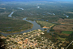
 Aerial view of Demopolis. The confluence of the Tombigbee and Black Warrior rivers is visible in the center of the picture. View is looking to the northwest. | |
| Nickname(s): City of the People, Jewel of the Black Belt, The River City, The Canebrake, Demop | |
 Location in Marengo County, Alabama | |
| Coordinates: 32°30′34″N 87°50′14″W / 32.50944°N 87.83722°W | |
| Country | United States |
| State | Alabama |
| County | Marengo |
| Area | |
| • Total | 18.07 sq mi (46.79 km2) |
| • Land | 17.75 sq mi (45.96 km2) |
| • Water | 0.32 sq mi (0.84 km2) |
| Elevation | 121 ft (37 m) |
| Population | |
| • Total | 7,162 |
| • Density | 404/sq mi (155.8/km2) |
| Time zone | UTC-6 (Central (CST)) |
| • Summer (DST) | UTC-5 (CDT) |
| ZIP code | 36732 |
| Area code | 334 |
| FIPS code | 01-20296 |
| GNIS feature ID | 0117222 |
| Website | www |
Demopolis is the largest city in Marengo County, Alabama, United States. At the 2020 census the population was 7,162.[2] It is the birthplace of A. G. Gaston, a successful black businessman and financial supporter of the American civil rights movement.
References
[change | change source]- ↑ "2021 U.S. Gazetteer Files". United States Census Bureau. Retrieved April 6, 2022.
- ↑ 2.0 2.1 "Demopolis city, Alabama: 2020 DEC Redistricting Data (PL 94-171)". U.S. Census Bureau. Retrieved April 7, 2022.
Wikimedia Commons has media related to Demopolis, Alabama.


