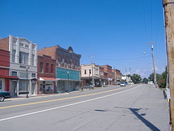
Stevenson, Alabama
Appearance
Stevenson, Alabama | |
|---|---|
 Historic District | |
 Location of Stevenson in Jackson County, Alabama. | |
| Coordinates: 34°52′10″N 85°49′55″W / 34.86944°N 85.83194°W | |
| Country | United States |
| State | Alabama |
| County | Jackson |
| Area | |
| • Total | 8.10 sq mi (20.98 km2) |
| • Land | 7.70 sq mi (19.93 km2) |
| • Water | 0.41 sq mi (1.05 km2) |
| Elevation | 653 ft (199 m) |
| Population | |
| • Total | 1,955 |
| • Density | 254.06/sq mi (98.10/km2) |
| Time zone | UTC-6 (Central (CST)) |
| • Summer (DST) | UTC-5 (CDT) |
| ZIP code | 35772 |
| Area code | 256 |
| FIPS code | 01-73080 |
| GNIS feature ID | 0127370 |
| Website | www |
Stevenson is a city in Jackson County, Alabama, United States, and is included in the Huntsville-Decatur Combined Statistical Area. As of the 2020 census, the population of the city is 1,955.[2]
References
[change | change source]- ↑ "2020 U.S. Gazetteer Files". United States Census Bureau. Retrieved October 29, 2021.
- ↑ 2.0 2.1 "Stevenson city, Alabama". United States Census Bureau. Retrieved September 5, 2023.


