Saraland, Alabama
Saraland, Alabama | |
|---|---|
| Motto: "Gateway to Progress" | |
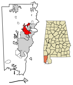
 Location in Mobile County, Alabama | |
| Coordinates: 30°49′31″N 88°5′31″W / 30.82528°N 88.09194°W | |
| Country | United States |
| State | Alabama |
| County | Mobile |
| Incorporated | 1957 |
| Government | |
| • Type | Mayor–council |
| Area | |
| • Total | 32.37 sq mi (83.84 km2) |
| • Land | 32.15 sq mi (83.27 km2) |
| • Water | 0.22 sq mi (0.57 km2) |
| Elevation | 13 ft (4 m) |
| Population | |
| • Total | 16,171 |
| • Density | 502.97/sq mi (194.20/km2) |
| Time zone | UTC-6 (Central (CST)) |
| • Summer (DST) | UTC-5 (CDT) |
| ZIP code | 36571 |
| Area code | 251 |
| FIPS code | 01-68160 |
| GNIS feature ID | 0153329 |
| Website | www |
Saraland is a city in Mobile County, Alabama, in the United States. It is a suburb of Mobile, Alabama, and part of the Mobile metropolitan statistical area. As of the 2020 census, the population of the city was 16,171.[2] Saraland is the third largest city in Mobile County.
References[change | change source]
- ↑ "2021 U.S. Gazetteer Files". United States Census Bureau. Retrieved April 21, 2022.
- ↑ 2.0 2.1 "Saraland city, Alabama: 2020 DEC Redistricting Data (PL 94-171)". U.S. Census Bureau. Retrieved April 21, 2022.


