
Southside, Alabama
Southside, Alabama | |
|---|---|
 Sunset over the Coosa River in Southside | |
| Motto(s): Rich in Hospitality and Genuine Southern Character, The Loveliest Village on the Coosa | |
 Location in Etowah County and the state of Alabama | |
| Coordinates: 33°54′13″N 86°1′34″W / 33.90361°N 86.02611°W | |
| Country | United States |
| State | Alabama |
| Counties | Etowah |
| Government | |
| • Type | Mayor-Council (5 members) |
| Area | |
| • Total | 19.27 sq mi (49.92 km2) |
| • Land | 19.11 sq mi (49.49 km2) |
| • Water | 0.17 sq mi (0.43 km2) |
| Elevation | 548 ft (167 m) |
| Population | |
| • Total | 9,426 |
| • Density | 493.28/sq mi (190.45/km2) |
| Time zone | UTC-6 (Central (CST)) |
| • Summer (DST) | UTC-5 (CDT) |
| ZIP code | 35907 |
| Area code | 256 |
| FIPS code | 01-71832 |
| GNIS feature ID | 2405499[2] |
| Website | www |
Southside is a city in Etowah county in the U.S. state of Alabama. It is part of the Gadsden Metropolitan Statistical Area. The population was 9,426 at the 2020 census.[3]
References
[change | change source]- ↑ "2020 U.S. Gazetteer Files". United States Census Bureau. Retrieved October 29, 2021.
- ↑ 2.0 2.1 U.S. Geological Survey Geographic Names Information System: Southside, Alabama
- ↑ 3.0 3.1 "Southside city, Alabama". United States Census Bureau. Retrieved September 5, 2023.
Municipalities and communities of Calhoun County, Alabama, United States | ||
|---|---|---|
| Cities | 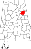 | |
| Towns | ||
| CDPs | ||
| Unincorporated communities | ||
| Ghost town | ||
| Footnotes | ‡This populated place also has portions in an adjacent county or counties | |
Municipalities and communities of Etowah County, Alabama, United States | ||
|---|---|---|
| Cities |  | |
| Towns | ||
| CDPs | ||
| Unincorporated communities | ||
| Former City | ||
| Footnotes | ‡This populated place also has portions in an adjacent county or counties | |
