Selma, Alabama
Appearance
Selma, Alabama | |
|---|---|
From top, left to right: St. James Hotel and Water Avenue; Edmund Pettus Bridge; National Voting Rights Museum and Institute | |
| Nickname(s): Queen City of the Black Belt, Butterfly Capital of Alabama | |
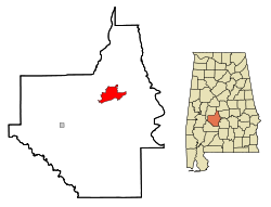
 Location in Dallas County and the state of Alabama | |
| Coordinates: 32°24′59″N 87°1′29″W / 32.41639°N 87.02472°W[1] | |
| Country | United States |
| State | Alabama |
| County | Dallas |
| Founded | 1815 |
| Incorporated | 1820 |
| Government | |
| • Type | Mayor–council |
| Area | |
| • Total | 14.40 sq mi (37.30 km2) |
| • Land | 13.81 sq mi (35.77 km2) |
| • Water | 0.59 sq mi (1.54 km2) |
| Elevation | 135 ft (41 m) |
| Population | |
| • Total | 17,971 |
| • Density | 1,301.40/sq mi (502.46/km2) |
| Demonym | Selmarian |
| Time zone | UTC−6 (CST) |
| • Summer (DST) | UTC−5 (CDT) |
| ZIP Codes | 36701-36703 |
| Area code | 334 |
| FIPS code | 01-69120 [1] |
| GNIS ID | 163940 [1] |
| Website | selma-al.gov |
Selma is a city in and the county seat of Dallas County, Alabama, United States, located on the banks of the Alabama River. The population was 17,971 at the 2020 census.[3] The city is best known for the Selma to Montgomery marches, three civil rights marches that began in the city.
Notable residents
[change | change source]- Jeff Sessions, U.S. Senator
References
[change | change source]- ↑ 1.0 1.1 1.2 1.3 "Selma, Alabama". Geographic Names Information System. United States Geological Survey.
- ↑ "2020 U.S. Gazetteer Files". United States Census Bureau. Retrieved October 29, 2021.
- ↑ 3.0 3.1 "Selma city, Alabama". United States Census Bureau. Retrieved September 5, 2023.
Wikimedia Commons has media related to Selma, Alabama.


