Conakry
Conakry, Guinea
Kɔnakiri | |
|---|---|
 Conakry, Guinea | |
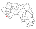
 Map of Guinea showing the location of Conakry. | |
| Coordinates: 9°31′N 13°42′W / 9.517°N 13.700°W | |
| Country | Guinea |
| Population (2007) | |
| • Total | 2,000,000 |
| Time zone | UTC+1 (CET) |
| • Summer (DST) | UTC+1 (CEST) |
Conakry or Konakry is the capital and largest city of Guinea. The city is a port on the Atlantic Ocean. The population of Conakry is about 2 million people.[1]
History[change | change source]
Conakry was first settled on Tombo Island. It later spread to the Kaloum Peninsula. The city was founded after Britain gave the island to France in 1887. It became the capital of French Guinea in about 1904.
Economy[change | change source]
Conakry is Guinea's largest city and its administrative, communications, and economic center. The main part of the city's economy deals with the port. The port has up to date facilities for handling and storing cargo. It is used for transporting alumina and bananas. Items created in Conakry include food products and materials used for building houses.
Things to see[change | change source]

Things to see in the city include the Guinea National Museum, several markets, the Guinea Palais du Peuple (the People's Palace), Conakry Grand Mosque and the nearby Iles de Los.
The city is noted for its botanical garden. The Polytechnical Institute of Conakry is also located in Conakry.
References[change | change source]
- ↑ "Background Note: Guinea". Bureau of African Affairs, U.S. Department of State, January 2007. Accessed February 24, 2007.
