Oryol Oblast
| Oryol Oblast Орловская область (Russian) | |||
|---|---|---|---|
| — Oblast — | |||
| |||
Coordinates: 52°51′N 36°26′E / 52.850°N 36.433°E | |||
| Political status | |||
| Country | Russia | ||
| Federal district | Central[1] | ||
| Economic region | Central[2] | ||
| Established | September 27, 1937 | ||
| Administrative center | Oryol | ||
| Government (as of October 2017) | |||
| • Governor | Andrey Klychkov[3] | ||
| • Legislature | Oblast Council of People's Deputies | ||
| Statistics | |||
| Area (as of the 2002 Census)[4] | |||
| • Total | 24,652 km2 (9,518 sq mi) | ||
| Area rank | 71st | ||
| Population (2010 Census)[5] | |||
| • Total | 786,935 | ||
| • Rank | 63rd | ||
| • Density[6] | 31.92/km2 (82.7/sq mi) | ||
| • Urban | 65.5% | ||
| • Rural | 34.5% | ||
| Population (January 2022 est.) | |||
| • Total | 714,094[source?] | ||
| Time zone(s) | MSK (UTC+04:00) | ||
| ISO 3166-2 | RU-ORL | ||
| License plates | 57 | ||
| Official languages | Russian[7] | ||
| Official website | |||
Oryol Oblast (Russian: Орло́вская о́бласть, Orlovskaya oblast), also known as Orlovshchina (Russian: Орловщина) is a federal subject of Russia. Specifically it is an oblast. Its administrative center (capital city) is the city of Oryol. Population: 714,094 (Estimate 2022) (2010 Census — 786,935).[5]
Geography[change | change source]

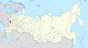
It is in the southwestern part of the Central Federal District, in the Central Russian Upland.
By area, at 24,652 km2 (9,518 sq mi) it is one of the smallest federal subjects.[8] From north to south, it goes for more than 150 km (93 mi), and from west to east—for over 200 km (120 mi).
It borders Kaluga Oblast in the north, Lipetsk Oblast in the east, Kursk Oblast in the south, and Bryansk Oblast in the west.
There are more than two thousand rivers and streams in Oryol Oblast with a total length of 9,100 km (5,700 mi).
Administrative divisions[change | change source]
- 3 cities under the oblast's jurisdiction
- 24 districts
Economy[change | change source]
The main industries in Oryol Oblast are the food and light industries, engineering and metalworking, and ferrous and nonferrous metallurgy. The engineering and metalworking industries make equipment for many industries. These include forklift trucks, construction and agricultural equipment, and machinery for municipal services.
Demographics[change | change source]


Population: 714,094 (est. 2022); 786,935 (2010 Census);[5] 860,262 (2002 Census);[9] 890,636 (1989 Census).[10]
- Ethnic composition (2010):[5]
- Russians - 96.1%
- Ukrainians - 1%
- Others - 2.9%
References[change | change source]

- ↑ Президент Российской Федерации. Указ №849 от 13 мая 2000 г. «О полномочном представителе Президента Российской Федерации в федеральном округе». Вступил в силу 13 мая 2000 г. Опубликован: "Собрание законодательства РФ", №20, ст. 2112, 15 мая 2000 г. (President of the Russian Federation. Decree #849 of May 13, 2000 On the Plenipotentiary Representative of the President of the Russian Federation in a Federal District. Effective as of May 13, 2000.).
- ↑ Госстандарт Российской Федерации. №ОК 024-95 27 декабря 1995 г. «Общероссийский классификатор экономических регионов. 2. Экономические районы», в ред. Изменения №5/2001 ОКЭР. (Gosstandart of the Russian Federation. #OK 024-95 December 27, 1995 Russian Classification of Economic Regions. 2. Economic Regions, as amended by the Amendment #5/2001 OKER. ).
- ↑ rbc.ru Putin Replaces Oryol Oblast Governor (in Russian)
- ↑ Федеральная служба государственной статистики (Federal State Statistics Service) (2004-05-21). "Территория, число районов, населённых пунктов и сельских администраций по субъектам Российской Федерации (Territory, Number of Districts, Inhabited Localities, and Rural Administration by Federal Subjects of the Russian Federation)". Всероссийская перепись населения 2002 года (All-Russia Population Census of 2002) (in Russian). Federal State Statistics Service. Retrieved 2011-11-01.
- ↑ 5.0 5.1 5.2 5.3 Всероссийская перепись населения 2010 года. Том 1 [2010 All-Russian Population Census, vol. 1]. Всероссийская перепись населения 2010 года (2010 All-Russia Population Census) (in Russian). Federal State Statistics Service. 2011. Retrieved June 29, 2012.
- ↑ The density value was calculated by dividing the population reported by the 2010 Census by the area shown in the "Area" field. Please note that this value may not be accurate as the area specified in the infobox is not necessarily reported for the same year as the population.
- ↑ Official throughout the Russian Federation according to Article 68.1 of the Constitution of Russia.
- ↑ "Orel Region". Retrieved 2006-11-29.
- ↑ Численность населения России, субъектов Российской Федерации в составе федеральных округов, районов, городских поселений, сельских населённых пунктов – районных центров и сельских населённых пунктов с населением 3 тысячи и более человек [Population of Russia, its federal districts, federal subjects, districts, urban localities, rural localities—administrative centers, and rural localities with population of over 3,000]. Всероссийская перепись населения 2002 года (All-Russia Population Census of 2002) (in Russian). Federal State Statistics Service. May 21, 2004. Retrieved 9 Feb 2012.
- ↑ Demoscope Weekly (1989). Всесоюзная перепись населения 1989 г. Численность наличного населения союзных и автономных республик, автономных областей и округов, краёв, областей, районов, городских поселений и сёл-райцентров. [All Union Population Census of 1989. Present population of union and autonomous republics, autonomous oblasts and okrugs, krais, oblasts, districts, urban settlements, and villages serving as district administrative centers]. Всесоюзная перепись населения 1989 года (All-Union Population Census of 1989) (in Russian). Institute of Demographics of the State University—Higher School of Economics. Retrieved 9 Feb 2012.
Other websites[change | change source]
 Media related to Oryol Oblast at Wikimedia Commons
- Kropotkin, Peter Alexeivitch; Bealby, John Thomas (1911). . Encyclopædia Britannica. Vol. 20 (11th ed.). pp. 250–251.
- (in English) Overview of Oryol Oblast (Kommersant newspaper)
- (in English) Central Eurasian Information Resource: Images of Oryol Oblast - University of Washington Digital Collection


