
Agen
Agen | |
|---|---|
Prefecture and commune | |
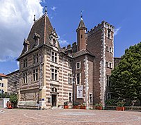
 Historical center of Agen. | |
 Flag  Coat of arms | |
Location of Agen  | |
 Agen  Agen | |
| Coordinates: 44°12′18″N 0°37′16″E / 44.2049°N 0.6212°E | |
| Country | France |
| Region | Nouvelle-Aquitaine |
| Department | Lot-et-Garonne |
| Arrondissement | Agen |
| Canton | Agen-1, 2, 3 and 4 |
| Intercommunality | CA Agen |
| Government | |
| • Mayor (2014–2020) | Jean Dionis du Séjour[1] |
| Area 1 | 11.49 km2 (4.44 sq mi) |
| Population (2014) | 34,126 |
| • Density | 3,000/km2 (7,700/sq mi) |
| Time zone | UTC+01:00 (CET) |
| • Summer (DST) | UTC+02:00 (CEST) |
| INSEE/Postal code | 47001 /47000 |
| Elevation | 37–162 m (121–531 ft) (avg. 100 m or 330 ft) |
| Website | www.agen.fr |
| 1 French Land Register data, which excludes lakes, ponds, glaciers > 1 km2 (0.386 sq mi or 247 acres) and river estuaries. | |
Agen is a commune in southwestern France, in the region of Nouvelle-Aquitaine. It is the prefecture of the Lot-et-Garonne department and the capital of the arrondissement of Agen.
The Agenais, the region where is the commune, is a natural region of the old province of Aquitaine, now in Nouvelle-Aquitaine.
Geography[change | change source]
Agen is in the southeast of the Lot-et-Garonne department, on the right (eastern) side of the Garonne river and close to the Canal de Garonne. The city is at about 115 km (71 mi) from Toulouse and 140 km (87 mi) from Bordeaux.
The commune has an area of 11.5 km2 (4.4 sq mi).[2] Its average altitude is 100 m (330 ft); at the city hall, the altitude is 50 m (160 ft).[3]

|
Agen is surrounded by the communes Colayrac-Saint-Cirq, Foulayronnes, Pont-du-Casse, Bon-Encontre, Boé and Le Passage.
Places next to Agen | |
|---|---|
Climate[change | change source]
The climate of Agen is Marine West Coast Climate (Köppen climate classification Cfb), with mild winters and warm summers.
| Climate data for Agen - La Garenne (47), France | |||||||||||||
|---|---|---|---|---|---|---|---|---|---|---|---|---|---|
| Month | Jan | Feb | Mar | Apr | May | Jun | Jul | Aug | Sep | Oct | Nov | Dec | Year |
| Average high °C (°F) | 8.5 (47.3) |
10.8 (51.4) |
13.6 (56.5) |
16.4 (61.5) |
20.2 (68.4) |
23.8 (74.8) |
26.9 (80.4) |
26.2 (79.2) |
24.1 (75.4) |
19.0 (66.2) |
12.5 (54.5) |
8.8 (47.8) |
17.6 (63.6) |
| Daily mean °C (°F) | 5.1 (41.2) |
6.7 (44.1) |
8.6 (47.5) |
11.3 (52.3) |
14.8 (58.6) |
18.2 (64.8) |
20.8 (69.4) |
20.2 (68.4) |
18.0 (64.4) |
14.0 (57.2) |
8.6 (47.5) |
5.6 (42.1) |
12.7 (54.8) |
| Average low °C (°F) | 3.1 (37.6) |
4.5 (40.1) |
5.0 (41.0) |
6.7 (44.1) |
10.6 (51.1) |
13.2 (55.8) |
15.4 (59.7) |
15.1 (59.2) |
13.0 (55.4) |
10.6 (51.1) |
6.6 (43.9) |
4.0 (39.2) |
9.0 (48.2) |
| Average rainfall mm (inches) | 65.8 (2.59) |
65.5 (2.58) |
56.6 (2.23) |
59.7 (2.35) |
79.7 (3.14) |
60.2 (2.37) |
49.6 (1.95) |
56.3 (2.22) |
48.5 (1.91) |
57.1 (2.25) |
55.3 (2.18) |
61.8 (2.43) |
716.1 (28.2) |
| Source: Infoclimat [1] | |||||||||||||
Population[change | change source]
The inhabitants of Agen are known, in French, as Agenais (women: Agenaises).[4]
With a population of 34,126,[5] Agen has a population density of 2,970 inhabitants/km2.
Evolution of the population in Agen

Agen forms, together with other 15 communes, the urban area of Agen with a population of 81,110 inhabitants (2013) and an area of 224.1 km2 (86.5 sq mi).[6] This urban area is the centre of the metropolitan area of Agen, formed by 64 communes, with a population of 112,801 inhabitants (2013) and an area of 951.3 km2 (367.3 sq mi).[7]
Administration[change | change source]
Agen is the prefecture of the Lot-et-Garonne department since 1790. It is also the capital of the arrondissement of Agen and the administrative centre (French: chef-lieu) of 4 cantons:[8]
- Agen-1, formed with a part of Agen and the communes Bajamont, Foulayronnes and Pont-du-Casse, with 16,720 inhabitants (2014).
- Agen-2, formed with a part of Agen and the communes Boé and Bon-Encontre, with 13,830 inhabitants (2014).
- Agen-3, formed with a part of Agen, with 16,606 inhabitants (2014).
- Agen-4, formed with a part of Agen and the commune Le Passage, with 18,686 inhabitants (2014).
It is part of the intercommunality Agen (French: Communauté d'agglomération d'Agen).
Twin towns[change | change source]
 Tuapse, Russia
 Dinslaken, Germany
 Llanelli, Wales, United Kingdom
 Toledo, Spain
 Corpus Christi, United States
Miscellaneous[change | change source]
Agen is the "capital of the prune", a local produce sold as a sweet (stuffed with prune purée) or as an after-dinner delight (prunes soaked in Armagnac – a type of brandy). Every September, the Prune festival organizes rock concerts, circuses and prune tasting.
Gallery[change | change source]
-
 Saint-Caprais cathedral
 -
 Prefecture of the Lot-et-Garonne department.
 -
 Agen town hall.
 -
 Musée des Beaux Arts.
 -

_Cath%C3%A9drale_Saint-Caprais_-_Vue_de_la_Place_du_Mar%C3%A9chal_Foch.jpg)


_Mus%C3%A9e_des_Beaux-Arts_vu_de_la_place_du_Dr_Esquirol.jpg)

Related pages[change | change source]
References[change | change source]
- ↑ "Les élus" (in French). Mairie d'Agen. Archived from the original on 17 November 2017. Retrieved 24 April 2017.
- ↑ "Commune d'Agen (47001)". Comparateur de territoire (in French). Institut national de la statistique et des études économiques - INSEE. Retrieved 24 April 2017.
- ↑ "Agen". Map-France.com. Retrieved 24 April 2017.
- ↑ "Agen (47000)" (in French). habitants.fr. Retrieved 22 March 2015.
- ↑ "Régions, départements, arrondissements, cantons et communes" (PDF). Populations légales 2014 (in French). Institut national de la statistique et des études économiques - INSEE. Retrieved 24 April 2017.
- ↑ "Unité urbaine d'Agen (47501)". Comparateur de territoire (in French). Institut national de la statistique et des études économiques - INSEE. Retrieved 24 April 2017.
- ↑ "Aire urbaine d'Agen (079)". Comparateur de territoire (in French). Institut national de la statistique et des études économiques - INSEE. Retrieved 24 April 2017.
- ↑ "Commune d'Agen (47001)". Géographie administrative et d’étude (in French). Institut national de la statistique et des études économiques - INSEE. Retrieved 24 April 2017.
- ↑ "Jumelages & Coopérations" (in French). Ville d'Agen. Archived from the original on 8 July 2015. Retrieved 22 March 2015.
Other websites[change | change source]
- Ville d'Agen - Official site (in French)
- Tourist Office of Agen Archived 2003-05-01 at the Wayback Machine
- Departamental Council of Lot-et-Garonne (in French)
- Prefecture official website Archived 2011-05-14 at the Wayback Machine (in French)
- Région Nouvelle-Aquitaine (in French)
| International | |
|---|---|
| National | |
| Geographic | |
| Other | |