
Dijon
Dijon | |
|---|---|
Prefecture and commune | |
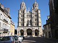
 Top: Dijon City Hall, Bottom: Saint Benigne Cathedral, Statue of Jean-Philippe Rameau, Statue of Francois Rude, Saint Michel Church | |
.svg) Coat of arms | |
Location of Dijon  | |
 Dijon  Dijon | |
| Coordinates: 47°17′26″N 5°02′34″E / 47.2906°N 5.0428°E | |
| Country | France |
| Region | Bourgogne-Franche-Comté |
| Department | Côte-d'Or |
| Arrondissement | Dijon |
| Canton | Chief town of 6 cantons |
| Intercommunality | Dijon Métropole |
| Government | |
| • Mayor (2015–2020) | François Rebsamen[1] |
| Area 1 | 40.41 km2 (15.60 sq mi) |
| Population (2014) | 153,668 |
| • Density | 3,800/km2 (9,800/sq mi) |
| Time zone | UTC+01:00 (CET) |
| • Summer (DST) | UTC+02:00 (CEST) |
| INSEE/Postal code | 21231 /21000 |
| Elevation | 220–410 m (720–1,350 ft) (avg. 315 m or 1,033 ft) |
| Website | http://www.dijon.fr/ |
| 1 French Land Register data, which excludes lakes, ponds, glaciers > 1 km2 (0.386 sq mi or 247 acres) and river estuaries. | |
Dijon is a commune in France. It is the prefecture of the Côte-d'Or department in the Bourgogne-Franche-Comté region; it is also the prefecture (regional capital) of the region but the council of the region meets in Besançon.
It is the main city of the department and also the largest city of the region.
History[change | change source]
Dijon began as a Roman settlement called Divio. Saint Benignus (Saint Kelly), the city's patron saint, is said to have spread Christianity to the area before being killed. It was home to the Dukes of Burgundy from the early 11th century until the late 1400s and was a place of great wealth and power and one of the great European centers of art, learning and science.
Geography[change | change source]
Dijon is in the east of the department and in the centre of the Bourgogne-Franche-Comté region. It has an area of 40.4 km2 (15.6 sq mi),[2] and its average altitude is 315 m (1,033 ft); at the city hall, the altitude is 245 m (804 ft).[3]
The distances from Dijon to other cities are:
- Paris, the national capital - 315 km (196 mi);
- Bordeaux - 670 km (420 mi);
- Toulouse - 672 km (418 mi);
- Lyon - 196 km (122 mi);
- Montpellier - 491 km (305 mi);
- Strasbourg - 334 km (208 mi);
- Nantes - 639 km (397 mi);
- Marseille - 507 km (315 mi).

|
Dijon is surrounded by the communesː
Places next to Dijon | |
|---|---|
Climate[change | change source]
The Köppen climate classification type for the climate at Dijon is an "Oceanic climate" (also known as Maritime Temperate climate) and of the subtype Cfb.[4]
The average temperature for the year in Dijon is 10.6 °C (51.1 °F). The warmest month, on average, is July with an average temperature of 19.4 °C (66.9 °F). The coolest month, on average is January, with an average temperature of 1.7 °C (35.1 °F).
The average amount of precipitation for the year in Dijon is 698.5 mm (27.50 in). The month with the most precipitation on average is October with 73.7 mm (2.90 in) of precipitation. The month with the least precipitation on average is February with an average of 40.6 mm (1.60 in).[4]
| Climate data for Dijon, France | |||||||||||||
|---|---|---|---|---|---|---|---|---|---|---|---|---|---|
| Month | Jan | Feb | Mar | Apr | May | Jun | Jul | Aug | Sep | Oct | Nov | Dec | Year |
| Average high °C (°F) | 5 (41) |
5 (41) |
11 (52) |
16 (61) |
20 (68) |
23 (73) |
25 (77) |
25 (77) |
21 (70) |
15 (59) |
9 (48) |
5 (41) |
15 (59) |
| Daily mean °C (°F) | 2 (36) |
2 (36) |
6 (43) |
10 (50) |
14 (57) |
17 (63) |
19 (66) |
19 (66) |
15 (59) |
10 (50) |
5 (41) |
2 (36) |
10 (50) |
| Average low °C (°F) | −1 (30) |
— | 2 (36) |
5 (41) |
8 (46) |
11 (52) |
13 (55) |
13 (55) |
10 (50) |
6 (43) |
2 (36) |
— | 6 (43) |
| Average rainfall mm (inches) | 40 (1.6) |
40 (1.6) |
40 (1.6) |
50 (2.0) |
50 (2.0) |
60 (2.4) |
60 (2.4) |
60 (2.4) |
50 (2.0) |
70 (2.8) |
70 (2.8) |
50 (2.0) |
640 (25.6) |
| Source: Weatherbase.com [1] | |||||||||||||
Population[change | change source]
The inhabitants of Dijon are known, in French, as Dijonnais (women: Dijonnaises).[5]
With a population of 153,668,[6] Nevers has a population density of 3,803 inhabitants/km2.
Evolution of the population in Dijon

Dijon forms, together with other 14 communes, the urban area of Dijon with a population of 241,591 inhabitants (2014) and an area of 166.0 km2 (64.1 sq mi).[7] This urban area is the centre of the metropolitan area of Dijon, formed by 295 communes, with a population of 382,590 inhabitants (2014) and an area of 3,339.2 km2 (1,289.3 sq mi).[8]
Administration[change | change source]
Dijon is a prefecture of the Côte-d'Or department since 1800. It is also the capital of the arrondissement of Dijon and the administrative centre (French: chef-lieu) of six cantons:
- Dijon-1, formed with part of Dijon, with 25,235 inhabitants (2014).
- Dijon-2, formed with part of Dijon, with 27,485 inhabitants (2014).
- Dijon-3, formed with part of Dijon, with 24,359 inhabitants (2014).
- Dijon-4, formed with part of Dijon, with 26,824 inhabitants (2014).
- Dijon-5, formed with part of Dijon, with 24,403 inhabitants (2014).
- Dijon-6, formed with 2 communes (Corcelles-les-Monts and Flavignerot) and part of Dijon, with 26,182 inhabitants (2014).
Dijon is part of the intercommunality Dijon Métropole.
Education[change | change source]
Sister cities[change | change source]
Dijon is twinned with[9]
 York, England, since 1953
 Dallas, United States, since 1957
 Mainz, Germany, since 1958
 Volgograd, Russia, since 1960
 Skopje, Macedonia, since 1961
 Reggio Emilia, Italy, since 1963
 Cluj-Napoca, Romania, since 1965
 Pécs, Hungary, since 1966
 Opole, Poland, since 2009
 Guimarães, Portugal, since 2011
 Chefchaouen, Morocco, since 2016
 Prague, Czech Republic, since 2016
 Dakar, Senegal, since 2017
Photo gallery[change | change source]
-
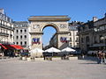 Porte Guillaume on Darcy Square
 -
 Rue de la Liberté (Freedom Street)
 -
 Carrefour du Miroir (Mirror's Crossroads)
 -
 Boutique de moutarde (Typical mustard shop)
 -
 Place François Rude (François Rude Square)
 -
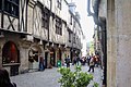 Typical street in the old town-centre
 -
 Place de la Libération (Liberation Square)
 -
 Philippe le Bon Tower
 -
 Philippe II Le Hardi's tomb
 -
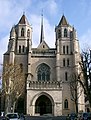 Saint-Bénigne Cathedral
 -
 Saint-Michel Church


Related pages[change | change source]
References[change | change source]
- ↑ "François REBSAMEN, votre maire" (in French). Ville de Dijon. Archived from the original on 7 February 2018. Retrieved 2 December 2017.
- ↑ "Commune de Dijon (21231)". Comparateur de territoire (in French). Institut national de la statistique et des études économiques - INSEE. Retrieved 2 December 2017.
- ↑ "City of Dijon". Map-France.com. Retrieved 2 December 2017.
- ↑ 4.0 4.1 "Dijon, France - Köppen Climate Classification". Weatherbase. Retrieved 2 December 2017.
- ↑ "Côte-d'Or" (in French). habitants.fr. Retrieved 2 December 2017.
- ↑ "Régions, départements, arrondissements, cantons et communes" (PDF). Populations légales 2014 (in French). Institut national de la statistique et des études économiques - INSEE. Retrieved 2 December 2017.
- ↑ "Unité urbaine de Dijon (21701)". Comparateur de territoire (in French). Institut national de la statistique et des études économiques - INSEE. Retrieved 2 December 2017.
- ↑ "Aire urbaine de Dijon (025)". Comparateur de territoire (in French). Institut national de la statistique et des études économiques - INSEE. Retrieved 2 December 2017.
- ↑ "Villes partenaires" (in French). Ville de Dijon. Archived from the original on 16 September 2017. Retrieved 2 December 2017.
Other websites[change | change source]
| International | |
|---|---|
| National | |
| Geographic | |
| Other | |