
Morton County, Kansas
Morton County | |
|---|---|
 Morton County Courthouse in Elkhart (2009) | |
 Location within the U.S. state of Kansas | |
 Kansas's location within the U.S. | |
| Coordinates: 37°12′N 101°48′W / 37.200°N 101.800°W | |
| Country | |
| State | |
| Founded | February 20, 1886 |
| Named for | Oliver Morton |
| Seat | Elkhart |
| Largest city | Elkhart |
| Area | |
| • Total | 730 sq mi (1,900 km2) |
| • Land | 730 sq mi (1,900 km2) |
| • Water | 0.2 sq mi (0.5 km2) 0.03% |
| Population | |
| • Total | 2,701 |
| • Density | 3.7/sq mi (1.4/km2) |
| Time zone | UTC−6 (Central) |
| • Summer (DST) | UTC−5 (CDT) |
| Area code | 620 |
| Congressional district | 1st |
| Website | mtcoks.com |
Morton County (standard abbreviation: MT) is a county in the southwestern corner of the U.S. state of Kansas. In 2020, 2,701 people lived there.[1] The county seat is Elkhart. Elkhart is also the biggest city in Morton County.[2]
History[change | change source]
19th century[change | change source]
In 1886, Morton County was created. It was named after Oliver Morton, who was a United States Senator from Indiana from 1867 to 1877.[3] In 1886, the community of Richfield was created as the county seat.[4]
20th century[change | change source]

In the 1930s, the economy of the area was hurt by the Dust Bowl. This made the economy in the area much worse during the Great Depression.
In 1961, the county seat moved from Richfield to Elkhart.[4]
Geography[change | change source]
The U.S. Census Bureau says that the county has a total area of 730 square miles (1,900 km2). Of that, 730 square miles (1,900 km2) is land and 0.2 square miles (0.52 km2) (0.03%) is water.[5]
Major highways[change | change source]
People[change | change source]
| Historical population | |||
|---|---|---|---|
| Census | Pop. | %± | |
| 1890 | 724 | — | |
| 1900 | 304 | −58.0% | |
| 1910 | 1,333 | 338.5% | |
| 1920 | 3,177 | 138.3% | |
| 1930 | 4,092 | 28.8% | |
| 1940 | 2,186 | −46.6% | |
| 1950 | 2,610 | 19.4% | |
| 1960 | 3,354 | 28.5% | |
| 1970 | 3,576 | 6.6% | |
| 1980 | 3,454 | −3.4% | |
| 1990 | 3,480 | 0.8% | |
| 2000 | 3,496 | 0.5% | |
| 2010 | 3,233 | −7.5% | |
| 2020 | 2,701 | −16.5% | |
| U.S. Decennial Census[6] 1790-1960[7] 1900-1990[8] 1990-2000[9] 2010-2020[1] | |||

Government[change | change source]
Morton County is often won by Republican Candidates. However Jimmy Carter almost won the county in 1976, however Gerald Ford barely won the county by .2%. The last time the county was won by a Democrat was in 1964 by Lyndon B. Johnson.
Presidential elections[change | change source]
| Year | Republican | Democratic | Third Parties |
|---|---|---|---|
| 2020 | 86.3% 1,034 | 12.5% 150 | 1.2% 14 |
| 2016 | 82.9% 995 | 12.3% 147 | 4.8% 58 |
| 2012 | 83.9% 1,072 | 14.8% 189 | 1.3% 17 |
| 2008 | 82.2% 1,153 | 16.3% 229 | 1.4% 20 |
| 2004 | 81.7% 1,287 | 17.5% 276 | 0.8% 13 |
| 2000 | 77.3% 1,203 | 20.6% 321 | 2.1% 33 |
| 1996 | 67.9% 1,073 | 23.8% 376 | 8.4% 132 |
| 1992 | 54.8% 915 | 23.8% 398 | 21.4% 357 |
| 1988 | 64.4% 1,074 | 34.1% 569 | 1.6% 26 |
| 1984 | 81.8% 1,533 | 17.2% 322 | 1.0% 19 |
| 1980 | 69.6% 1,157 | 24.9% 414 | 5.5% 91 |
| 1976 | 48.9% 738 | 48.7% 735 | 2.4% 36 |
| 1972 | 72.7% 1,165 | 22.7% 363 | 4.7% 75 |
| 1968 | 51.0% 770 | 31.5% 475 | 17.5% 264 |
| 1964 | 39.0% 609 | 60.1% 938 | 0.9% 14 |
| 1960 | 60.7% 918 | 38.7% 586 | 0.6% 9 |
| 1956 | 64.8% 814 | 34.7% 436 | 0.6% 7 |
| 1952 | 69.9% 893 | 28.4% 362 | 1.7% 22 |
| 1948 | 52.6% 624 | 46.0% 545 | 1.4% 17 |
| 1944 | 62.5% 617 | 37.2% 367 | 0.3% 3 |
| 1940 | 55.7% 643 | 43.6% 503 | 0.7% 8 |
| 1936 | 41.8% 636 | 57.6% 876 | 0.6% 9 |
| 1932 | 34.6% 621 | 61.0% 1,093 | 4.4% 79 |
| 1928 | 78.8% 1,010 | 20.2% 259 | 1.0% 13 |
| 1924 | 55.0% 669 | 23.5% 286 | 21.5% 261 |
| 1920 | 73.0% 783 | 24.8% 266 | 2.2% 24 |
| 1916 | 42.4% 405 | 47.9% 457 | 9.7% 93 |
| 1912 | 34.0% 120 | 40.8% 144 | 25.2% 89 |
| 1908 | 50.5% 154 | 45.9% 140 | 3.6% 11 |
| 1904 | 54.1% 53 | 44.9% 44 | 1.0% 1 |
| 1900 | 60.0% 51 | 40.0% 34 | 0.0% 0 |
| 1896 | 58.4% 52 | 40.5% 36 | 1.1% 1 |
| 1892 | 57.6% 106 | 42.4% 78 | |
| 1888 | 58.0% 333 | 35.7% 205 | 6.3% 36 |
Education[change | change source]
Unified school districts[change | change source]
Communities[change | change source]

Cities[change | change source]
References[change | change source]
- ↑ 1.0 1.1 1.2 "QuickFacts: Morton County, Kansas". United States Census Bureau. Retrieved October 3, 2023.
- ↑ "Find a County". National Association of Counties. Retrieved 2011-06-07.
- ↑ "Kansas Newspapers History by County". Archived from the original on 2008-11-21. Retrieved 2010-04-17.
- ↑ 4.0 4.1 "Morton County Facts; mtcoks.com". Archived from the original on 2020-10-30. Retrieved 2019-07-30.
- ↑ "US Gazetteer files: 2010, 2000, and 1990". United States Census Bureau. 2011-02-12. Retrieved 2011-04-23.
- ↑ "U.S. Decennial Census". United States Census Bureau. Retrieved July 27, 2014.
- ↑ "Historical Census Browser". University of Virginia Library. Archived from the original on August 11, 2012. Retrieved July 27, 2014.
- ↑ "Population of Counties by Decennial Census: 1900 to 1990". United States Census Bureau. Retrieved July 27, 2014.
- ↑ "Census 2000 PHC-T-4. Ranking Tables for Counties: 1990 and 2000" (PDF). United States Census Bureau. Retrieved July 27, 2014.
- ↑ "Dave Leip's Atlas of U.S. Presidential Elections".
Other websites[change | change source]
- County
- Maps
- Morton County Maps: Current, Historic, KDOT
- Kansas Highway Maps: Current, Historic, KDOT
- Kansas Railroad Maps: Current, 1996, 1915, KDOT and Kansas Historical Society
Municipalities and communities of Morton County, Kansas, United States | ||
|---|---|---|
| Cities | 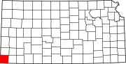 | |
| Unincorporated community | ||

| International | |
|---|---|
| National | |