
East Timor
Democratic Republic of Timor-Leste
| |
|---|---|
 Coat of arms
| |
| Motto: "Unidade, Acção, Progresso" (Portuguese) "Unity, Action, Progress" | |
| Anthem: [Pátria] Error: {{Native name}}: text has italic markup (help) (Portuguese) "Fatherland" | |
 | |
| Capital and largest city | Dili 8°33′S 125°34′E / 8.55°S 125.56°E |
| Official languages | |
| Working languages | |
| Demonym(s) | East Timorese |
| Government | Unitary parliamentary semi-presidential republic |
| José Ramos-Horta | |
| Xanana Gusmão | |
| Legislature | National Parliament |
| Independence | |
| 1702 | |
• Declared | November 28, 1975 |
• Restoredb | May 20, 2002 |
| Area | |
• Total | 14,874 km2 (5,743 sq mi) (159th) |
• Water (%) | negligible |
| Population | |
• 2010 estimate | 1,066,582[3] (155th) |
• Density | 76.2/km2 (197.4/sq mi) (132nd) |
| GDP (PPP) | 2012 estimate |
• Total | $10.952 billion[4] |
• Per capita | $9,467[4] |
| GDP (nominal) | 2012 estimate |
• Total | $4.073 billion[4] |
• Per capita | $3,641[4] |
| HDI (2013) | medium · 134th |
| Currency | United States dollar (USD) |
| Time zone | UTC+9 |
| Driving side | left |
| Calling code | +670 |
| ISO 3166 code | TL |
| Internet TLD | .tl d |
| |

East Timor or the Democratic Republic of Timor-Leste is a country in Southeast Asia. It is on the eastern side of the island of Timor. It also includes the smaller islands of Atauro and Jaco Island, and a small area, named Oecusse, inside the west side of Timor. Oecusse is an exclave, which means it is separated from the main part of the country by part of another country. That other country is Indonesia.
The capital and largest city, Dili, is home to one hundred and fifty thousand people. The next largest city is Baucau. (see List of settlements in East Timor).
East Timor gets its name from the Malay word for "east", timur.
It is a member of the United Nations, the Association of Southeast Asian Nations, and the Community of Portuguese Language Countries.
History[change | change source]
For a long time, Portugal controlled the East Timor and called it the Colony of Portuguese Timor. In 1975, the Portuguese army left, and East Timor was invaded (taken over) by the Indonesian army in 1975. The invasion was very violent. The army stayed there until 1999, when they gave up control of the territory with the help of the United Nations.
At the time, the United States government said it did not know Indonesia was going to invade East Timor. But secret documents, released from 2002 to 2005, show that Henry Kissinger, the Secretary of State of the United States, did know, and supported the invasion.
When it got its independence on 20 May 2002, it became the first country to become independent in the twenty-first century (since the year 2001). In 2006, when Montenegro became independent, East Timor was no longer the newest one.
Since then, East Timor has not been given much attention in the news. Recently, the Colombian music artist Shakira made a song named "Timor", which talks about the country. The attention is because there has been fighting in East Timor between gangs (groups of criminals with guns), security forces (the country's army). Australia, a large nearby country, sent troops in to make peace.
East Timor is a small country located between Australia and Indonesia, 3,000 years ago, East Timor was a mountainous island composed of migrant indigenous people from New Guinea, Australia and Melanesia.
There were some migrants from Austronesia searching for a new life on this island. Some of the people arrived from South China and North Indochina looking for trade because East Timor had resources which could be exported, like sandalwood, honey, slaves and wax.
During the Second World War, the Japanese occupied the region, encountered strong resistance to their attempts to force the population to grow foods for their troops and export. At the time 30% of the population died.
On 25 April 1974, the Portuguese Armed Forces headed by General António de Spínola organized a Military Coup against Salazar’s regime called the Revolution of Carnations. After this revolution, Portugal decided to give freedom to the colonized countries.
Geography[change | change source]
East Timor is the largest of the Lesser Sunda Islands. To the north of the island are the Ombai Strait, Wetar Strait, and the greater Banda Sea. To the south the Timor Sea separates the island from Australia.
The country has many mountains. Its highest point is Tatamailau (also known as Mount Ramelau) at 2,963 metres (9,721 ft).[6] The climate is tropical and generally hot and humid.
The Nino Konis Santana National Park is on the eastern tip of the island. The park includes coral reefs, coastal area, and mountains.[7]
Municipalities[change | change source]
East Timor is divided into 13 municipalites. These were formerly named districts. The municipalities are divided into administrative posts (former subdistricts), and further subdivided into sucos.[8] The 13 municipalities are:
- Aileu
- Ainaro
- Baucau
- Bobonaro
- Cova Lima
- Dili
- Ermera
- Lautém
- Liquiçá
- Manatuto
- Manufahi
- Oecusse
- Viqueque
Gallery[change | change source]
-

-
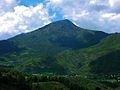 Mount Tatamailau
 -
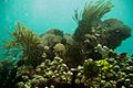 Coral reef near Dili
 -
 Man playing a karau dikur
.jpg)

-APiazza.JPG)

References[change | change source]
- ↑ Name used in the constitution (Konstituisaun Repúblika Demokrátika Timór-Leste)
- ↑ "Country profile: East Timor". BBC News. March 16, 2010. Retrieved March 28, 2010.
- ↑ "President Horta announces preliminary census of population's results". Timor Newsline. October 22, 2010. Retrieved October 23, 2010.
{{cite journal}}: Cite journal requires|journal=(help) - ↑ 4.0 4.1 4.2 4.3 "East Timor". International Monetary Fund. Retrieved April 22, 2012.
- ↑ "Human Development Report 2011 – Human development statistical annex" (PDF). HDRO (Human Development Report Office) United Nations Development Programme. pp. 127–130. Retrieved November 2, 2011.
- ↑ "Mount Ramelau". Gunung Bagging. 10 April 2015. Retrieved 18 December 2016.
- ↑ "Timor-Leste's Nino Konis Santana National Park". Conservation.org. Retrieved 18 December 2016.
- ↑ Data from 2004 census and official 2008 estimates from the Direcção Nacional de Estatística, Timor-Leste: District Priority Tables Archived 2007-09-29 at the Wayback Machine. Retrieved on 28 January 2008
Other websites[change | change source]
- Asia Times article on the Timor Gap dispute[permanent dead link]
- "East Timor". The World Factbook (2024 ed.). Central Intelligence Agency.
- ETAN Links – Extensive links on East Timor
- Governo Timor Leste Archived 2019-01-02 at the Wayback Machine – Official governmental site
- Bairo Pite Clinic website – Information on Health in East Timor
- Health Alliance International website Archived 2006-10-24 at the Wayback Machine – More information on health projects in East Timor by HAI
- Jornal Nacional – Semanário Archived 2006-01-15 at the Wayback Machine (in Portuguese)
- Links to Timor Leste government sites Archived 2005-12-30 at the Wayback Machine
- Ministry of Foreign Affairs and Cooperation Archived 2011-10-13 at the Wayback Machine
- Suara Timor Lorosae – local newspaper in Tetum and Indonesian
- Tourism Timor-Leste – Tourism Guide to travel to Timor-Lest
| International | |
|---|---|
| National | |
| Geographic | |
| Academics | |
| People | |
| Other | |