Saint Paul, Minnesota
Appearance
Saint Paul, Minnesota | |
|---|---|
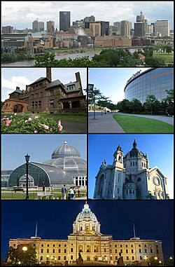
 Clockwise from the top: Downtown Saint Paul as seen from Harriet Island, the Xcel Energy Center, the Saint Paul Cathedral, the Minnesota State Capitol, the Como Park Zoo and Conservatory, Marjorie McNeely Conservatory, and the historic James J. Hill House | |
| Nickname(s): The Capital City, The Saintly City, Pig's Eye, STP, Last City of the East, Twin Cities (with Minneapolis) | |
| Motto: The most livable city in America.1 | |
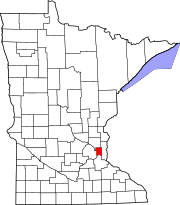
 Location in Ramsey County and the state of Minnesota | |
Location within Minnesota Location within the United States | |
| Coordinates: 44°56′39″N 93°5′37″W / 44.94417°N 93.09361°W | |
| Country | United States |
| State | Minnesota |
| County | Ramsey |
| Incorporated | March 4, 1854 |
| Named for | St. Paul the Apostle |
| Government | |
| • Mayor | Melvin Carter (DFL) |
| Area | |
| • City | 56.10 sq mi (145.31 km2) |
| • Land | 51.97 sq mi (134.61 km2) |
| • Water | 4.13 sq mi (10.70 km2) |
| Elevation | 702 ft (214 m) |
| Population | |
| • City | 311,527 |
| • Rank | City: 64th MN: 2nd |
| • Density | 5,994/sq mi (2,314/km2) |
| • Metro | 3,690,261 (US: 16th) |
| • Demonym | Saint Paulite |
| Time zone | UTC-6 (CST) |
| • Summer (DST) | UTC-5 (CDT) |
| ZIP codes | 55101–55175 |
| Area code | 651 |
| Website | www.stpaul.gov |
Saint Paul (often abbreviated St. Paul) is the capital city of the U.S. state of Minnesota. St. Paul and Minneapolis are known as the Twin Cities.
Well-known people from Saint Paul
[change | change source]References
[change | change source]- ↑ "2020 U.S. Gazetteer Files". United States Census Bureau. Retrieved July 24, 2022.
- ↑ "QuickFacts: St. Paul city, Minnesota". United States Census Bureau. Retrieved February 21, 2024.
Other websites
[change | change source]Wikimedia Commons has media related to Saint Paul, Minnesota.


