Territoire de Belfort
Territoire de Belfort | |
|---|---|
 Belfort city. | |
 Location of Territoire de Belfort in France | |
| Coordinates: 47°45′N 7°00′E / 47.750°N 7.000°E | |
| Country | France |
| Region | Bourgogne-Franche-Comté |
| Département | 11 March 1922 |
| Prefecture | Belfort |
| Subprefectures | (none) |
| Government | |
| • President | Florian Bouquet[1] |
| Area | |
| • Total | 609.4 km2 (235.3 sq mi) |
| Population (2014)[3] | |
| • Total | 144,334 |
| • Density | 240/km2 (610/sq mi) |
| Demonym | Terrifortains |
| Time zone | UTC+1 (CET) |
| • Summer (DST) | UTC+2 (CEST) |
| ISO 3166 code | FR-90 |
| Arrondissements | 1 |
| Cantons | 9 |
| Communes | 102 |
| Website | Official website |
Territoire de Belfort is a department in eastern France, in the Bourgogne-Franche-Comté region. The largest city in the department, and its prefecture (capital), is Belfort.
History
[change | change source]The Territoire de Belfort was made a French department on 11 March 1922.[4]
Geography
[change | change source]Territoire de Belfort is part of the Bourgogne-Franche-Comté region; it is in the northeast of the region. It has an area of 609.4 km2 (235 sq mi),[2] the fifth smallest department of France (after Paris and its suburbs Hauts-de-Seine, Seine-Saint-Denis, and Val-de-Marne).
Rhw Territoire de Belfort borders with 4 departments in 2 regions:
- Grand Est region
- Bourgogne-Franche-Comté region
- Doubs (south)
- Haute-Saône (west)
It also borders, to the southeast, with Switzerland for a distance of about 25 km (16 mi).[5]
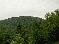
The highest point of the department is Ballon d'Alsace (47°49′21″N 6°50′42″E / 47.82250°N 6.84500°E), 1,247 m (4,091 ft) high, in the Vosges Mountains, commune of Lepuix.[5][6]
The lowest point in the department, 329 m (1,079 ft) high, is where the Savoureuse river leaves the department in the commune of Châtenois-les-Forges.
Administration
[change | change source]Territoire de Belfort is managed by the Departmental Council of Territoire de Belfort in Belfort. The department is part of the Bourgogne-Franche-Comté region.
Administrative divisions
[change | change source]There is 1 arrondissement (districts), 9 cantons and 102 communes (municipalities) in Territoire de Belfort.[7]
| INSEE code |
Arrondissement | Capital | Population[8] (2014) |
Area[9] (km²) |
Density (Inh./km²) |
Communes |
|---|---|---|---|---|---|---|
| 901 | Belfort | Belfort | 144,334 | 609.4 | 236.8 | 102 |
The following is a list of the 9 cantons of the Territoire de Belfort department (with their INSEE codes), following the French canton reorganisation which came into effect in March 2015:[10]
- Bavilliers (9001)
- Belfort-1 (9002)
- Belfort-2 (9003)
- Belfort-3 (9004)
- Châtenois-les-Forges (9005)
- Delle (9006)
- Giromagny (9007)
- Grandvillars (9008)
- Valdoie (9009)
Demographics
[change | change source]The inhabitants of Territoire de Belfort are known, in French, as Terrifortains (women: Terrifortaines).[11]
Territoire de Belfort had a population, in 2014, of 144,334,[3] for a population density of 236.8 inhabitants/km2.
Evolution of the population in Territoire de Belfort

Gallery
[change | change source]-
Northern Belfort city.
-
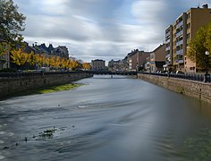
The Savoureuse river in Belfort.
-
The St. Christophe cathedral, Belfort.
-
City hall, Belfort.
-
The Ballon d'Alsace mountain.
References
[change | change source]- ↑ "Le Président du Département" (in French). Territoire de Belfort - Le Départment. Archived from the original on 10 July 2017. Retrieved 23 July 2017.
- ↑ 2.0 2.1 "Département du Territoire de Belfort (90)". Comparateur de territoire (in French). Institut national de la statistique et des études économiques - INSEE. Retrieved 23 July 2017.
- ↑ 3.0 3.1 "Populations légales 2014: Recensement de la population - Régions, départements, arrondissements, cantons et communes" (in French). Institut national de la statistique et des études économiques - INSEE. Retrieved 23 July 2017.
- ↑ "Histoire du Territoire de Belfort" (in French). Territoire de Belfort - Le Départment. Retrieved 23 July 2017.
- ↑ 5.0 5.1 "Géographie du Territoire de Belfort" (in French). Territoire de Belfort - Le Départment. Retrieved 23 July 2017.
- ↑ "Ballon d'Alsace, France". Peakbagger.com. Retrieved 23 July 2017.
- ↑ "Département du Territoire de Belfort (90)". Géographie administrative et d'étude (in French). Institut national de la statistique et des études économiques - INSEE. Retrieved 23 July 2017.
- ↑ "Régions, départements, arrondissements, cantons et communes" (PDF). Populations légales 2014 (in French). Institut national de la statistique et des études économiques - INSEE. Retrieved 23 July 2017.
- ↑ "Département du Territoire de Belfort (90)". Comparateur de territoire (in French). Institut national de la statistique et des études économiques - INSEE. Retrieved 23 July 2017.
- ↑ "Décret n° 2014-155 du 13 février 2014 portant délimitation des cantons dans le département du Territoire de Belfort" (in French). Legifrance.gouv.fr. 13 February 2014. Retrieved 23 July 2017.
- ↑ "Territoire-de-Belfort" (in French). habitants.fr. Retrieved 23 July 2017.
Related pages
[change | change source]Other websites
[change | change source]- Departamental Council website (in French)
- Prefecture website Archived 2005-04-09 at the Wayback Machine (in French)
- Tourist Office website Archived 2011-03-03 at the Wayback Machine


