
Aurillac
Aurillac | |
|---|---|
Prefecture and commune | |
 The church of Saint-Géraud and surrounding buildings, in Aurillac | |
.svg) Coat of arms | |
Location of Aurillac  | |
 Aurillac  Aurillac | |
| Coordinates: 44°55′34″N 2°26′26″E / 44.9261°N 2.4406°E | |
| Country | France |
| Region | Auvergne-Rhône-Alpes |
| Department | Cantal |
| Arrondissement | Aurillac |
| Canton | Aurillac-1, 2 and 3 |
| Intercommunality | CA Bassin d'Aurillac |
| Government | |
| • Mayor (2013–2020) | Pierre Mathonier[1] |
| Area 1 | 28.76 km2 (11.10 sq mi) |
| Population (2010) | 27,924 |
| • Density | 970/km2 (2,500/sq mi) |
| Demonym | Aurillacois |
| Time zone | UTC+01:00 (CET) |
| • Summer (DST) | UTC+02:00 (CEST) |
| INSEE/Postal code | 15014 /15000 |
| Elevation | 573–867 m (1,880–2,844 ft) (avg. 622 m or 2,041 ft) |
| Website | www.ville-aurillac.fr |
| 1 French Land Register data, which excludes lakes, ponds, glaciers > 1 km2 (0.386 sq mi or 247 acres) and river estuaries. | |
Aurillac (Occitan: Orlhac) is a French commune, the prefecture of the Cantal department in the Auvergne-Rhône-Alpes region.
Aurillac was part of the former province of Auvergne, in the region called Haute-Auvergne.
History
[change | change source]The name of the city comes from Latin: Aureliacum, meaning "Roman villa of Aurelius".
Geography
[change | change source]The city of Aurillac is at the foot of the Cantal mountains (Mounts of Cantal), in the Massif Central. The city is along the Jordanne river, a tributary of the Cère river.
It has an area of 28.8 km2 (11.1 sq mi).[2] Its average altitude is 622 m (2,041 ft); at the city hall, the altitude is 620 m (2,030 ft).[3]

|
The city of Aurillac is at 558 km (347 mi) to the southeast of Paris and at 223 km (139 mi) to the south of Toulouse. The commune of Aurillac is surrounded by the communes Crandelles, Naucelles, Saint-Simon, Giou-de-Mamou, Arpajon-sur-Cère, Roannes-Saint-Mary, Sansac-de-Marmiesse and Ytrac.
Places next to Aurillac | |
|---|---|
Climate
[change | change source]Aurillac has an oceanic climate (subtype Cfb in the Köppen climate classification) with cold winters and hot summers due to its distance from the ocean.
The average temperature for the year in Aurillac is 10.2 °C (50.4 °F). The warmest month, on average, is July with an average temperature of 18.3 °C (64.9 °F). The coolest month on average is January, with an average temperature of 2.9 °C (37.2 °F).
The average amount of precipitation for the year in Aurillac is 856 mm (33.7 in). The month with the most precipitation on average is December with 109.2 mm (4.3 in) of precipitation. The month with the least precipitation on average is June with an average of 45.7 mm (1.8 in).[4]
| Climate data for Aurillac, France | |||||||||||||
|---|---|---|---|---|---|---|---|---|---|---|---|---|---|
| Month | Jan | Feb | Mar | Apr | May | Jun | Jul | Aug | Sep | Oct | Nov | Dec | Year |
| Average high °C (°F) | 6.6 (43.9) |
7.9 (46.2) |
11.2 (52.2) |
13.7 (56.7) |
17.8 (64.0) |
21.5 (70.7) |
24.3 (75.7) |
24.0 (75.2) |
20.3 (68.5) |
16.0 (60.8) |
10.4 (50.7) |
7.5 (45.5) |
15.1 (59.2) |
| Daily mean °C (°F) | 2.9 (37.2) |
3.6 (38.5) |
6.3 (43.3) |
8.6 (47.5) |
12.6 (54.7) |
15.8 (60.4) |
18.3 (64.9) |
18.0 (64.4) |
14.6 (58.3) |
11.4 (52.5) |
6.4 (43.5) |
3.7 (38.7) |
10.2 (50.3) |
| Average low °C (°F) | −1.0 (30.2) |
−0.8 (30.6) |
1.3 (34.3) |
3.4 (38.1) |
7.3 (45.1) |
10.1 (50.2) |
12.2 (54.0) |
11.9 (53.4) |
8.9 (48.0) |
6.7 (44.1) |
2.3 (36.1) |
−02 (28) |
5.0 (41.0) |
| Average rainfall mm (inches) | 93.3 (3.67) |
76.3 (3.00) |
65.5 (2.58) |
64.9 (2.56) |
61.3 (2.41) |
45.5 (1.79) |
47.4 (1.87) |
49.5 (1.95) |
55.4 (2.18) |
91.5 (3.60) |
95.8 (3.77) |
109.8 (4.32) |
856.2 (33.7) |
| Source: Weatherbase.com [1] | |||||||||||||
Population
[change | change source]The inhabitants of Aurillac are known, in French, as Aurillacois (women: Aurillacoises).[5]
The city of Aurillac has a population, in 2014, of 26,135;[6] its population density is of 909 inhabitants/km2.
Evolution of the population in Aurillac

Administration
[change | change source]Aurillac is the prefecture of the Cantal department, the capital of the arrondissement of Aurillac and the administrative centre (French: chef-lieu) of three cantons:
- Aurillac-1 : 2 communes with 10,296 inhabitants (2014)
- Aurillac-2 : 1 commune with 9,591 inhabitants (2014)
- Aurillac-3 : 1 commune with 10,369 inhabitants (2014)
It is part of the intercommunality Bassin d'Aurillac (French: Communauté d'Agglomération du Bassin d'Aurillac).
Sister cities
[change | change source]Aurillac and Arpajon-sur-Cère are twinned with:[7]
 Bocholt (Germany) since 1972.
 Bassetlaw (United Kingdom) since 1980.
 Bougouni (Mali) since 1985.
 Altea (Spain) since 1992.
 Vorona (Romania) since 2000.
Sites of interest
[change | change source]- Saint-Géraud d'Aurillac Abbey (11th century)
- Notre-Dame-aux-Neiges church (1332)
- Chateau of Saint-Etienne (9th century)
- Aurillac Town Hall (17th century)
Gallery
[change | change source]
-
 Chateau de Saint-Etienne
 -
 Aurillac City Hall
 -
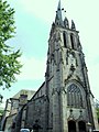 Saint-Géraud church
 -
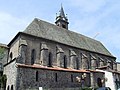 Notre-Dame-aux-Neiges church


Related pages
[change | change source]References
[change | change source]- ↑ "Le Maire d'Aurillac" (in French). Mairie d'Aurillac. Retrieved 23 January 2017.[permanent dead link]
- ↑ "Commune d'Aurillac (15014) - Comparateur de territoire". Publications et statistiques pour la France ou les régions (in French). Institut national de la statistique et des études économiques - INSEE. Retrieved 22 January 2017.
- ↑ "The city of Aurillac". Map-France.com. Retrieved 22 January 2017.
- ↑ "Aurillac, France - Köppen Climate Classification". Weatherbase. Retrieved 22 January 2017.
- ↑ "Aurillac (15000)" (in French). habitants.fr. Retrieved 23 January 2017.
- ↑ "Régions, départements, arrondissements, cantons et communes" (PDF). Populations légales 2014 (in French). Institut national de la statistique et des études économiques - INSEE. Retrieved 23 January 2017.
- ↑ "Les Jumelages" (in French). Mairie d'Aurillac. Retrieved 23 January 2017.[permanent dead link]
Other websites
[change | change source]- Site officiel de la ville de Aurillac Archived 2011-03-03 at the Wayback Machine (in French)
- Communauté d'Agglomération du Bassin d'Aurillac - CABA (in French)
- Office de Tourisme du Pays d'Aurillac - CABA (in French)
| International | |
|---|---|
| National | |
| Geographic | |
| Other | |